PREPARATION OF RIGHT OF WAY DOCUMENTS
Prepared by Right of Way Engineering

Table of Contents
1.0 Introduction .......................................................................................................................................... 1
2.0 Definitions and Abbreviations Used ...................................................................................................... 1
3.0 Right of Way Design Factors to be Considered by All Designers ............................................................ 5
3.1 Proposed ROW Border Width ............................................................................................................. 6
3.2 Proposed ROW Lines .......................................................................................................................... 6
3.3 Treatment of Slopes ........................................................................................................................... 6
3.3.1 Eliminate Small Slope Easements ................................................................................................ 6
3.3.2 Slope Ratio ................................................................................................................................. 7
3.3.3 Slope Easements Not Required for Minimal Slope Height ........................................................... 7
3.3.4 Cost of Retaining Walls or Curb versus Slope Impacts ................................................................. 7
3.4 Driveway Treatment........................................................................................................................... 7
3.4.1 Highway Profile Grade ................................................................................................................ 7
3.4.2 Minimum or Maximum Grade Criteria ........................................................................................ 8
3.5 Signs with Footings............................................................................................................................. 8
3.6 Use of Site Mitigation Easements ....................................................................................................... 8
3.7 Drainage Structures on Private Properties .......................................................................................... 8
3.8 Sight and Clear Zone Easements In Lieu of Fee Takes.......................................................................... 9
3.8.1 Sight Easements ......................................................................................................................... 9
3.8.2 Clear Zone Easements ................................................................................................................ 9
3.9 Utilities .............................................................................................................................................. 9
3.9.1 Consider the Cost of Utility Relocation before Finalizing the Design ............................................ 9
3.9.2 Consider Aerial and Subsurface Utilities before Establishing the ROW Line ................................. 9
3.9.3 Utility Poles May be Placed in Utility Easements ......................................................................... 9
3.9.4 Guy Wire Easements .................................................................................................................. 9
3.9.5 Easement Overlaps ................................................................................................................... 10
3.9.6 Utility Service Lines................................................................................................................... 10
4.0 ROW Process and Submissions ............................................................................................................ 10
4.1 Design Development Meetings ......................................................................................................... 10
4.2 Right of Way Report ......................................................................................................................... 10
4.3 ROW Preparation Process ................................................................................................................ 11
4.4 ROW Submissions Requirements ...................................................................................................... 13
4.5 Comment Resolution Summary ........................................................................................................ 13
4.6 Project Commitments ...................................................................................................................... 14

Right of Way Engineering Manual | 2
5.0 Material Specifications ........................................................................................................................ 14
6.0 Title Search/Deed Abstract ................................................................................................................. 14
7.0 ROW Parcels ........................................................................................................................................ 15
7.1 ROW Fee Parcels .............................................................................................................................. 15
7.2 ROW Easements Parcels ................................................................................................................... 15
7.3 ADA Parcels for ADA Compliant Sidewalks and Curb Ramps ............................................................. 16
7.4 Denial of Access Parcels ................................................................................................................... 18
7.5 Temporary Site Mitigation (Access) Parcels ...................................................................................... 18
8.0 Parcels with NJDEP Involvement ......................................................................................................... 19
8.1 Tideland/Riparian Parcels ................................................................................................................. 19
8.1.1 Tideland Applications for Grants and Licenses .......................................................................... 19
8.2 Green Acres ..................................................................................................................................... 21
8.3 Environmentally Sensitive Parcels .................................................................................................... 22
9.0 ROW Documents Preparation ............................................................................................................. 22
9.1 General Information ......................................................................................................................... 22
9.1.1 Reference Documents Required ............................................................................................... 23
9.2 Entire Tract Map (ETM) .................................................................................................................... 23
9.2.1 Key Sheet ................................................................................................................................. 23
9.2.2 Checklist for Remaining ETMs sheets ........................................................................................ 25
9.2.3 Procedures for ETM Preparation ............................................................................................... 25
9.3 General Property Parcel Map (GPPM) .............................................................................................. 26
9.3.1 General .................................................................................................................................... 26
9.3.2 Checklist (Except For Tab Sheet) ............................................................................................... 27
9.3.3 Procedures ...................................................................................................................................... 27
9.3.4 Alignment Schematic Plan ........................................................................................................ 40
9.3.5 Tab Sheet ................................................................................................................................. 41
9.4 IPM Preparation ............................................................................................................................... 42
9.4.1 General .................................................................................................................................... 42
9.4.2 Checklist ................................................................................................................................... 43
9.4.3 Procedures ............................................................................................................................... 43
9.5 Descriptions ..................................................................................................................................... 45
10.0 Process for Eliminating a Parcel........................................................................................................... 66
11.0 Process for Revising or Subdividing a Parcel........................................................................................ 66
11.1 Revising a Parcel .............................................................................................................................. 66

Right of Way Engineering Manual | 3
11.2 Subdividing a Parcel ......................................................................................................................... 68
12.0 Process for a Condemnation Case ....................................................................................................... 69
13.0 ROW Parcel Dedication Requirements ................................................................................................ 70
14.0 Donated Parcels .................................................................................................................................. 71
Attachment A: Sample of Servient Estate & Dominant Estate Parcels ............................................................ 72
Attachment B: Sample of Servient Estate & Dominant Estate Parcels ............................................................ 73
Attachment C: Sample of G.P.P.M. Title Block ................................................................................................ 74
Attachment D: Standard R.O.W. Legend ......................................................................................................... 75
Attachment E: Standard Legend ..................................................................................................................... 76
Attachment F: Sample of Policy for Retaining Walls ....................................................................................... 77
Attachment G: Sample of Policy for Retaining Walls – Alternate .................................................................... 78
Attachment H: Sample of Slope E. & Ditch Easement Lines ............................................................................ 79
Attachment I: Sample of “Temporary Site Mitigation Work (Access)” ............................................................ 80
Attachment J: Folding Procedure for IPM Prints ............................................................................................. 81
Attachment K: Folding Procedure for IPM Prints: General Notes.................................................................... 82
Attachment L: Sample of Title Area (All Maps) ............................................................................................... 83
Attachment M: Sample of I.P.M. Title Block ................................................................................................... 84
Attachment N: Submissions Requirements Table ........................................................................................... 85
Attachment O: Consultant Quality Control Checklist ...................................................................................... 87
Attachment P: Title Summary Document ....................................................................................................... 88
Attachment Q: Sample of Easement Overlap Area ......................................................................................... 89
Attachment R : Description Samples ............................................................................................................... 90
Attachment S: ROW Engineer Process .......................................................................................................... 104

Page | 1
1.0 Introduction
Right of Way Engineering is the application of sound engineering judgement to
transportation improvements for the purpose of improving and promoting commercial
and residential development within the community while considering future smart growth
with the goal of creating an integrated transportation network.
This manual provides designers with Right of Way Engineering guidance for use in
preparing Right of Way (ROW) plans and documents for NJDOT projects, Local Aid
projects, Developer projects and other public transportation projects. This guidance,
when used in conjunction with the ROW Acquisitions Manual, the Access Design
Guidelines, and the New Jersey State Highway Access Management Code, will help to
establish uniformity in design. This manual will not address every situation the designer
may encounter, but, when used in conjunction with sound engineering judgement and
knowledge, this manual should enable the designer to prepare accurate ROW
documents.
2.0 Definitions and Abbreviations Used
Agricultural Development Area (with 8-year deed restrictions): Property that
cannot be used for other than agriculture for 8 years. The property owner enters into an
agreement with the County Agriculture Board resulting in a restrictive covenant being
attached to the property.
Agreement: Contract between the owner of the subject property and the Department of
Transportation for conveyance of fee or lesser interest of lands set forth in the
description; conveys equitable title as compared to legal title.
Alignment Schematic Plan: A plan used to illustrate the geometry (i.e., alignment,
curve data, etc.) of historic and proposed baselines from which existing and/or proposed
ROW lines are “set”. Plans are designated General Property Parcel Map (GPPM) and
typically precede the Tab Sheet.
Block: A designated (numbered) portion of an incorporated municipality as shown on
the official municipal tax map; comprised of one or more lots each with a unique
designation (numbered).
Bureau of Landscape Architecture and Environmental Solutions (BLAES): The
Office of Landscape Architecture prepares the landscape, architecture, reforestation, and
wetland mitigation plans for projects. The Office of Environmental Solutions (i.e., E-
Teams) is responsible for, amongst other tasks, permits/wetland delineations and
applications, Green Acres coordination, contaminated soil/hazardous waste identification
and wetland mitigation plans. Prepares appropriate documentation (CED, EA, EIS, for
example) to obtain formal environmental approvals from FHWA and/or or NJDEP.
Capital Project Delivery Process: Department process setting forth the tasks and
timing involved in developing a project from project statement through final construction
and post construction activities.
Condemnation: The act of filing of a complaint seeking entry of a final judgment
confirming the proper exercise of the Power of Eminent Domain and the recording of a
Declaration of Taking in the Book of Deeds with the County recording officer.
Course: A boundary of a property that can be described by distance, bearing and/or arc
length.

Right of Way Engineering Manual | 2
Declaration of Taking (DT): The means by which title to a property is acquired after a
condemnation complaint is filed and payment is deposited with the court.
Deed: Conveyance of legal title; a document signed by the owner of the property
conveying real property or an easement to another.
Description: The legal description of the property conveyed identifying the location,
including, but not limited to county, municipality, street, street number block and lot,
metes and bounds of the conveyance, as well as easement rights, if any.
Dominant Estate Parcel (DE): A parcel containing an existing private (usually access,
parking or other similar type) easement owned by another entity encumbering a fee
parcel being acquired. The corresponding fee take will be an SP parcel.
Easement: A right to use land of another for a specific or particular purpose consistent
with the grant under which it was made. Easements can be for utility rights, access
rights, construction rights or non-physical use such as conservation.
Eminent Domain: The power of government to acquire real property, including
improvements, subject to the provisions of the Eminent Domain Law of 1971.
Encumbrance: A lien upon real property.
Entire Tract Map (ETM): A plan used to show the location of all parcels to be acquired
and the remaining area of the property. This map shall be signed and sealed by a New
Jersey licensed surveyor and filed by NJDOT in the courthouse of the county where the
parcels are located.
Et Al: And others, and another.
Et Seq: And following.
Et Ux: And wife.
Et Vir: And husband.
General Property Parcel Map (GPPM): A plan used to show the property to be
acquired. This map shall be signed and sealed by a New Jersey licensed surveyor and
filed by NJDOT or lead agency (such as County, Municipality) in the county courthouse
where the deed was obtained. GPPMs include the Alignment Schematic Plan and Tab
Sheet.
Grant: An instrument that conveys some estate or interest in the lands that it embraces.
Grantee: The person or entity to whom a grant is made; the one who acquires the
property.
Grantor: The person or entity by whom a grant is made; the one who transfers the
property or property rights.
Individual Parcel Map (IPM): A plan that depicts a parcel and related parcels, having
unity of ownership, use and associated easements. It is used for appraising and
negotiating acquisition; it is also used as the map attached as an exhibit to a
condemnation complaint and declaration of taking where and when condemnation is
pursued. It must be based upon and consistent with the GPPM.

Right of Way Engineering Manual | 3
Key Sheet: The first ETM sheet. It identifies the designation and limits of the ROW
Section of a highway and notes the adjoining ROW Section designation(s). It also
identifies the area (or MP limits) where ROW is to be acquired for the ROW of a specific
section of a highway.
Lot: Typically, a designated (numbered) fractional part or subdivision of a block, under
one specific ownership.
Lot Owner Access Concurrence (LOAC): A concurrence form sent to the lot owner by
OAD for acceptance of access alterations.
Lot Owner Lease Agreement (LOLA): A form sent to the lot owner with the LOAC by
OAD offering a nominal amount or administratively determined amount of compensation
for use of the property to construct the access alterations. This form is not used if the
access alterations are within the ROW or OAD determines the alterations to be complex.
Mean High Water Line (MHWL): The line formed by the intersection of the tidal plane
of mean high tide with the shore.
Metes and Bounds: A description of real property which begins at a specified starting
point (point of beginning or P.O.B.) and proceeds, clockwise or counterclockwise, around
the parcel or easement utilizing directions, distances (metes) and monuments (bounds)
as descriptive elements of the property lines and property corners. An area is also
generally given in the deed. This type of land description is usually based on an actual
land survey.
Mitigation: Actions taken to reduce impacts from acquisitions, project environmental
impacts or access changes. Included are:
• Temporary Site Mitigation Work permits NJDOT to enter property to offset
damages to the property caused by acquisition and/or access changes,
adjustments, modifications, or revocations.
• Acquisition of fee parcels or permanent easements from another owner to satisfy
environmental and regulatory permit obligations or reduce damages on an owner’s
property.
• Use of existing NJDOT lands previously acquired by fee or easement to satisfy
environmental and regulatory permit obligations or reduce damages on an owner’s
property. Use of NJDOT lands must be reviewed for parcel clearance through the
Division of Right of Way & Access Management, Technical Support Bureau.
• The proposed action within a specialist “NRE” report which provides owner with a
plan to lessen or correct acquisition damages and an estimate of the
compensation needed for the mitigation.
Monuments: A physical marker, typically set by a surveyor, indicating boundaries, base
lines, or ROW lines.
Navigable Waters: Flowing water courses that are upstream of the tidal zone but are
still navigable. The lands under these water bodies (streams, creeks, brooks) are owned
by the State but are not under the jurisdiction of the Tidelands Resource Council. The
bottom of water bodies that are not tidal or navigable are owned privately, however, the
water itself is under state jurisdiction whether water is tidal, navigable, or otherwise.
New Jersey Department of Environmental Protection (NJDEP): The Department of
the State of New Jersey responsible to protect environmental quality and public health.

Right of Way Engineering Manual | 4
New Jersey Department of Transportation (NJDOT): The Department of the State
of New Jersey responsible for the State highway system.
New Jersey State Highway Access Management Code (Access Code):
Administrative rule that provides a system of access management to protect and
enhance the safety and efficiency of the State highway system and the public investment
in that system, pursuant to New Jersey Statutes Annotated (N.J.S.A.) 27:7-89 et seq.
The Access Code is found in the New Jersey Administrative Code under TITLE 16:
Transportation CHAPTER 47: State Highway Access Management Code.
North American Datum of 1983 (NAD 83): The official plane coordinate system for
the NJDOT.
Office of Access Design (OAD): Office with the responsibility for all access issues
relating to State Highway, Local Aid and projects advanced by others. They review and
set the driveway design within the limits of the project.
Parcel: Real Property (Fee Take) or easement to be acquired for highway or mitigation
purposes. Fee takes are described by metes and bounds.
Parcel Clearance: Lands owned by NJDOT which are to be sold off or used for
mitigation purposes including access mitigation must be cleared to determine if they are
available for use and that no other overriding public use exists. Projects which propose
the use of NJDOT land should begin the Parcel Clearance process through the Technical
Support Bureau early to avoid delays due to unavailability of the proposed excess parcel.
Land acquired as part of a project for a specific mitigation does not normally require a
Parcel Clearance.
Project Manager (PM): Representative of the NJDOT Division of Project Management
who oversees the project from the Final Design phase through construction.
Remaining Area (RA): Property retained by the owner after a portion (Fee Take) of the
property is acquired. If there is not a fee parcel, the remaining area is equal to the
original land area. The RA includes the areas of any associated proposed or existing
easements.
Right of Entry (ROE): A right to enter the property of another for a temporary purpose
given by the owner of the property to the NJDOT. This is to be obtained by a
representative of the NJDOT Division of ROW. This can also include the right to enter
prior to commencement of condemnation or tender of a deed for a permanent easement
or parcel. It is always to be in writing, signed by the owner of the property or authorized
corporate officer where a corporation is involved. Where the entry will be of a longer
duration, or of a more complicated nature, an agreement may be needed. A ROE cannot
be used as a substitute for bona fide negotiations.
Right of Way Impact Plan: Initial set of GPPMs produced during the Preliminary
Engineering Phase and submitted to the Right of Way Technical Support Bureau to
develop the initial ROW estimate.
Right of Way Technical Support Bureau: Unit responsible for activities before and
after negotiations including ROW funding, condemnation coordination, ROW consultant
contracts, approving and selling excess land, plan distribution and technical guidance on
ROW related issues.
Riparian Buffer: Regulated lands adjoining a water body subject to regulatory control
by NJDEP. Impacts to the buffer zone can require mitigation.

Right of Way Engineering Manual | 5
Riparian (Tidelands) Grant: The grant by the State Tidelands Resource Council of its
right to areas within the flow of the mean high tide or areas of land which were
historically flowed by the mean high tide. NJDOT would apply for a Riparian Grant to
build a bridge within tidelands.
Riparian Rights: The rights of the owner of land on the bank of a watercourse relating
to the water, its use and ownership of soil under the watercourse. In this manual, the
term is used only to describe those rights of landowners abutting tidal waters.
Right: A real estate interest in a property (e.g., access, drainage, slope, etc.)
Right of Way (ROW): Land owned by, under the jurisdiction of or to be acquired by
NJDOT or lead agency (such as County, Municipality) for highway purposes or other
public related purposes.
Right of Way (ROW) Border: The area between the curb line or edge of pavement
commonly used for sidewalks, utilities, and other highway features.
Right of Way Engineering (ROWE): The unit that is responsible for the review of the
in-house or consultant designer’s ROW documents.
Servient Estate Parcel (SP): A parcel to be acquired that is encumbered by an existing
private easement (access, parking, or other similar type) owned by another entity.
Slope Rights: An easement over the lands of others abutting the ROW line, upon which
cut and fill slopes may be constructed and maintained to protect or support the roadway.
Tab Sheet: The last GPPM sheet. It contains a tabulation or listing of owners with ROW
impacts.
Tidal Waters: Any watercourse affected by tides. Land beneath the watercourse defined
by the MHWL is subject to the jurisdiction of the Tidelands Resource Council.
Tidelands: Also referred to as riparian lands, are all those lands now or formerly flowed
by the tide in a natural waterway, including filled lands.
Tidelands Claim Line: The line that depicts areas now or formerly flowed at or below
means high tide. These lands are claimed by the State of New Jersey.
Tidelands License: A short term rental agreement from the State of New Jersey for the
use of its currently flowed tidelands. NJDOT applies for licenses for drainage and utility
easements and all temporary easements or rights.
Title: Ownership. Shown on ETMs, GPPMs and IPMs adjacent to the parcel bubble.
Underground Storage Tanks (UST): Subsurface containers which (1) store motor fuel
for noncommercial purposes (more than 1100 Gal.), (2) store heating oil (more than 200
Gal.) or (3) store any quantity of fuel/oil for commercial purposes. Sites that have such
containers are subject to the NJDEP regulations.
3.0 Right of Way Design Factors to be Considered by All
Designers
The following instructions emphasize ways for the designer to be flexible with their
design. This would include both horizontal and vertical geometry. The NJDOT Roadway
Design Manual shall be utilized as a guide as well. For example, when using slope ratios
found in the Manual, the Designer can deviate from the examples, especially when the
height of the slope is minimal. This is further described below. Often there are unique

Right of Way Engineering Manual | 6
situations which are not covered in either manual. In such cases, good engineering
judgment and consultation with a ROW Subject Matter Expert (SME) shall prevail over
the written word. Therefore, the intent is to limit the overall number of takings and when
ROW impacts are unavoidable, to minimize them such a degree that the scope of
damages to the remaining property (remainder) is minimized to the greatest extent
practical. The goal is thus twofold:
• To reduce the number of takings to what is reasonably practical and does not
interfere with the effectiveness or safety of the overall intended project.
• To limit damages that may be suffered by the remainder of a property due to a
partial acquisition. If it is determined that a partial acquisition is necessary, the
designer should consider the need for flexibility and any feasible option to reduce
the impact of the acquisition. If the impact cannot be reduced or is more extensive
than anticipated, it may be more economical for the Department to acquire the
entire property and to promote relocation of the owner rather than to attempt to
mitigate prospective damages.
3.1 Proposed ROW Border Width
Before beginning the ROW design, the Designer should consider vehicle safety and
usage, pedestrian safety and usage, the environment, and the community in the
corridor. At that point the scope and/or width of the ROW border should be determined.
When designing the ROW border width, even though 10 or 15 foot border is desirable,
there are no stipulations for a minimum ROW width (border) for State, County, or local
roads. Proposed or relocated sidewalks, guiderail, utilities poles, underground utilities,
highway signs and other highway features should be considered when designing the
ROW border width. For example, a sidewalk width may vary based on the existing
conditions and does not need to be parallel to the curb. Also, consider design speed and
the required clear zone. Therefore, if the highway has no facilities and no clear zone
issues and the acquisition needs to be minimized, the ROW line could be set on or just
behind the curb line.
3.2 Proposed ROW Lines
Although desirable, the proposed ROW line does not have to be parallel to the curb line
or the edge of roadway. If it does not adversely affect the safety of the motoring public
the design of the line can have various angle points and offsets to avoid or minimize
impact to parking lots, private signs and lighting, buildings, sensitive environmental
areas, private drainage structures, fences, or other features.
The ROW line can also be set to exclude the acquisition of a particular property because
of its historic importance or because it renders a necessary social, educational,
governmental, or environmental service to the community or because its acquisition
would have severe impact on the economics of a particular project, the viability of the
property or result in disproportionate acquisition costs. The Designer on each project
should consult with the Project Manager before considering these factors in their design.
3.3 Treatment of Slopes
3.3.1 Eliminate Small Slope Easements
Slope easements of two feet wide or less should be avoided. Usually, the slope can be
moved in toward the existing or proposed ROW without significantly reducing the
preferred 2:1 (H: V) ratio. If moving the slope is not possible, locating the proposed

Right of Way Engineering Manual | 7
ROW line to capture the slope is the next best option. In other words, for example, a
ten-foot-wide border is generally better than an eight-foot-wide border with a two-foot-
wide slope. Under this scenario one right is acquired instead of two, which simplifies the
acquisition process. However, if a wider taking significantly increases damages to the
remainder, such as reducing the building set back to less than the minimum required,
the slope easement should remain. Note that the “wash and spread” area is part of the
slope easement. Also, see Attachment H.
3.3.2 Slope Ratio
The slope ratio may be reduced from 2:1 to 1.5:1 to 1:1 to minimize ROW impacts.
Consider maintenance issues on steeper slopes. For example, rip rap may be needed on
a steeper slope instead of grass. Consult with Landscape and/or Geotechnical
Engineering for any slope design changes and or treatment. In addition, steep slopes
may create significant damages to the remainder and should be avoided near residential
development, schools, or where children or elderly may pass; where a steep slope is
utilized, appropriate protection from falls by nearby pedestrians must be considered.
Also, minimize the use of 4:1 to 6:1 slope. If slopes do not support the highway, a
temporary grading easement could be used instead.
3.3.3 Slope Easements Not Required for Minimal Slope Height
Slopes under approximately six inches high generally do not support the highway. It is
not practical to design or construct a slope at that height or lower. Also, a steeper ratio
at that height will not adversely affect the support of the highway. If a sidewalk or
parking lot is involved, header curb may be used to avoided constructing slopes with
minimal heights.
3.3.4 Cost of Retaining Walls or Curb versus Slope Impacts
Consideration shall be made in using retaining walls, landscape walls, or vertical curb
instead of slopes when designing highway borders. This is because slope easements may
be quite expensive especially in north and central New Jersey commercial markets as
well as along the coast. Often it is perceived that a wall will be too expensive to
construct and/or maintain. The acquisition costs or the damages awarded to an owner
(amount paid the owner and the administrative costs) may significantly exceed the
additional construction costs of erecting a wall in comparison to construction and
maintenance of a slope. A cost benefit analysis needs to be performed in consultation
with the Department to determine whether the substitution of a slope with a wall is in
fact the least expensive alternative.
3.4 Driveway Treatment
3.4.1 Highway Profile Grade
When the proposed vertical profile results in changes to the elevation along the edge of
the highway, the grading and side slopes of the adjoining driveways will need to be
adjusted. The grading and associated work on these driveways, if required to extend
outside the ROW may be covered by a Temporary Site Mitigation Work Area (Access)
(TSMWA) (Note: See Sections 7.5 and 9.3.3.H.3.b for further instruction on the use of
this easement).

Right of Way Engineering Manual | 8
3.4.2 Minimum or Maximum Grade Criteria
When designing a driveway profile, consider whether the vehicle will “bottom out” on any
part of the driveway. The maximum grades can be found in the NJ State Highway Access
Management Code, Section 16:47 - Appendix E. The maximum grades may be adjusted
slightly if the safety of the driveway is not compromised. Compound profiles may be
used. Also, if the elevation difference of the proposed roadway and driveway is six inches
or less, the maximum and minimum grades should not apply. The six inch or less
difference can be run out in a shorter distance without affecting the vehicle traveling
across the driveway. Proposed grading should be within ROW or a proposed easement.
3.5 Signs with Footings
Relocation of private signs that are supported on footings should be avoided unless
absolutely necessary. These types of signs include, but are not limited to, single or
multiple pylon aerial signs, ground level signs, or billboard signs. The location of
proposed ROW lines and slope easement lines can be flexible if highway safety is not
compromised. So, consideration should be given to angling the proposed ROW line
(typically at 90 degrees) to keep footings and sign panels outside of the ROW and
designing the roadside slope and easement line to avoid impacting footings. ROW
Engineering and Technical Support shall be consulted for input when determining if a
private sign needs to be moved. If any sign or other structure must be moved, the State
could pay the owner to move their sign. If the State’s contractor moves the sign, a
Temporary Site Mitigation Work Area will be required.
3.6 Use of Site Mitigation Easements
A “Temporary Site Mitigation Work Area” or “Temporary Site Mitigation (Access)” is an
easement provided for the State’s contractor when mitigating damages to a private
property from the proposed highway construction. The easement should not be set off
the baseline, instead a width and/or length of the easement could be used to depict the
work area. The easement shall be a closed area with easement lines will generally
intersecting with existing or proposed ROW or property lines. No part of the State
highway is to be constructed from this easement. See Attachment I for an example.
Also, to minimize damages or interference to ongoing use of the private property, a
staging plan should be devised to be followed by the contractor, especially for large
commercial properties in areas of needed parking and along store fronts where vehicular
and pedestrian access to ongoing businesses could be affected.
3.7 Drainage Structures on Private Properties
At times the drainage flow on private properties may be adversely affected due to the
proposed work. The mitigation of potential damages may include construction of inlets or
other drainage structures on these properties. If the drainage is not part of the State
system, a temporary site mitigation easement shall be used instead of a drainage
easement. Where the capacity of the State drainage system permits drainage of the
private property, a clause will be added to the description regarding the acceptance of
private runoff water into the State system, as shown in Section 9.5.C.18 of the ROWE
Manual. This clause could include provisions for changes to existing drainage basins. The
property owners will be responsible for maintenance of these structures unless the
structure failure will affect the structural integrity of nearby infrastructure. In that case,
other easements can be considered.

Right of Way Engineering Manual | 9
3.8 Sight and Clear Zone Easements In Lieu of Fee Takes
3.8.1 Sight Easements
Sight easements or sight triangle easements (if in that shape) should be used in place of
fee acquisitions when the reason for the taking is for line of sight only. This prevents the
owner from constructing or planting anything that would restrict a driver’s line of sight.
They could be used on intersection corners and the inside of horizontal curves.
3.8.2 Clear Zone Easements
If there is a clear zone requirement, such as the area behind a guide rail end terminal, a
clear zone easement should also be considered instead of a fee take. However, a utility
or aerial utility easement may be used in combination with a sight triangle or clear zone
easement. When determining what type of easement to use, it is important to consider
all design factors including, but not limited to ITS, traffic signal structures, proposed
signs, highway lighting, and all utilities. For additional guidance on ROW, clear area, and
roadside recovery area around guide rail refer to the Roadway Design Manual,
Figures 8-D, 8-I2, 8-P1 & 8-R.
3.9 Utilities
3.9.1 Consider the Cost of Utility Relocation before Finalizing the Design
Since the cost of utility relocations is relatively high when compared to ROW costs and
often construction costs every effort should be made to minimize the acquisition of utility
easements. If that is not possible, a different design may have to be considered.
3.9.2 Consider Aerial and Subsurface Utilities before Establishing the ROW
Line
Several utilities may share one proposed easement (combinations of would-be water,
gas, cable, electric, etc.). It may cost less to acquire more ROW than to move all or
certain utilities. Also, if proposed utility relocations conflict with a private sign, it is
usually less expensive to move the sign. Prior to setting easements to accommodate
utility construction, including temporary construction easements for temporary
relocations, permanent utility easements, permanent aerial utility easements, and any
shared-use utility easements, the designer shall seek concurrence with the utility
company.
3.9.3 Utility Poles May be Placed in Utility Easements
It is desirable to keep utility poles within the ROW. However, a utility easement may be
used when a fee parcel is deemed too costly or not feasible for other reasons. For
example, when a utility pole might be placed on private property outside of a required
fee area, an easement may be considered.
3.9.4 Guy Wire Easements
Guy wire easements should be considered when the need and location for proposed guy
wires is definitive (i.e., highway crossing) and a direct result of impacts from the project.
However, the acquisition of guy wire easements is not recommended in cases where
their proposed locations are subject to change in construction. Use a UE parcel to acquire
the rights to construct the guy wire.

Right of Way Engineering Manual | 10
3.9.5 Easement Overlaps
Two or more temporary or permanent easements can overlap (occupy the same space) if
two or more separate rights are being acquired. For example, a utility easement and a
slope easement usually would overlap. The area of the overlap should be labeled and
described on GPPMs and IPMs as shown in Attachment Q. However, if the work is similar
or both easements required the work area to be graded, the similar work can be
incorporated into the main easement. For example, a drainage easement and grading
easement would not overlap.
3.9.6 Utility Service Lines
A temporary construction easement can generally be used for relocations of utility
service lines to private properties. Under ground and above ground facilities including
service poles can be included within the limits of the easement.
4.0 ROW Process and Submissions
4.1 Design Development Meetings
During a project’s Concept Development (CD) phase the NJDOT Project Manager with the
Designer hold meetings (i.e., Scope Team/Core Group Meetings) with the internal
stakeholders and SMEs. These meetings introduce the project to the SMEs, obtain
information from the various SME groups and start to address concerns from all
disciplines. Once the affected disciplines are identified, a Core Group is formed, and
members hear concerns from other disciplines and may recognize that solving one
problem may adversely affect another. At this time ROW impacts are identified and
assessed. The goal of the Core Group is to consider all input including the ROW impacts
and reach a consensus on the project scope and the Preliminary Preferred Alternative
(PPA).
Dissemination of information and communication between all stakeholders and team
members is an essential and an integral part of the successful project delivery process.
Educated Team Members make informed decisions and earn credibility with external
stakeholders and the general public.
If a County, Municipality or entity is the lead agency for a project, that agency will
develop their own alternatives and may consult NJDOT’s SMEs for input through the
Local Aid and Economic Development Division.
4.2 Right of Way Report
The ROW Designer is responsible for preparing a ROW Report during the Preliminary
Engineering (PE) phase of the project. The report, which is to be submitted by the
designer prior to the initial ROW kickoff meeting, is intended to demonstrate that
alternatives were considered to avoid or lessen the impact of all ROW acquisitions. The
underlying premise is that the designer shall first attempt to utilize only the existing
ROW. Only after concluding that the intended scope and goals of the Transportation
Infrastructure Improvement Project cannot be accommodated within the existing ROW
should the acquisition of parcels or easements be considered. The following should be
written in a ROW Report:
Preparation of a “Right of Way Report” should include the following:

Right of Way Engineering Manual | 11
• Project Description – This description lists the existing conditions, reasons for
the proposed work, stakeholders, funding limitations, historical or environmental
restraints or any other issue that must be considered when designing the ROW.
• Project Narrative - These states the reasons for the ROW design and the effect
on the project and/or safety of highway users if ROW was not acquired or the
acquisitions were limited.
• ROW Impact Summary – This is a list which includes the numbers, areas, and
types of ROW takings such as fee parcels, permanent and temporary easements,
and tidelands parcels. This list should be on an Excel formatted spreadsheet titled
“Parcel Information Form” which can be found on the DOT website. This
spreadsheet will be an aid in preparing the initial ROW estimate. Information can
be updated, added, deleted, or changed for each subsequent ROW submission.
See Section 9.3.5.C for further information.
• Description of Each Parcel – A statement, usually one paragraph describing the
type and need for the parcel, the duration for temporary easement rights, impacts
to the remainder and any information unique to the parcel. If there are several
similar parcels on a large project, the descriptions may be combined.
• Conclusion – This section could state the time needed for construction of the
project, the need for any Access Impact Assessment reports, property relocations
or any other information that effects the entire project.
• Appendices – If applicable, NJDEP Green Acres Information, Tideland/Riparian
maps and documents, an overall plan of the entire project and tax maps are
examples of appendices that could be added. The Parcel Information Form can
also be an appendix.
Three copies of the report shall be submitted at the initial ROW Kickoff meeting. ROWE
will provide examples of ROW Reports.
4.3 ROW Preparation Process
To prepare the ROW documents and at the same time minimize acquisition delays, the
following process is established for ROW document submissions. All days are calendar
days. See Attachment N for submission requirements. All submission shall be sent to the
Division of ROW, Technical Support Bureau, and ATTN: Project Coordination & Funding.
1. A ROW Kickoff Meeting shall be held after the ROW Report has been completed and
after the Designer substantially progresses the ROW Impact Plan. The Project
Manager will schedule the meeting and invite the attendees listed below. The
designer will present the ROW Report. The ROW and access design for the project will
then be customized. At this meeting the ROW Report (see Section 3), will be
presented and will describe all proposed ROW impacts. The Project Manager will
schedule the meeting and invite the listed attendees below.
The ROW Engineering Unit will run the meeting.
Attendees shall include:
• ROW Engineering (ROWE) Unit
• Technical Support Unit
• Office of Access Design (OAD)
• ROW District Office Representative
• Design Consultant Representative(s)

Right of Way Engineering Manual | 12
• Title Unit or Title Company Representative
• Surveyor
• Division of Project Management Project Manager
• NJDOT Environmental staff
The Project Manager will ensure that the following presentation material is
available at the time of the meeting:
• Most recent construction plans with proposed geometry, preliminary drainage,
and preliminary utility impacts.
• Aerial plan covering the proposed work area.
• The current ROW Impact Plan in hard copy and PDF.
The ROWE Unit will supply the Designer with sample documents (if requested), map
quotes and potential parcel numbers. The Designer will record the minutes of the
meeting and distribute them to all attendees.
Note: On Local Aid and Economic Development Division projects, the Local Aid project
manager will organize and send invitation to attendees. Their attendees shall include
County, Municipality or lead agency designers, ROW personnel and other
representatives.
2. A ROW Impact Plan Submission shall be submitted in accordance with the
schedule established by the NJDOT Project Manager (PM). It shall contain two sets of
prints of the GPPMs (without the Alignment Schematic Plan and Tab Sheet, except
include the chart for temporary easement durations); each sheet shall be stamped
with “ROW IMPACT PLAN”. These submission requirements are also listed in
Attachment N. This submission is to be used by the Division of ROW to develop the
initial ROW cost estimate.
3. A ROW Plans and Documents Submission shall be submitted after completion of
the Title Search as described in Attachment N and the Capital Project Delivery
Process and in accordance with the schedule established by the Division of Project
Management Project Manager (PM). ROWE will perform a quality review of the
documents to assure conformance to current standards. Comments will be returned
to the Designer approximately 3 to 4 weeks after the submission has been received.
The Designer will then prepare a ROW Plans and Documents Submission Comment
Resolution Summary (CRS-See 4.5) to address comments from ROWE, the District, or
other SMEs.
4. A Pre-Final ROW Submission shall be submitted approximately two to four weeks
before the Final Submission date as established by the PM. The submission
requirements are listed in Attachment N. This review will ensure that all ROW Plans
and Documents Submission comments have been addressed, allow ROWE to review
any new or changed parcels/descriptions and the accuracy of all ROW documents
before the extensive printing required for the Final Submission. However, before the
Final ROW submission, the Designer will then complete the Pre-Final CRS and submit
the CRS for review by ROWE.
5. A ROW Acquisition Kickoff Meeting will be held at the ROW District office shortly
after the Pre-Final ROW submission. The meeting shall be requested by the PM and
the ROW District will be the lead for inviting the appropriate SMEs and the meeting
will usually be held at the ROW District office. This meeting will allow the ROW
acquisition team to become familiarized with each parcel.

Right of Way Engineering Manual | 13
Attendees could include:
• Technical Support Unit
• Design Consultant
• DAG
• Potential Appraiser
Presentation materials shall be transmitted to the District prior to the meeting and
should include the following:
• PDFs of the Individual Parcel Maps (IPM)
• The latest Construction Plans
• The latest Access Cutouts
• Aerial Plan of the project area in PDF
• Comment Resolution Summary from the ROW Plans and Document Submission
Communications between Project Manager, Designer and Division of ROW and Access
Management need to be ongoing and not limited to the above-mentioned meetings.
6. A Final ROW Submission shall be submitted after approval of the Pre-Final CRS and
as described in Attachment N and in accordance with the schedule established by the
PM. The letter of transmittal shall state the number of parcels to be acquired for the
contract and list all parcels that were changed since the ROW Plans and Documents
Submission. OAD will also provide the Technical Support Bureau with the status of all
access cases, the access cutouts, final or access conclusion letters and a list, in the
form of a spreadsheet, of signed Lot Owner Access Concurrence forms and Lot Owner
Lease Agreement forms or required SA parcels. See the Access Design Guidelines and
Sections 7.5 and 9.3.3.H.3.b for further guidance.
Notes:
1. Any change in these schedules must be requested through the Division of Project
Management PM during Final Design.
2. The ROW process is summarized on a flow diagram in Attachment S.
4.4 ROW Submissions Requirements
The ROW Submission requirements for all phases of the ROW process can be found in
Sections 3 and 4 and Attachment N. Attachment N lists the numbers of copies of each
document required for all units. A submission package will be considered incomplete if
any of the items mentioned in Attachment N are missing. If there is an incomplete Final
ROW Submission, the start time assigned to the ROW Division to complete ROW
acquisitions for the project will be delayed until the missing items are submitted. Also,
for all submissions the Designer shall submit Attachment O, “Consultant Quality Control
Checklist”.
4.5 Comment Resolution Summary
To ensure that all comments are addressed, and revisions incorporated on the Pre-Final
and Final ROW Submissions the Designer shall prepare a ROW Comment Resolution
Summary (CRS) after the ROW Plans and Documents and the Pre-Final ROW
Submissions. The CRS shall be submitted to ROWE in memorandum form with each
comment and the reviewer’s unit listed. All comments will be addressed with each review
unit giving a concurrence or an objection to responses to each of their comments. When
there is an objection to a response, the Designer will resolve the issue with the
commenting unit and ROWE. ROW Engineering and OAD will then approve the CRS

Right of Way Engineering Manual | 14
before the next ROW submission and ROWE will distribute the approved CRS to the units
that provided the comments.
4.6 Project Commitments
All project commitment letters or memorandums that involve local municipalities,
Landscape, ROW, Access, Construction and Environmental or other agencies or groups
will be attached to the ROW Plans and Documents Submission package letter. If project
commitments change after this submission, new commitment letters or memorandums
will be attached to subsequent submission packages.
Proposed non highway mitigation items such as creation of park areas, docks or parking
lots for environmental mitigation need to have commitments for ownership and
jurisdiction in place to proceed with the design. This includes obtaining binding
agreements from the proposed recipients prior to final commitments by the Department
regarding the purchase and/or construction of mitigation items.
5.0 Material Specifications
ETM and GPPM plans shall be prepared on print paper on 22” x 36” sheets.
The Parcel Information Form shall be submitted on 8 ½” x 14” or 11” x 17” paper and
electronically.
IPMs shall be submitted on print paper and are limited to a maximum (as measured from
the cutting edge) of 30" x 42". Parcels may be submitted on 8 ½” x 13", 11” x 17”,
15” x 17”, 15” x 21”, 18” x 24”, 22” x 36” and 24” x 36” size paper. For large parcels
where match lines are necessary, plan sheets are limited to 22” x 36”. The designer
should use the smallest legible map size that shows the parcel and conforms to the
requirements of Section 9.4.
Parcel descriptions shall be prepared on 8 ½” x 11” paper and are also submitted
electronically, on CDs or other formats approved by ROW Engineering and ROW
Technical Support.
Riparian/Tidelands Grant and application documents, except for the plans, shall be
prepared on 8 ½” x 11” paper.
When final ETMs and GPPMs are requested for County filing, unless otherwise instructed,
plan sheets shall be of synthetic film, such as Mylar, and shall be 4 mils thick and matted
on both sides. Signed and sealed mylars to be submitted must use ink that does not
come off with handling. Erasures and changes shall be made in accordance with
instructions given for the material used so as not to harm the permanent original tracing.
6.0 Title Search/Deed Abstract
Historical data shows that the quality of ROW plans is compromised when title searches
are limited to the last deeds recorded. The last deeds may not always reflect all
easements and encumbrances on the impacted properties; therefore, their exclusive use
could delay the ROW acquisition process.
A full Title Search/Deed Abstract shall be completed prior to preparing the ROW Plans
and Documents in accordance with the Capital Project Delivery Process. The ROW
Closing Bureau Manager will determine if the Title Search/Deed Abstract will be
conducted by the In-House Title Unit, outsourced to an Independent Title Company, or
should be included in the project budget and hired by the Designer.

Right of Way Engineering Manual | 15
If the work will be outsourced, the Designer or the Title Closing unit will be responsible
for hiring a Title Company. The Scope of Work for the Title Company will then be
provided by the In-House Title-Unit to the Project Manager. Close coordination with the
In-House Title Unit shall be maintained throughout this process.
A Title Summary Document, as shown on Attachment P, will be provided to the NJDOT
Project Manager at the completion of the Title Search/Deed Abstract.
7.0 ROW Parcels
7.1 ROW Fee Parcels
Property and underlying rights to be acquired by the State of New Jersey for highway,
mitigation or other public purposes is accomplished by “fee” parcels. Fee parcel numbers
(and easement parcel numbers) are provided to the designer by ROWE. Fee parcel
number do not have a prefix unless noted below. These parcels are depicted on ETMs,
GPPMs, IPMs, and in descriptions. Guidance for the preparation of “fee” parcels is
contained in each of those sections. The types of “fee” parcels are as follows:
Entire acquisition - Whole property is acquired with No Remaining area (RA).
Partial acquisition – An unencumbered portion of the property is acquired, and the
owner has RA.
Riparian - Use “T” with the parcel number.
Utility - Use “U” with the parcel number.
Servient Estate - Use "SP" with the same parcel number as that of the unencumbered
fee. (See Attachments A and B).
Dominant Estate –Use "DE" with a parcel number designated for the owner of the
easement (a different number than that of the servient estate parcel number). (See
Attachments A and B). See Section 9.3.3.H.15.
Remainder Acquisitions – Remaining areas of properties that are acquired but not
needed for highway purposes.
Mitigation Parcels – Parcels beyond the Proposed ROW Line that are needed for
mitigation purposes and are not needed for the project. Fee mitigation parcels should be
identified as “M”.
Note: Fee parcels may be acquired subject to utility rights.
• See Section 9.3.3.G for more information.
7.2 ROW Easements Parcels
The acquisition of property rights less than a fee interest, for a particular use by the
State for highway, mitigation, or other public purposes, is accomplished through
easement parcels. The current property owner still has possession of the land within the
easement subject to rights of the easement holder (the State or other private or public
party). These parcels are depicted on ETMs, GPPMs, IPMs, and in descriptions. They are
designated with the “E” followed by the parcel numbers unless otherwise noted below.
Guidance for the preparation of “easement” parcels in each of Section 9.3.3.H.

Right of Way Engineering Manual | 16
The more common types of easement parcels are as follows:
• Slope
• Grading
• Drainage
• Utility – Designated by a UE (any utility) or AE (aerial only).
• Bridge
• Construction and Maintenance
• Temporary Construction
• Private Designated by “PE”.
• Perpetual Access Easement - Designated by “PAE”.
• Temporary Diversionary Road
• Sight Easement or Site Triangle
• Temporary Site Mitigation Work Area – Designated by “S”. See Sections 7.5
and 9.3.3.H.3.a.
• Temporary Site Mitigation Work Area (Access) – also known as “SA” parcels.
See Sections 7.5 and 9.3.3.H.3.b.
• Mitigation Easement – Designated by an “ME”.
An “E” or “S” parcel designation are not used if the easement is contiguous to a fee
parcel or the main easement parcel. In those cases, the easement or work area is listed
under the main parcel bubble and as a rider in the description. Parcels with the prefix
“AE”, “ME”, “PAE”, “PE”, “SA” and “UE” are designated separately regardless of if there is
another acquisition involved.
7.3 ADA Parcels for ADA Compliant Sidewalks and Curb Ramps
Projects, often Limited Scope pavement resurfacing projects, may result in ROW impacts
associated with the construction of sidewalks and curb ramps to comply with the
Americans with Disabilities Act (ADA). Generally, such ROW impacts are minor, which
allows the ROW Acquisition Team to utilize a shorted process, known as Administered
Determination of Value (ADV), to acquire these parcels and compensate the property
owners. Fee takings, permanent sidewalk easements or temporary sidewalk work areas
may be required, and the criterion for their use is noted below (also refer to 9.5.C.31).
The requirements for ROW plans depicting these parcels are the same as for other
parcels.
1. For Fee Parcels:
a. Criteria for use:
I. Where a new sidewalk is constructed (including curb ramps) partially or
completely outside the ROW, spans the length of at least one lot and the
location of the proposed ROW line does NOT cause a violation of the
municipal setback or other zoning requirements.
II. Where the new sidewalk would be in the clear zone.
III. Where there are other proposed ground structures such as guide rail or traffic
signal equipment in the area of the sidewalk.
IV. At corners of side streets where ROW was the not acquired to construct
sidewalks connecting the Highway with the side street.
V. As directed by ROWE.

Right of Way Engineering Manual | 17
b. On the ROW plans show ‘sets’ (stationing and offsets) for the fee parcels to the
nearest hundredth of a foot.
2. For Permanent Sidewalk Easements:
a. Criteria for use:
I. Where a new sidewalk is constructed outside the existing ROW and does not
span the entire length of at least one lot and/or where the new will cause a
violation of the municipal setback or other zoning requirements.
II. Where existing sidewalk is to be reconstructed outside its existing footprint
and is completely or partially outside the ROW.
III. Where a fee take is not required and where ADA ramps are outside of the
ROW even if reconstructed within their existing footprint.
b. Propose only sidewalk or related work shall be within the easement.
c. On the ROW plans, label the easement area “Permanent Sidewalk Easement
Area”.
d. On the ROW plans, label the proposed easement line “Permanent Sidewalk
Easement Line”.
e. Show ‘sets’ (stationing and offsets) to the nearest tenth of a foot.
3. For Temporary Sidewalk Work Areas:
a. Criteria for use:
I. Where the proposed or reconstructed sidewalk is within the right of way and
workspace needed is beyond the ROW.
II. Where sidewalk is reconstructed within its existing footprint even if footprint
is outside of the ROW. (curb ramps excluded)
III. Curb Ramp is completely within the right of way, but workspace needed is
beyond ROW.
b. Label as “Temporary Sidewalk Work Area” on the ROW plans.
c. Propose only sidewalk or related work shall be within the easement.
d. Show the ‘sets’ (stationing and offsets) to the nearest foot.
4. Combined ADA Ramp and Sidewalk Construction:
If all or any part of a curb ramp is constructed outside the right of way and
temporary sidewalk work is required and is contiguous to the ADA ramp, then all the
work may be combined into a “Permanent Sidewalk Easement Area”. Both temporary
sidewalk work areas and permanent sidewalk easements may be used if the
temporary sidewalk work extends 10 feet beyond the ADA ramp construction.
5. General Notes:
1. Fee takes and permanent sidewalks easement shall always be shown on the
General Parcel Property Maps (GPPMs) and Individual Parcel Maps (IPMS).
2. GPPMs are not required if the only acquisitions on a project ROW section are
temporary sidewalk work areas.

Right of Way Engineering Manual | 18
3. Generally, on project ROW sections where there are both permanent sidewalk
easements and temporary work areas show both on the GPPMs and IPMS. Consult
ROW Engineering about if unsure what to depict.
4. In the legal descriptions for easements or work areas, describe the exact work
being performed.
5. There may be situations where construction of ADA ramps and sidewalk do not
exactly match the criteria for use or general notes listed above.
7.4 Denial of Access Parcels
Denial of Access parcels are shown as a proposed line with cross hatching (see Standard
Legend) and are used for limiting direct access across ROW lines. They designated with
“DA” (permanent) or “TDA” (temporary). They do not have a parcel area, but the
remaining is noted under on the ROW plans. This is a property right that is acquired
through eminent domain and is separate from the “removal of driveway” under the New
Jersey State Highway Access Management Act. See Sections 9.3.3.H.20 and 9.5.C.1 for
more information.
7.5 Temporary Site Mitigation (Access) Parcels
Also known as “SA” parcels. “SA” Parcel designation is given only to that work
specifically related to work or mitigation for the alteration of access including paving and
work to allow driveways to conform to the NJ State Highway Access Management Code.
It is distinct from any other mitigation or easement and is used to allow the appraiser to
differentiate between access required mitigation and any other mitigation caused by an
acquisition.
• OAD will send a Lot Owner Access Concurrence (LOAC) and Lot Owner Lease
Agreement (LOLA) to property owners on State Highway projects where access
related work extends outside the ROW line. Place the following note on the GPPM
and IPM when the owner signs both forms: “The Owner has signed a LOLA for
construction of the driveway(s) and associated site improvements identified on
this plan.” This note should be used even if other ROW is being acquired on the
affected property. Also, before putting the note on the GPPM and IPM, ensure that
the driveway construction depicted on the ROW plans matches the driveway
construction on the access cutout. If the LOLA is not executed, the designer must
prepare ROW documents for a “Temporary Site Mitigation Work Area (Access)”
easement. The easement will be an individual parcel designated by “SA” followed
by the appropriated number.
• If an SA parcel is required, label areas where the State’s contractor is performing
access related work as “Temporary Site Mitigation Work Area (Access).” This work
may or may not be due to implementation of the New Jersey State Highway
Access Management Code (Access Code). Access related work includes moving or
closing driveways, paving, and grading driveways and striping the parking lot or
reconstructing islands on the parking lot to mitigate circulation problems.
• Show a short, dashed line showing the limits of the work if the driveway related
work is outside the ROW Line. A 5-foot distance between the physical limits of
work and the dashed line is generally used. However, a shorter or longer distance
may be used dependent on field conditions and ROW impacts. Label the line
“Temporary Site Mitigation Work Line (Access).” Stations and offsets are not
required on the line.

Right of Way Engineering Manual | 19
• Use a separate “SA” parcel designation.
• Use the appropriate clause in the description.
• Do not consider slopes along graded driveways as part of the roadway toe or top
of slope (this is the limit Temporary Site Mitigation Work Area (Access)). Carry
roadway slopes across each driveway as though the driveway did not exist. See
Attachment I. This slope line across the driveway represents the toe or top of
slope for support of the highway. Use the appropriate slope clause.
NOTES:
1. LOACs and LOLAs are sent out if the access related work is or is not a result of
implementation of the Access Code.
2. On State highway projects, LOACs and LOLAs are generally sent to owners with
driveways within the limits of the construction project, even if they are on a
county or local road.
3. If the work is entirely within the ROW, only a LOAC may be sent to the owner and
no parcel or signature note will be required.
4. A LOLA form is not used if the access alterations are within the ROW or if OAD
determines the alteration are complex.
5. In all cases, even when where the owner signs LOAC and LOLA, SA Parcels are not
to be shown on the plans or in the description. However, the lines shall remain on
the plans, labeled as a “Temporary Site Mitigation Work Line (Access)” and the
aforementioned note added indicating that the LOLA was signed.
8.0 Parcels with NJDEP Involvement
Since the acquisition of any right from the NJDEP (including their units such as Green
Acres, Tidelands, etc.) is a time consuming and labor-intensive activity, it is critical that
all aspects of possible acquisitions are carefully considered. The need to properly identify
all existing riparian/tidelands grants and licenses or properties with NJDEP outright
ownership is paramount. It is the responsibility of the Designer to clearly identify any
issues as early as possible. Otherwise, the project schedule may be adversely affected.
The Designer is to coordinate with ROW, the Project Manager, and possibly the Division
of Law whenever NJDEP issues arise.
8.1 Tideland/Riparian Parcels
NJDOT acquires Tideland or Riparian parcels where areas over or in tidal waters are
needed for highway improvement projects. Tideland parcels in fee are labeled “T”
followed by the assigned number and Tideland parcels acquired as easements ate
labeled “TE” followed by the number.
8.1.1 Tideland Applications for Grants and Licenses
The Designer must complete a Tidelands application where acquisition of a
Riparian/Tidelands parcel. If land is filled below the MHWL or another permanent right,
except for drainage or utilities, is required a Grant application shall generally be
prepared. If only a temporary right or drainage or utility easement is needed, a License
application shall generally be prepared. Always confirm with the NJDEP Bureau of
Tidelands Management (Tidelands Bureau) which type of application is required. Since
the time frame to acquire a License is significantly less than to acquire a grant it is

Right of Way Engineering Manual | 20
imperative to distinguish between the two early in the design process. The application
includes Tidelands Maps, Tidelands parcel description and forms.
The procedure for preparing Tideland applications and documents is as follows:
1. Identify any parcels located along or adjacent to tidally flowed water bodies where
existing or proposed right of way may have riparian issues. The Tidelands Resource
Council (TRC) has jurisdiction for lands below the current tidal Mean High-Water Line
(MHWL) and also claims lands which were formerly flowed by the tide, but which are
now filled in due to manmade causes. The NJDEP Bureau of Tidelands Management
(Tidelands Bureau) serves as the staff for the TRC and reviews applications and
makes recommendations to the TRC. The NJ-GeoWeb at the NJDEP website can assist
in determining if a project falls within an area of potential tidelands. This application
provides user’s access to NJDEP GIS Data on the internet. Currently the website has
a quick start guide.
2. Contact the Tidelands Bureau to verify any riparian involvement for acquisitions or
existing right of way, either below the MHWL or on uplands which the Tidelands
Bureau has identified as “Formerly Flowed” claimed areas on their maps. Any recent
filled areas not shown on the maps are the result of later human influence are subject
to a claim by the TRC. The Designer should consult with ROWE where a claimed area
can be proven to exist entirely due to natural tidal action.
3. Meeting with Tidelands: If there is riparian land involvement, schedule a meeting
with the Tidelands Bureau to gather and confirm data required on the ROW
documents. The Designer shall define the existing mean high-water line and provide a
current NAVD88 elevation for the MHWL for parcels bordering on or inclusive of a tidal
watercourse. This line must be accurately established in the field and confirmed with
NJDEP. The designer shall utilize the NJDEP Tidelands claims maps to define any
lands formerly flowed by the mean high tide located in or near right of way
acquisition areas. The Tidelands claims maps are filed in each county and municipality
where tidelands are located. Copies may be purchased from the Bureau of Tidelands
Management, NJ Dept. of Environmental Protection in Trenton, NJ. Tidelands
information is also available from the NJDEP website.
4. Lands below MHWL: Label tidelands parcels on lands below the MHWL that will
become filled land (the area approaching a bridge for example) with the “T”
designation. Tidelands parcels over the MHWL (easement areas needed to construct a
bridge and footings or any other permanent or temporary tidelands easement) shall
be labeled with the “TE” designation. Show and label the same as other fee areas or
easements.
5. Lands above the MHWL with claimed areas: The TRC treats filled lands as if they
belong to the upland owner, subject to a Tidelands claim. Parcels subject to “Formerly
Flowed Claims Lines” are treated as part of the upland owner’s land. The designer
shall list only the upland owner of any property with “Formerly Flowed Claims Lines”
in the Title Bubble (not NJDEP) and shall not use “T” or “TE” (riparian) designations
for formerly flowed lands above the MHWL. However, the area of the “Formerly
Flowed Claims” encumbrance within each acquisition area shall be calculated and
shown both at the claimed area and listed under the parcel bubble. This area is to be
labeled “Formerly Flowed Claim Area = ___”. The RA shall be the deed or calculated
property area minus the fee parcel area. The parcel area is the sum of both the

Right of Way Engineering Manual | 21
encumbered and unencumbered areas. The plan shall show the total parcel area and
the area of the encumbrance (formerly flowed claims line).
6. Tidelands Maps: The maps are titled “Existing and Proposed Tidelands” unless
otherwise specified by the Tidelands Bureau. IPM are not used. In preparing maps for
Tidelands Bureau use, the Designer should simplify the line work as much as possible
so that the Mean High-Water Line(s), Claim Lines, edges of roads, footings and
property lines are clear and readily identifiable. The Tidelands Bureau prefers the use
of colors on their maps and the Designer may vary from the normal color scheme for
these maps. Maps for submission to the Tidelands Bureau must indicate the owners‟
names for all adjoining properties, with the respective lots and blocks. The maps also
need to identify any easements or right of ways on adjoining lands which are needed
to permit the placement of utilities or drainage through tidelands. The TRC will not
grant any utility or drainage rights unless they are assured there is a legal right to
use the adjoining upland areas. These tideland rights are granted as licenses. Grants
will require survey data from the Designer in the New Jersey Plan Coordinate System
and maps for Tidelands are required to be sealed and signed (typically 4 to 6 copies).
Survey requirements can be found on the DEP website at NJDEP-Division of Land
Resource Protection.
7. Descriptions: The description for a Tidelands (“T” or “TE”) parcel should be written
like other descriptions except “T” parcel areas require an actual mete and bounds
with a point of beginning (POB) based on NJ Plane Coordinates. In special
circumstances the Tidelands Bureau may require metes and bounds for other Grant
areas (permanent easements/TE parcels). All descriptions should include as many
rights as possible. The right to enter, maintain, flow water, construct, install utilities,
etc. should be included in the descriptions for Riparian Parcels. See Sections 9.5.C.32
and 9.5.C.33, and Attachment R for description clauses and examples.
8. The Tideland application and additional background information is in the NJDOT
Tidelands Application Guidelines which can be found at NJDOT Engineering
(state.nj.us). Tideland Application forms and instruction can also be found on the
NJDEP website at NJDEP-Division of Land Resource Protection.
9. Submission: When completed, the designer shall then submit the prints, description
and application as shown in Attachment N for each submission. The ROW Technical
Support Bureau will forward the application and required documents to the Bureau of
Tidelands Management, NJ Dept. of Environmental Protection (Tidelands Bureau).
8.2 Green Acres
The Green Acres Program acquires land for the Department of Environmental Protection
(DEP) that becomes part of the system of state parks, forests, natural areas, and wildlife
management areas. Green Acres does not own the land it acquires; instead, land is
assigned to the DEP's divisions of Parks and Forestry, Fish and Wildlife, and the New
Jersey Natural Lands divisions listed above for management. For example, the Wharton
State Forest is owned by the State of NJ and is managed by DEP’s Division of Parks and
Forestry.
The Green Acres program provides low interest (2%) loans and grants to municipal and
county governments to acquire open space and develop outdoor recreation facilities. This
land is also considered Green Acres encumbered.

Right of Way Engineering Manual | 22
The Designer should anticipate that any acquisition of publicly owned parkland or open
space will have Green Acres impacts. This is true even in urban areas. Any acquisition
from a local government or agency, regardless of use, should be checked to ensure that
there is not Green Acres involvement.
Acquisitions from Green Acres encumbered land must show coordinates at the POB of
the parcel. The parcels must mathematically close, therefore a property survey must be
performed on the lot with Green Acres encumbrance. See more information on Green
Acres surveys at NJDEP Green Acres - Standard Scope of Survey Services.
8.3 Environmentally Sensitive Parcels
1. Define environmentally sensitive parcels as early as possible in the design process.
These parcels will be identified by BLAES during the preparation of the documents for
the Categorical Exclusion (CE), Environmental Assessment (EA), Environmental
Impact Statement (EIS) or EO 215 (State Funded Projects). The Division shall notify
the ROW designer of all environmentally sensitive parcels as soon as they are
identified.
2. Acquisition from any of the following example properties (but not limited to) will
qualify them as environmentally sensitive parcels:
• Section 4(f) properties
• Green Acre properties
• Historic Properties (Section 106 Involvement)
• Landfills
• Tidelands
• Formally Flowed Tidelands
• Areas subject to wetlands or riparian controls
• Agricultural or conservation restriction easements
3. Identify environmentally sensitive parcels on the Parcel Information form. See
Sections 4.2 and 9.3.5.C.
4. Wetlands and their buffers, tidelands, conservation and agricultural restriction
easements and forested areas should be drawn on the GPPMs and IPMs.
9.0 ROW Documents Preparation
9.1 General Information
The preparation of all ROW maps shall comply with New Jersey Statutes Annotated
(N.J.S.A.) 46:26B 1-8 and New Jersey Administrative Code (N.J.A.C.) 13:40-5.1
(minimum survey detail requirements as promulgated by the State Board of Professional
Engineers and Land Surveyors). The ROW Title unit or other designated unit within the
NJDOT will file each sheet of the ETMs & GPPMs with the appropriate County recording
officer when all parcels contained within an individual ETM or the individual GPPM have
been acquired. Also, place a combined Map Filing Statement on the Key Sheet in the
lower left corner of the Key Sheet (see Checklist in Section 9.2.1.A).
In placing labels and notes on any map or plan sheet, it is important to arrange the
labels and notes so that the topography remains clear and legible.
Topography features must remain visible to ensure that impacts to the property are
identified and can be fully understood by appraisers, property owners, officers of the
court and others.

Right of Way Engineering Manual | 23
All ETMS and GPPMs shall have a Revision Block. See Section 11 for information on
revisions.
9.1.1 Reference Documents Required
Documents in the preparation of ROW maps that shall be required, if applicable to a
particular project and where available, include, but are not limited to:
• Latest deeds, wills, all easements, leases, and other property rights documents on
each property involved.
• Historic ROW plans (and/or construction plans) on-file with NJDOT (plans
requested through EDU), other agencies, and/or counties.
• Current tax maps, development maps, zoning maps, county maps or master
plans.
• Road returns, where applicable.
• Filed maps establishing public ROW.
• Vacations for streets that have been abandoned.
• Proposed or accepted dedications.
• Prior land surveys on properties with proposed ROW impacts.
• Subdivision Plans and Site Plans (Preliminary and/or final), if applicable.
• Municipal Resolutions and status of “paper” streets.
These documents, and in-particular any monuments (see Section 9.3.3.B) that are
recoverable, will aid the Designer in developing a mosaic of existing ROW lines and best-
fit property/easement lines suitable for the preparation of ROW plans in compliance with
this Manual and the NJ Map Filing Law. It is paramount that the Designer be able justify
how the existing ROW lines were re-established abutting areas of ROW impacts.
9.2 Entire Tract Map (ETM)
9.2.1 Key Sheet
A. Checklist
Item
Yes
No
Scale
Title Block/Surveyor’s Title Block
Construction project reference
Map showing location of the project
Corporate lines
North Arrow
The term KEY MAP
Limits of ROW section
Adjacent ROW section(s)
Designer’s name
Project location
Map Filing Statement

Right of Way Engineering Manual | 24
B. Procedures
1. The Key Sheet shall be the first sheet, covering the entire ROW section. It should
indicate the project area, showing partial coverage of adjoining sections, including
mileposts and stations at the beginning and end of the ROW project.
2. The Key Sheet shall be prepared at a convenient scale to show the entire ROW section
plus partial coverage of the adjacent ROW section(s). The New Jersey licensed Land
Surveyor’s Title Block is required on all ETMs, shall comply with N.J.A.C. 13:40-1.1,
1.2, and 1.3, et seq. (including signature and original seal on final Mylar) and shall be
placed above the NJDOT Title Block or in the lower left corner as an alternate location.
ROWE will supply a sample of the licensed Land Surveyor’s Title Block at the Initial
Meeting.
3. Center the map on the sheet. It shall show corporate lines, names of counties,
municipalities, major highways, streets, any geographical and manmade features
(lakes, rivers, railroads, etc.)
4. Center the term KEY MAP below the map showing the project location with a bar scale
also centered below.
5. Show the limits of the ROW section outside of the KEY MAP by lines extending into the
map to the locations on the subject route that are the beginning and end of that section.
6. Show a portion of the adjacent ROW sections in the same manner as in 8) above. The
portion shown should be enough to readily identify the adjacent ROW sections and can
be determined at the Initial Meeting when the designer is unsure of the limits.
7. Show the ROW project location by highlighting the subject route on the KEY MAP and
designating the limits of the ROW project in a similar method to the NJDOT Sample
Plans for construction projects, which are available on the NJDOT website.
8. Show the Map Filing Statement in the lower left corner of the sheet. It should show a
blank line for number of sheets and break out the number of ETMs and GPPMs. For
example, ___ SHEETS FILED IN THE OFFICE OF THE MERCER COUNTY CLERK, ___
ETMS AND ___ GPPMS. Leave one line of space below the above statement and add
DATE. Add FILE NO on the next line below. The number sheets will be written in the
blanks prior to filing with the County. This statement is not required on any other
sheet.

Right of Way Engineering Manual | 25
9.2.2 Checklist for Remaining ETMs sheets
Item
Yes
No
Scale
Title Block/Surveyor’s Title Block
North Arrow
Revision Block
Designer’s name
Baselines (Existing & Proposed)
Block and lot for each property
Existing deed course information not shown on the GPPMs
Proposed parcel lines
Parcel numbers
Entire Property shown
Adjacent owners
Building and structures
Municipal and county lines
GPPM layout
9.2.3 Procedures for ETM Preparation
A. Scale: 1” = 100’ throughout (other scales may be used if approved by the
ROWE Unit). Inserts at other scales are permissible, if necessary, for clarification.
Show the entire areas of the properties involved.
B. Map coverage shall be complete and continuous end to end of the project. Either
Match Lines or the overlap method is acceptable.
C. Show the North Arrow and applicable NJ plane coordinate system (i.e., NAD 83
(2011)) per the ROW Standard Legend.
D. Place a revision block in upper left longitudinal margin.
E. Show existing baseline stationing, if possible. Show the proposed baseline in the
same manner.
F. Show the current tax map block and lot numbers for each property to be acquired.
G. Show all courses - deed bearing and distance noted by the line representing it, when
not shown on the GPPMs. Show deed book and page or any instrument conveying
property rights, when not shown on the GPPM. Show the complete outline of the
entire property for each owner.
H. Show the proposed parcel by completely outlining the property to be acquired with a
heavy solid line. However, if the parcel or easement is too small to be shown clearly
on a 100 scale an arrow with the parcel bubble pointing to the area is acceptable.
I. Show the parcel number (inside parcel if possible).

Right of Way Engineering Manual | 26
J. Show block and lot and owner’s names all adjacent properties, when not shown on
the GPPMs. Write N/F (now or formerly) adjacent owner’s names.
K. Show all buildings, structures, driveways, parking lots, internal roads, and other
important features within the area of the remainder (when not shown on the
GPPMs) that exist as of the time the maps are turned over to the NJDOT for
acquisition.
L. A current aerial photo location verified in the field by visual observation may be used
as an aid in drawing features in CADD, except when these features are within 100’ of
the parcel. Locate all items noted above accurately in the field by survey when within
100’, and properly draw on the ETM in accordance with in-field survey notes and in
accordance with generally accepted standards.
M. Show the type of land (wooded, swamp, farm, etc. as per legend or note on ETM
sheet). In-field verification shall occur prior to the time the ETM is submitted to the
NJDOT for acquisition of parcels and associated easements depicted on the ETM.
Update the ETM with any changes that have occurred since the time the ETM was
originally prepared in accordance with the requirement stated above.
N. Index the layout of the GPPM sheets on the ETM, showing just the corners of the
GPPMs with the sheet numbers.
O. Number the ETMs, including the Key Sheet, separately from GPPMs which includes
the Tab sheet.
9.3 General Property Parcel Map (GPPM)
9.3.1 General
All pertinent documents, such as development maps, tax maps, deeds, vacations,
abandonments, dedications, and other county, municipal or corporate resolutions shall
be shown as notes on the GPPM. The researcher should verify the owner(s) of all the
parcels immediately before the Pre-Final ROW plans are submitted and note that date on
the tab sheet.
In preparing the final GPPM for map recording, the Designer shall prepare the TIFF
submission in a manner that allows the file to be incorporated into a GIS matrix as a
layer for digital access by the public and other state entities. As part of the final GPPM
submission, the Parcel Information form should be updated with a final set of
information.
Note: Place the following statement, as part of the Standard Legend (See Attachments D
and E), “The proposed parcel courses and the north arrow depicted may differ from the
system utilized to plot the deed distances and courses”.

Right of Way Engineering Manual | 27
9.3.2 Checklist (Except For Tab Sheet)
Item
Yes
No
Title Block/Surveyor’s Title Block
Legend
Scale
Layout
North Arrow
Revision Block
County
Municipality
Designer
Baselines
Topography
Proposed curb line openings
Field ties
Research references/Properties plotted
Existing and proposed ROW Lines
Existing easements
Wetland delineation
Riparian delineation
Parcels to be acquired
Proposed easements
Existing Riparian grants/licenses
Construction Project reference
NJ Plane Coordinate grid marks with Coordinates
9.3.3 Procedures
A. General Information
• Show the Standard Legend (See Attachments D and E) on the first GPPM. A
combination legend and tabulation sheet may be used on the last GPPM, if
approved by the ROWE Unit. The ROWE Unit can furnish this sheet. Line weights
shall comply with those shown on the standard legend.
• Use the standard NJDOT Title Block, 3.5” x 6”. A sample Title Block is provided on
Attachment C. The New Jersey licensed Land Surveyor’s Title Block is required on
all Plans, shall comply with N.J.A.C. 13:40-8.1 et seq. (including signature and
original seal) and shall be placed above the NJDOT Title Block or in the lower left
corner as an alternate location. ROWE will supply a sample of the licensed Land
Surveyor’s Title Block at the Initial Meeting.

Right of Way Engineering Manual | 28
• Use the same scale as the construction plans, generally 1” = 30‟.
• Use of either match lines or overlapping images on successive GPPM sheets by a
minimum of 1” is acceptable. Number the sheet; place a 0.5” diameter circle in
lower right corner of the 3.5” x 6” space reserved for the Title Block.
• Show the North Arrow and applicable NJ plane coordinate system (i.e., NAD 83
(2011)) per the ROW Standard Legend.
• Place a revision block in upper left longitudinal margin.
• Show the county and municipality designated in upper right corner of each sheet
(except for Tab sheet).
• Show all municipal and county lines.
• Show the name of the prime consultant; sub-consultant or in-house unit that
prepared the ROW plans in the lower left longitudinal margin.
• Place the construction project reference (Route and Contract) to the left of the
Title Block.
• Provide all references used to determine the existing ROW.
B. Baselines and Monuments
• The primary horizontal project control, to be established by GNSS (Global
Navigation Satellite Systems) methods, should be based on the applicable NJ
plane coordinate system, then converted to a “Project Specific, Localized Ground
System” and documented in a standard NJDOT format “Survey Project Report”.
• Mark all control lines, existing and proposed, on the GPPMs (baselines, centerlines,
survey lines, etc.)
• When there is more than one new baseline, use the controlling base line as
Baseline "A", others as Baseline "B", Baseline "C", Baseline Ramp “D”, etc. W.B.
(Westbound) and E.B. (Eastbound) baselines may be used on dual highways.
• Show existing and new baselines/centerlines accurately. Indicate their relationship
by providing actual ties (stations and offsets). Provide ties to every P.C., P.C.C.,
P.T. and P.I. between the existing and the new baseline.
• Calculate stations and coordinates of P.C., P.C.C., P.T., P.I., equation stations, and
record to the nearest 0.01’ from traverses calculated, adjusted and tied into NJ
Plan coordinate system, to a minimum closure accuracy of 1/10,000 by field
survey methods.
• For each page identify at least two NJ Plane Coordinate grid locations with a
small grid mark that includes the northing and easting to accommodate inclusion
into a GIS system. Do not obscure topography when placing coordinates.
• Tie baselines of side streets into the NJDOT Baseline by field survey methods.
• Coordinate the establishment of county and municipal baselines, along with the
existing ROW width, with the county and municipal engineers.
• Identify curves with numbers and tabulate curve data preferably on the same
GPPM sheet.
• Show existing monuments designating or controlling existing baselines. Provide
station, offset and coordinates to all existing NJDOT, USGS (United States
Geological Survey), county, municipal monuments and recovered local survey
markers.
• Show proposed monuments for baselines or ROW lines Locate ROW monuments
on and along the State’s proposed ROW lines at the following locations (Note:
Monuments are to be set by the contractor’s surveyor):

Right of Way Engineering Manual | 29
a. At most angle points along straight/tangent proposed ROW lines and P.C.,
P.T., P.R.C. locations along curved proposed ROW lines. Do not place a
monument where the proposed ROW meets an existing ROW or
property line.
b. Generally, no monument shall be within 100 feet of another monument.
c. No monuments shall be placed on lines less than 25 feet long.
d. At points not greater than 1,320’ apart where the ROW is straight or on a
continuous horizontal curve of constant radius.
e. At an offset where a physical obstruction impedes the exact location.
f. At the crest of a sharp hill or the shoulders of a large/rounded hill.
g. As directed by ROWE.
C. Topography
• Show existing buildings, bridges, and other permanent structures.
a. Show type and use (e.g., 2-1/2 sty. Brick Dwelling, 1 sty. Masonry Dwelling,
Commercial) and house number.
b. Offsets to structures on the RA within 10’ of the proposed ROW line or from
the proposed slope line shall be measured and shown from the proposed ROW
line to the nearest 0.10’.
c. All overhangs of structures within 10’ of proposed ROW line shall be shown
and labeled to nearest 0.10’.
d. Buildings or other significant structures beyond 100 feet of the ROW line may
be shown approximately with the use of aerial mapping.
• Show above and below ground physical features in detail within 100’ from the
proposed ROW or proposed slope line, including, but not limited to:
a. Transmission lines.
b. Railroad tracks.
c. Inlets and manholes.
d. Drainage pipes and headwalls.
e. Retention and detention basins.
f. Sewage systems - municipal, corporate, or individual septic system. Obtain
as-built location plans from municipality, if possible, or field investigate, as
necessary, to ascertain location – both existing and proposed.
g. Wells.
h. Driveways, parking lots and paved areas - type: concrete, gravel, blacktop,
etc. (show all driveways on property even if beyond 100 feet).
i. Proposed curb line openings. The openings shall match the Access plan.
j. Trees, shrubbery and outlined wooded areas.
k. Fences, signs, and light standards.
l. Retaining walls.
m. All water lines, all gas lines and underground storage tanks.
n. Concrete pads, islands, pumps, and appurtenances - show offset distance to
the nearest 0.10’ within 10’.
o. Other utility lines and facilities - for example, valve boxes, hydrants, traffic
control boxes, etc.

Right of Way Engineering Manual | 30
p. Existing floodway, floodplain, wetlands limits, wetland, and riparian buffers
(show these limits for the entire property using an inset).
q. Guide rail.
Note: Aerial GPS surveys may be used with field verification of information.
D. Property Corner Markers
Recovered property corner markers shall be obtained by surveys within the limits of
the project. Only show property corners found in the field and identify that the
marker type (iron pipes, monuments, etc.). Provide stations and offsets from the
proposed baseline to the nearest 0.01’ on the Alignment Schematic Plans in tabular
form. If property corners cannot be found, other means such as deeds, filed maps,
etc., will be used to establish the sidelines.
E. Properties Plotted
Show the following information for properties plotted:
• Label property line courses as per deed description or other sources in the
absence of deed descriptions.
• Deed book and page or will book and page (show this information within the
property if possible).
a. Tract number and tract lines.
b. Exceptions outlined and noted.
• Easements outlined and identified as follows: width; purpose; location of street or
utility within easement; deed book and page.
• Current names of adjacent owners. Use n/f (now or formerly) in front of the
adjacent owner’s name.
• Private ROW outlined and identified as follows: width, purpose; location of road or
path, etc.; Deed book and page.
• Public ROW (may need to check jurisdictional control).
a. Streets with official width, name, and source of information (provide road
return book and page, where applicable). Municipal resolution, filed
development map, tax map, deed calls, etc. (show name, date, and index
references).
b. Vacations or abandonments, including date and location of information
(provide road return book and page, name, date, and index references).
c. Map references and file number, if available.
• Development name and owner's name (from filed maps, if available).
• Block and lot numbers using the most current tax map (including its date in the
research reference); house number, if available: land use and/or zoning.
• All land previously acquired by NJDOT shall indicate the route, section, parcel
number and date of acquisition.
• Show Latin abbreviations et ux, et vir, or et al on GPPMs and ETMs after owners’
names, if necessary.

Right of Way Engineering Manual | 31
F. Locations of Existing and Proposed Row and No Access Lines
1. The designer shall establish the existing NJDOT baselines and ROW lines and No
Access lines from existing NJDOT baseline and ROW line monuments. ROW lines
and No Access lines are often combined on the same line.
2. Label all existing and proposed ROW lines, including sections where No Access
lines where access was or will be denied by acquisition. Mark proposed and
existing ROW lines on State highways and other public roads "Proposed ROW Line”
and “Existing ROW Line". If A No Access line is separate from the ROW line use
“Proposed No Access Line or Existing No Access Line”. All acquired denial of access
rights regardless of if they are combined with a ROW line or separate utilize a
double slash line symbol: “//”.
3. Provide sufficient information to enable the laying out of the ROW lines from the
GPPM. Set points, stations, offsets, angles and/or bearings shown accurately and
clearly. Show set points to proposed ROW lines to the nearest 0.01’, permanent
easement lines to the nearest 0.1’ and temporary easement line to the nearest
foot from the proposed base line by stations and offsets.
4. Use solid heavy line weight to designate proposed ROW lines with small circles
accurately defining each angle or direction change in the line. Also, refer to the
NJDOT CADD standards. The link is CADD Support Overview, Engineering
(state.nj.us).
G. Parcels to Be Acquired in Fee
Parcels to be acquired in fee will typically encompass only the property that is
required for the highway ROW. This includes the roadway, border area and all
permanent structures and their footings. Examples of permanent structures are
bridges, wing walls, retaining walls, guide rail and sign structures. The designer shall
review plan impacts early in the ROW plan preparation in order to identify property
remainders that are too small for use and/or severely damaged by the acquisition (for
example, landlocked because access is being denied). The designer should discuss
these impacted remainders with the Division of ROW and the Project Manager to
determine if the property should be an entire acquisition. If this determination
occurs later in the ROW plan preparation, the acquisition shall be designated as
a separate parcel using the “parent” parcel number with the next available letter as
the prefix (For example, the RA to be acquired for parcel 15 would become 15B). At
no time should a RA, which is not to become part of the physical and permanent part
of the highway ROW, be acquired without the authorization of ROW Technical Support
Bureau. Where the fee parcel is physically inaccessible from the roadway, a
permanent right of access may be needed. (See Private Easements for physical
access).
1. Delineate the fee parcel with heavy lines (see standard ROW legend). Show a
bearing and distance for each course and number each course. Describe each
numbered course of the proposed parcel with bearing or radius and arc length).
2. Associated Parcel number (inside parcel if possible).
• Begin with lowest number (obtained from the ROWE Unit) and increase in
direction of stationing.
• Where more than one right is required (e.g., a fee parcel plus an easement)
from an owner for various construction needs, set up only one parcel and

Right of Way Engineering Manual | 32
identify each additional right under the subject parcel bubble (utility parcels
and temporary site mitigation (access) parcels are always separate parcels).
This procedure applies where the rights are contiguous to the subject parcel.
Set up separate parcels when permanent rights are not contiguous. Temporary
rights can be under the subject parcel bubble even if they are not contiguous.
• Parcels required from contiguous properties in the same ownership, each
having a separate tax lot designation, the designer should consult with ROWE
and ROW Technical Support. The Department shall determine if the lots shall
be treated as a unity of use with one parcel and one remaining area or as
individual properties with each having its own parcel and remaining area
designated. Different treatment may be required due to the presence of
separate and distinct “highest and best uses” for each property. This
consultation shall take place prior to ROW Plans and Documents submission
but may occur later if ownership or use changes require a new determination.
Therefore, if the properties are determined to have unity of use and there is
one fee take across lots in question, one parcel number shall be used (21 for
example). If they do not have unity of use, multiple parcels in the same
number series (21A, 21B and so on) are required.
• If there are acquisitions in the same ownership on non-contiguous multiple
properties or lots on the same ROW section, still use the same parcel number
series. In other words, similarly, use 21A, 21B and so on.
• The "SP" and "DE" designation shall be used to identify the area to be acquired
that includes a fee parcel and an existing private easement. Two different
parcel numbers should be used to identify the component parts of the
acquisition: one for "SP" parcel (owner of the acquisition parcel) and another
for the "DE" parcel (under the name of the holder of the easement). (See
Attachments A and B)
• If there is a “Formerly Flowed” area with the fee take see Section 8.1.1.5 for
further instructions.
3. Parcel Areas and Remaining Areas.
• Show fee, easement, and remaining areas to the nearest 0.001 acre for areas
greater than or equal to 0.20 acres and to the nearest square foot when they
are less than 0.20 acres. Always use square feet in metropolitan areas and
subdivisions.
• Show the remaining area and label it “R.A”. Where areas remain on both sides
the highway, show them as: R.A. North and R.A. South, or R.A. East and R.A.
West. The designer, if possible, should avoid leaving a R.A. without access to
the general system of streets and highways.
• For example: R.A. = 6.543 Ac or R.A. = 1,043 SF. RA - Calculate by
subtracting the parcel area from the deed area, or filed map area, except for
areas subject to public ROW (e.g., roadways). Also, if there is no deed or file
map area calculate the remaining area by a C.A.D.D. program or other
accepted method. Place a note on each GPPM that contains an RA which
indicates the method of calculation.
• Total area should equal the deed area or filed map area if applicable.
• Whenever an easement is required, include the area of the easement as part of
the remaining area.

Right of Way Engineering Manual | 33
4. Types of Parcels to be acquired in fee (as mentioned in Section 7.1). Add letter
before the parcel numbers if appropriate (such as M21, U21 or T21). The types of
parcels are as follows:
• Entire Property Acquisition (entire taking) – The whole property or
holding (multiple lots) is acquired. An entire property acquisition (entire taking)
will not have a remaining area.
• Partial acquisition – An unencumbered portion of the property is acquired,
and the owner has RA.
• Tidelands/Riparian - A parcel to be acquired and artificially filled within
actual or historically flowing tidal waters. This can also be a fee area acquired
to provide a riparian buffer around a water body. Use “T” with the parcel
number.
• Utility - A parcel to be acquired if a utility company needed a new corridor or
to provide replacement for the utility company’s land interest lost under the
terms of an "Order" or "Agreement" issued by the NJDOT. Use “U” with the
parcel number (could also be an easement).
• Servient Estate - A parcel to be acquired containing an existing private
easement (access, parking, or other similar type) encumbering the subject
property. Use "SP" with the same parcel number as that of the unencumbered
fee. (See Attachments A and B).
• Remainder Acquisitions – Remaining areas of properties that are acquired
but not needed for highway purposes. They may be acquired for future
mitigation because the remaining area is left without access (landlocked), due
to the remaining area being unusable (uneconomic remainder) or other
reasons. These parcels may be considered for private sale at a future date.
They should be a separate parcel with separate metes and bounds from the fee
parcel on the property that is need for highway purposes. Use the next
available letter with the parent parcel number (“X” is no longer to be used).
• Mitigation Parcels – Parcels beyond the Proposed ROW Line that are needed
for mitigation purposes and are not needed for the project. Fee mitigation
parcels should be identified as “M” and the next available parcel number as
determined by ROWE (mitigation parcels can also be easements). The “M”
parcel may be outside of the project limits. If the “M” is being acquired from an
owner that we are already acquiring a parcel, designate the parcel with an “M”
the original parcel number followed by an “A” or the next available letter. In
certain situations, we can acquire an “M” parcel for access to an owner’s
property if his property was landlocked by the project. Note in the final version
of the GPPM Tab Sheet the specific reason for the purchase of Mitigation
parcels and include the applicable Green Acres or other regulatory permit
number(s) related to the mitigation purchase. The designer can also consider
utilizing existing NJDOT owned lands for mitigation purposes. Land purchased
as part of an earlier project has become part of the State’s inventory of land.
To dispose of it for any reason, including mitigation, the land must go through
a clearance review process where information about the parcel is circulated to
the appropriate units within the Department by the Technical Support Bureau
to determine if the land is in fact no longer required for some other use. Any
potential alternative use of NJDOT owned land must be addressed early within
the process to ensure that the land is in fact available to avoid project delays
and revisions to the plans.

Right of Way Engineering Manual | 34
5. Area under Structures - The area under bridges (to the outer extent of the wing
walls, abutments, and footings) shall be acquired in fee, when practical (see
Bridge Easements, Drainage Easements and Construction and Maintenance
Easements for the additional area required for construction of the structure.) For
structures over water, the designer shall obtain a letter from the N. J.
Department of Environmental Protection, Division of Coastal Resources, and
Bureau of Tidelands Management, confirming any existing riparian rights or the
lack thereof.
H. Easements and Rights to Be Acquired
• All easements, both permanent and temporary, shall be tied to the proposed
baseline by stations and offsets, except for slope, grading, site mitigation, site
mitigation (access) and mitigation easements acquired outside of the project and
off the highway baseline, which are normally based on a sealed property survey.
• Sets for permanent easements should be to a tenth of a foot and temporary
easements should be set to the nearest foot.
• Easements which constitute a substantial use of a property (easements that are so
intrusive that they allow no other use for the area of the easement, for example,
slopes formed with rock backfill) should be treated like acquisitions in fee that is
each course of this type of easement should be described by metes and
bounds.
• Show all easement areas.
• Easement areas, including easements that constitute a substantial use of a
property, are not deducted from the RA.
• A letter prefix designates any easement that is not contiguous to a fee property
acquisition or the main easement parcel, for example: parcel E1, UE8, AE9 and so
on.
• For easements to be acquired from property designated as riparian lands by
NJDEP that are tidally flowed, use the procedure for the type of easement that the
parcel would have been if it had not been over tidelands and add the letters TE in
front of the parcel number. (See RIPARIAN GRANT APPLICATIONS, Section I.
below. Use the method for calculating easement areas as described in Section
9.3.3.G.3) (Parcel Area).
• All easements lines, except for Slope lines (See Section 9.3.3.H.1), shall be
placed on the construction plans.
• Parcel areas for easements and work areas should be to the nearest SF if less than
.20 acres and to the nearest .001 acre if greater than .20 acres.
• Use dashed lines as shown in the ROW Standard Legend (Attachment D) to
delineate easement or work areas.
• Show temporary easement durations in a chart on the Tab Sheet and the special
provisions.
• The duration of a temporary easement starts with notification of the start of work
by the Resident Engineer and continues for the length needed to complete the
work. Where there is a gap of time between entries into the property, then each
length of duration should be noted. The duration is used to value the easement

Right of Way Engineering Manual | 35
and should not simply be the length of the project, only the length of time to
perform the work. The easement language needs to note where multiple entries
onto the property are needed. The duration should be a reasonable estimate.
Some temporary easements actually needed as part of the overall project may
need be expanded if the project is extended and would include language allowing
the easement duration to be expanded.
• Where easements are physically inaccessible from the roadway, a permanent
access right may be needed. (See Section9.5.C.24).
• List all work required for the easement in the description.
1. Slope Easements
A permanent easement for grading that supports the roadway.
• Show proposed slope easement line, if outside of proposed ROW line. See the
standard ROW legend.
Note: This proposed slope line is not the same as the slope line shown on the
construction plans. The slope easement includes wash and spread. See
Attachment H for the sketch showing Slope E. In areas where the Department
has acquired slope rights the easement parcel will be the computed area
between the previously acquired slope line and the new Slope E Line. If the
owner has filled or cut his property to the grade of the highway and the
Department did not issue a deed of release, any new slope that falls within this
previously acquired slope area will not require an easement parcel. However, a
new slope easement parcel is required. if a deed of release for the slope
easement is issued.
• Dimension slope offsets at the beginning and ending stations and at 50’
intervals from the ROW line. Slope offsets shall be shown to the nearest foot.
• Show slopes previously acquired (reference to Route, Section, and date of
acquisition).
• Show proposed slope easement area for each parcel, excluding existing slope
areas previously acquired. Show multiple slope areas individually and totaled.
• Label the slope ratio for all slopes on the GPPM. so that the effect, if any, on
the remaining lands can accurately be determined. Label the slope as, Slope
"E" (4:1), Slope "E" (2:1), Slope "E" (1:1½), etc. (See Attachment H).
2. Grading Easements
Temporary easement for grading that does not support the roadway.
• Delineates a temporary right to grade the remaining lands in accordance with
any change of grade along the road improvement. A detailed explanation of the
work should be included within the description.
• Label line “Limit of Grading”.
• Slopes constructed at 6:1 and flatter or slopes that do not support the highway
(a 2:1 slope less than 6 inches high for example) are considered grading.
• If there is an access case, grading related to a driveway shall not be labeled
“Limit of Grading.” See Section 9.3.3.H.3.
• Do not set the Limit of Grading line unless otherwise directed by ROWE.

Right of Way Engineering Manual | 36
3. Temporary Site Mitigation Work Easements
a. Temporary Site Mitigation Work Area
A temporary right to repair or mitigate damage to private property caused by a
roadway project. Designated by “S”.
• Label areas where the State’s contractor is working on mitigating damages
to private property as “Temporary Site Mitigation Work Area.”
• Examples of this work include construction of a drainage system to collect
water from a parking lot, modification of a part of a building, removal of a
private sign and relocation of a utility service line. See Section 9.3.3.H.3.b
for access related work.
• Show a short, dashed line indicating the limits of the work if the work is
outside the ROW line. A 5-foot distance between the physical limits of work
and the dashed line is generally used. However, a shorter or longer distance
may be used dependent on field conditions and ROW impacts. Label the line
“Temporary Site Mitigation Work Line.”
• Stations and offsets are not required on the line.
• Use the appropriate clause in the description.
b. Temporary Site Mitigation Work Area (Access)
A temporary right to repair or mitigate damage to private property caused by
implementation of the Access Code. Designated by “SA”.
• Label the line “Temporary Site Mitigation Work Line (Access)”.
• Stations and offsets are not required on the line.
• See Section 7.5 for detailed information.
4. Right of Entry
The ROW Division, at their discretion during the ROW process, may request that
property owners execute a right of entry (ROE) in the form of a letter to allow the
State’s contractor to perform generally minimal work on private property and not
delay the project. No assumption is to be made that a ROE will eliminate the need
for the entire ROW process because all owners are entitled to an official offer and
compensation.
5. Drainage Easements
A permanent easement required to construct and maintain drainage
structures/facilities including pipe and rip rap.
• Show and label pipes, headwalls, outfall protection and other drainage
appurtenances and identify the direction of flow on each section of pipe.
Proposed drainage system shall indicate direction of flow.
• It is not necessary to label the pipe size or provide any other dimensions
related to the drainage system.
• Easement areas shall encompass the entirety of the proposed drainage system
that extends outside the ROW.
• Label the line “Drainage Easement Line”.
• Determine the width of the easement by approximate pipe size, structure size,
depth of excavation and other factors. A minimum width of 10‟ from the
outside of the pipe or structure on each side is recommended. However,

Right of Way Engineering Manual | 37
provide enough area to enable the proper construction, including access to the
work area.
• Special situations, such as large or extremely deep drainage easements, where
a larger area is required for the initial construction, include a Temporary
Construction Easement with the Drainage Easement to minimize the
permanent easement area.
• The designer shall adjust the easement appropriately for site conditions (a
smaller construction area may be necessary to avoid wetlands or structures).
Show areas individually and, in the case of multiple drainage easement areas,
provide a total area.
6. Temporary Diversionary Road Easements
An easement for a road for the public to use when the State highway is not
passable due to construction.
• Show the traveled way, berms, slopes, guide rail, drainage system and all
other temporary work of the diversionary road.
• The limits of the temporary diversionary road shall include all slopes and all
other associated work and be marked "Temporary Diversionary Road Easement
Line".
• Dimension the temporary diversionary road from the ROW line or set from
baseline.
7. Utility Easements (UE or AE parcels)
Designated by a UE (any utility) and AE (aerial only). Areas needed to construct
and maintain utilities. Multiple utilities can be in one easement. Utility easements
purchased for utility use should correctly identify the utility companies that will
need to use the easement so that a deed conveying those rights to each of those
utilities can be prepared, together with the rights to be conveyed.
• Show the width of easement.
• Label the line “Utility Easement Line” or Aerial Easement Line”.
• Show the type of utility within the easement.
• Utility easements for guy wire may be used when the need and location is
definitive (i.e., highway crossing) and a direct result of impacts from the
project. However, the acquisition of guy wire easements is not recommended
in cases where their locations are subject to change in construction.
• The Designer is responsible to identify where construction of proposed utilities
will cross over or under State-owned Tidelands, and to prepare the application,
plans, etc. required by NJDEP Bureau of Tidelands Management to issue the
required Tidelands License. See Section 8.1.1 for Tidelands Applications.
• The designer must identify each new or relocated utility crossing at a railroad
(active or inactive) which will be outside of the fee ownership of the road.
Under certain circumstances, instead of an easement, the Designer will apply
for a utility permit from the railroad owner.
8. Bridge Easements
Permanent easement to construct and maintain any bridge structure.
To be used only when a fee acquisition is not practical.
• Delineate the proposed easement for the area required to construct and
maintain the bridge, including access to the site.

Right of Way Engineering Manual | 38
• Label the line “Bridge Easement Line”.
• Delineate and label any footings "Limit of Footing".
• Typically bridge easement lines are set a minimum of 15 feet from the
structure.
• The designer shall include a clause in the description (see Sections 9.5.C.9 and
9.5.C.10) specifically prohibiting the storage of any combustible, hazardous
and/or toxic material within the easement area, that could cause a fire,
corrosive damage to the structure, or that would be a potential health hazard
to any personnel performing their duties around or on the structure.
9. Construction and Maintenance Easements
Permanent easement to construct and maintain any roadway structure or feature
other than a bridge or drainage facilities. Examples are retaining walls, culverts,
noise walls, traffic signal facilities, cofferdams, and pedestrian facilities.
• Delineate the proposed easement for the area required to construct and
maintain the feature or structure, including access to the site.
• Label easement the line “Construction and Maintenance Easement Line”.
• Delineate and label any footings "Limit of Footing".
• In the case of retaining walls where ROW was not acquired in fee to the back
face of the footing, set the proposed ROW line on the back face of the
proposed wall. See Attachments F and G.
• Show easement area.
10. Temporary Construction Easement
Temporary easement or right to construct any roadway facility or structure
including bridges and drainage facilities. This easement or right can be contiguous
to fee takes or permanent easements but shall not overlap.
• Delineate limits of easement.
• Label easement “Temporary Construction Easement Line” or “Temporary Work
Right Line” (on Green Acres, RR or other properties as directed by ROWE).
• List duration on the table on tab sheet and special provisions.
11. Private Easements (PE parcels)
To be used when one property is given a right on another private owner’s property
usually for access.
• Delineate and dimension limits of easement.
• Label the line “Private Easement Line”.
• Show easement area.
12. Perpetual Access Easements (PAE parcels)
To be used when the State, the County or the Municipality must cross private
property to permanently access a public facility.
• Delineate and dimension limits of easement.
• Label easement line “Perpetual Access Easement Line”.
• Show easement area.

Right of Way Engineering Manual | 39
13. Sight Easements
An easement at a corner or the inside of a curb to increase a line of site. Refer to
Section 3.8.1 for more information.
• Delineate and dimension limits of easement.
• Label easement line “Sight Easement Line” or “Sight Triangle Easement Line”
(if easement is a triangle shape at a corner).
14. Clear Zone Easement
Usually, an area behind a guide rail where an obstruction is not permitted. Refer
to Section 3.8.2 for more information.
• Delineate and dimension limits of easement.
• Label easement line “Clear Zone Easement Line”.
15. Dominant Estate Easement
A parcel to be acquired consisting of an existing private easement (usually access,
parking or other similar type) encumbering a fee parcel. Use "DE" with a parcel
number designated for the owner of the easement (a different number than that
of the servient estate parcel (SP) number). (See Attachments A and B).
• Existing easements shall be shown as a parcel with the property for which it
serves (not as a part of the property which it crosses or upon which it is
physically located). (See Attachments A and B).
• Delineate the dimension and limits of the easement.
• Label the existing easement as DE (Dominant Estate). Label the underlying fee
within the existing easement as a SP (Servient Estate) parcel. (See
Attachments A and B).
• Show Dominant Estate easement area which will be identical to the
corresponding SP area.
16. Roadway Easements
A Roadway Easement is set up in the same manner as a fee parcel since it
effectively grants the same rights as the fee parcel in allowing the road and
related improvements. Railroads and utilities often request road easements be
used instead of fee takes.
• Delineate and dimension limits of easement.
• Label easement line “Roadway Easement Line”.
17. Mitigation Easements
An easement used to mitigate damages by acquiring specific rights or deed
restrictions when a Mitigation Fee parcel cannot be used.
• Delineate and dimension limits of easement.
• Label easement “Mitigation Easement”.
18. Permanent Sidewalk Easement
Criteria and detailed information are in Section 7.3.
• Delineate and dimension limits of easement.
• Label easement line “Permanent Sidewalk Easement Line”.
19. Temporary Sidewalk Work Area

Right of Way Engineering Manual | 40
Criteria and detailed information are in Section 7.3.
• Delineate and dimension limits of easement.
• Label easement line” Temporary Sidewalk Work Area Line”.
20. Denial of Access
Denial of Access parcels are shown as a proposed line with cross hatching and are
used for limiting direct access across ROW lines.
The rights acquired can be permanent or temporary. Use “DA” or “TDA” before the
parcel number. A separate parcel is not used when a permanent Denial of Access
line is also the Proposed ROW line. However, a clause for the Denial of Access is
written in the description. See Section 9.5.C.1 for more information.
• Label the line “Proposed No Access Line”.
• If the line does not go across the entire frontage or entire block, show the
limits with a dimension line with arrows labeling “Access Permitted” and
“Access Denied” on either side of the dimension line.
• DA or TDA parcels will not have an area or a length.
• Next to the bubble name the parcel “Denial of Access” or “Temporary Denial of
Access”.
21. Other Easements
The most used easements or rights are listed above the descriptions for some of
the less commonly used easements are written in Section 9.5.C. Also, easements
can be created and named for unique situations. Examples would be “Temporary
Tree Branch Removal Limit”, “Temporary Construction Storage Area”, “Noise wall
tieback area” etc. Other easements with defined areas are similarly labeled and
tied to the proposed base line.
I. Tidelands Parcels
Tideland parcels (“T” or “TE”) on GPPMs are depicted like other fee takes and
easements.
• Label T parcel proposed lines as “Proposed ROW Line”.
• Label TE parcel lines as “Drainage Easement Line”, “Temporary Construction
Easement Line”, etc.
• Delineate and dimension limits of fee or easement the same as other parcels.
• Under the bubble label easements areas as “Drainage Easement Area = ___”,
“Temporary Construction Easement Area = ___”, etc.
• There will not be an RA unless the parcel is on a defined lot.
The link to application forms for tidelands grants and/or licenses, together with
tideland description instructions are found in Section 8.1 of this manual. See Sections
9.5.C.32 & 9.5.C.33, and Attachment R for tidelands description clauses and
examples.
9.3.4 Alignment Schematic Plan
A ROW Alignment Schematic Plan shall be prepared as a GPPM. This plan can be multiple
sheets. The term Alignment Schematic Plan shall be placed at the top center of the
sheet. These sheets shall be placed after the typical GPPM sheets and before the Tab
Sheet. The scale shall be the same as the Tie Sheet in the construction plans or at a
scale approved by ROWE. The existing baseline and right-of-way line shall be re-

Right of Way Engineering Manual | 41
established first, using proper surveying techniques and documented in a standard
NJDOT format “Survey Project Report”. The proposed ROW line shall be tied to the
existing or proposed baseline and the proposed baseline will be tied into the existing
baseline. Existing State monuments should be used to re-establish a project
baseline. The Alignment Schematic Plan could contain the following:
• A graphic Tie Sheet for the Alignment Schematic Plans.
• A tabulation of the recovered monuments and markers including coordinates and
baseline stations/offsets related to the reestablished roadway geometry.
• Bearings, curve data consisting of curve number, central angle, radius and
tangent length, and coordinates of cardinal points (i.e., PI, PT, PC, PCC) for all
baselines.
• Coordinates for all survey and/or traverse line and control points.
• Control point recovery (swing) tie diagrams.
Perform field surveys required to establish baselines and ROW lines in compliance with
the NJDOT Survey Manual. When existing State monuments are not present use best
available information, such as physical features (i.e., centerline joints in roadway
between concrete slabs, concrete barrier and vertical curbs, bridge features, etc.),
property markers, deeds, filed plans, tax maps, etc. to establish the baselines and ROW
lines.
9.3.5 Tab Sheet
The tabulation sheet (or sheets) is the last GPPM and is numbered accordingly. This
sheet (s) lists parcel numbers, parcel areas, owner’s names, deeds, and other
information. Owner’s addresses will be on the Parcel Information Form and will not be on
the tab sheet.
A. Checklist
Item
Yes
No
Title Block
Plan sheet number
Parcel numbers
Parcel areas
Easement types
Location (Left or Right and Station Number) and Centroid
Coordinates
Ownership (show names exactly as indicated in the deed)
Remarks including Mitigation Parcel notation and purpose
including permit number where applicable for environmental
mitigations.
Revision block
Designer’s name
Standard ROW legend (if not on previous GPPM)
Temporary Easement Chart

Right of Way Engineering Manual | 42
B. Procedures
Sample Tab Sheets are available from ROWE and can be included in the material
distributed at the initial meeting. The “STANDARD ROW LEGEND” may be placed on the
TAB SHEET for projects that have a small number of parcels to save room on the first
GPPM sheet. The “Standard ROW Legend” is on Attachments D and E.
A Temporary Easement Chart shall be shown on the Tab Sheet with durations for all
temporary easements except for Temporary Site Mitigation, Temporary Site Mitigation
(Access) and Limit of Grading. It shall contain the Parcel Number, GPPM Sheet
Number(s), Type and Duration (For Example). This information must also be submitted,
by email, to the ROW Acquisition Team.
Temporary Easements
Parcel No.
GPPM Sheet Number(s)
Easement Type
Duration
8
3
Erosion Control
2 Months
10
4
Construction
4 Months
C. Parcel Information Form
As a separate item, the Designer will provide owner’s names, addresses, parcel types
and parcel areas. Environmental issues/Sensitive Parcels (Green Acres, contamination,
landfill, wetlands, etc.) and additional information should be listed in the Special
Comments column or the form can be edited, and the information can be listed in a new
column. These items are to be updated as new information is available. This parcel
information form is subject to revision. The current version of this form is RE10, provided
at NJDOT Engineering Forms (state.nj.us) in the Right of Way section.
9.4 IPM Preparation
9.4.1 General
Prepare an IPM for each parcel to be acquired (see Section 5.0 for IPM sizes). IPMs
should be as clear and concise as possible since they are used for appraisals,
negotiations, and court hearings/cases. When there are multiple parcels under the same
ownership, contiguous to the same remainder, show all the parcels on one IPM.
Illustrate the ROW and pertinent construction information to a limit of 50’ ± on each side
of the parcel. Generally, the scale of the IPM should be 1 inch equals 30 feet (the same
as the scale of the GPPM). Smaller scales (e.g. 1” = 50’) may be used with the
permission of ROWE and inserts at a larger scale may be used for clarification.
Show the owner’s entire property. An entire tract insert is permitted for large properties,
generally at the same scale as the ETM (Designer may request sample IPMs from
ROWE). However, IPMs that show the entire property without the use of an entire tract
insert are preferred. Match lines and additional sheets may be used in the preparation of
the IPM.
When providing IPMs for the Final ROW submission and for condemnation cases, fold all
sheets to 8½" x 11" with the Title Block showing (See Attachments J and K). Provide a
border, approximately 1/2" around all IPMs (except that the top border shall be 1½").
Along the upper left margin, place the name of the designer (consultant or ROWE).

Right of Way Engineering Manual | 43
Signing and sealing of the IPMs is not required. Also, on the upper left margin, list the
date and brief description of any revisions or plan changes.
See Sections 8.1 and 9.3.3.I for additional information on map preparation for tidelands
parcels.
9.4.2 Checklist
Item
Yes
No
GPPM reference
Sets
Access (including existing and proposed curb line openings)
Baselines
Slopes
Topography
Existing easements
Existing street widths
Proposed easements
Deed Information
Wetland Delineation
Scaled distances
Block & lot
North Arrow
Bar scale
Parcel bubble
Remaining Area
Title Block
Parcel identification
Insets
Total of fee parcels
Centroid Coordinates of Main Parcel
Color code
9.4.3 Procedures
The information on IPMs shall be identical to what is depicted on the GPPM except for the
following:
A. GPPM reference – Base the IPM on the GPPM and reference the GPPM that the
parcel is derived from. Show Route, ROW Section, date and “GPPM, Sheet ___ of
___.”

Right of Way Engineering Manual | 44
B. Topography – The topography on the subject property should the same as shown on
the GPPM, which includes all structures, guide rail, trees, sidewalks, underground and
aboveground utilities, etc., within the subject property and adjoining streets and
highways. Also, show any feature that could affect the value of the property (e.g.,
wetlands and wetland buffers). Do not show topography in adjoining properties,
except where it affects the subject property (e.g., shared driveways, row houses,
wetlands that are continuous from those located on the subject property or within the
areas of the parcel, landfills, etc.). To further clarify and delineate the property
impacts, add the following additional information on each IPM: the distance, to the
nearest 0.1’, from the proposed ROW line to any building or appurtenance, including
overhangs, commercial signs, pump islands, canopies, oil tanks, wells,
detention/retention basins, parking spaces and septic locations within 100’ of the
proposed ROW line. Existing improvements must be clear and concise on the map.
C. Curb Line Openings - Show existing and proposed curb line openings. They shall
match the Access plan.
D. Proposed Easements - Show and label all proposed easements within the remaining
area with dimensions or offsets. When there are two or more easements of the same
kind, each shall have its individual area labeled. Inserts at enlarged scales may be
used for clarification in the case of multiple and/or overlapping easements. Where
easements overlap, label the area of overlap of the smaller easement within the
larger one. See Section 3.9.5 and Attachment Q.
E. Scaled Distances - Use scaled distances under the following conditions:
• When the subject property is made up of more than one lot and it appears that the
information comes from different deeds and there is no total deed distance. When
the deed line runs to the center of the roadway, in addition to the deed bearing.
• When the parcel intersects the property line, in addition to the deed bearing.
• Identify scaled distances as “(s)” on plans. Show scaled distances to the nearest
foot, on the course inside the fee parcel area and on the adjoining remaining
property lines.
a. Title Block (See Attachment M) - Show the ROW route and section, section
limits, parcel number(s), municipality, county, and the date the IPM was
prepared.
b. Revision Notes – Revision or updates with the dates shall be listed in the
upper left corner of all IPMS.
c. Parcel Identification (also on Attachment M) - Indicate by a line and
arrow from the title circle to the parcel or by a smaller circle within or
adjacent to the parcel. Indicate parcels on the entire tract inset with a small
circle. When there are two or more fee parcels on the IPM, indicate each by a
small parcel circle showing the area, and the main title shall have the circles
connected either horizontally or vertically and show the total area.
d. Servient and Dominant Estate Parcels - Acquire Dominant Estate (DE)
parcels under the name of the owner of the easement as a separate parcel
and depict on a separate IPM from that used to show the acquisition of the
underlying fee parcel (SP) which shall be established under the name of the
owner of the fee. Also, the "SP" parcel shall be shown in red with dimensions

Right of Way Engineering Manual | 45
and area and the "DE" parcel shall be shown in pink with dimensions and
area. (See Attachments A and B).
e. Color Code - The color code box shall be placed on the lower left corner of
the IPM and shall only contain the colors used on each map. The lettering in
the box shall be in the appropriate colors. Highlight fee parcels and all
proposed easements in the following colors (no line is ever double colored):
1. Red – Fee Parcel Line (Including Tidelands (T parcels), Servient Estate
& Fee Mitigation Lines).
2. Yellow - Slope Easement Line.
3. Purple - Bridge Easement Line.
4. Blue - Utility Easement Line.
5. Orange – Private Easement Line and Denial of Access Line when it
extends beyond the parcel limits.
6. Green - Drainage Easement Line, Ditch Easement Line, Channel
Easement Line Riprap Easement Line and Mitigation Easement Line.
7. Brown - Limit of Grading, Temporary Site Mitigation Work Line
(Access), Temporary Site Mitigation Work Line, Construction and
Maintenance Easement Line, all Temporary Easements Lines and any
other easement lines not otherwise covered above.
8. Pink – Dominant Estate Line.
Note: Numbers 3, 4, 6 and 7 also apply to TE parcels.
9.5 Descriptions
A. Descriptions are to be submitted with the IPMs. They are attached to agreements
prepared by ROW Negotiators and may be attached to condemnation complaints and
“Declarations of Takings”, where agreements are not consummated.
Checklist
Date, initials of writer and typist
All that certain land and premises clause
Title block quotation
Parcel description
Block and lot clause
Easement clauses
Subject However clause
Color code
B. Procedures
1. Place the date, initials of the writer and typist in the upper left corner.
2. Insert clause: “All that certain land and premises, situate, lying and being in the
__________ of __________, in the County of __________ and the State of New
Jersey and more particularly described as follows:” For easement only parcels,
start with: “An easement in certain lands ….” or “Easements in certain lands….”
3. Insert GPPM Title Block and IPM Title Block map quote clause. Add a reference to
the construction project after citing the map quote (For example: “and also being

Right of Way Engineering Manual | 46
construction project ROUTE US 130 (1953), SECTION 3;”). See Attachment C and
M.
4. Name parcel(s) and location.
• An example for a fee take would be: “Parcel 35A, including specifically all the
land and premises located at about Station 207+25 (Proposed Route U.S. 46
Baseline Stationing) and more particularly described as follows:” (See Section
9.5.B.5).
• An example for an easement would be: “Parcel E98 consisting of the temporary
(or permanent) right at about station 62+15 (Proposed Canfield Avenue
Baseline Stationing), to enter upon the remaining lands of the owner or assigns
with personnel, equipment and materials for the purpose of:” (Describe work
and see language from clauses in Section 9.5.C).
5. Describe the parcel boundaries for fee takes and if requested by ROWE, roadway,
or other complex easements. The writing procedure is as follows:
• If possible, begin at a control point (angle point, p.c., p.t, p.c.c. or p.r.c.) on
the proposed ROW line for the parcel being described. Give the station and
offset to that point. An example of describing a beginning point would be:
“BEGINNING at a point in the Proposed ROW Line; said point being 41.79 feet
northerly of Station 206+11.90 (Proposed Route U.S. 46 Baseline Stationing),
and running, thence;”.
• If there is no control point on the proposed ROW line of the parcel, begin at the
intersection of the proposed ROW line and the property line between the parcel
and the adjacent property. Give an approximate station only. Do not add a set
point or monument for a point of beginning on a single line or single radius.
• Proceed in a clockwise direction.
• Use the correct bearing (or radius) in the appropriate direction as you proceed
around the parcel. It may become necessary to rotate a source bearing by 180
degrees (For example: S __° __’ __” W would have to be changed to N __° __’
__” E to maintain the clockwise direction to describe the parcel).
• Quote the source of the bearing on all property lines, including existing ROW
lines (For example: Deed, subdivision plans, etc.)
• Cite courses as “to a point in the division line between lots __ & __, block __”
or “to a point (angle or control point) on the proposed (or existing) ROW line”.
Use “along said (existing or proposed) ROW line” or “along said division line”
where appropriate, in addition to the bearing and distance call out.
• Areas shall be in square feet. Use acres where appropriate (See Section
9.3.3.G.3).
• Parcel (course) lines shall be numbered, and data may be shown in table form
when necessary.
• Scaled distances shall be shown to the nearest foot.
6. For entire takings, insert clause: “Being also known as Lot _____ in Block _____
on the tax map of the ________ of ________.” Use “Being also known as part of
Lot ____ in Block ____ ” for partial fee takes. For easement only parcels use
“Being also known as an easement(s) in Lot ____ in Block ____ ”.

Right of Way Engineering Manual | 47
7. Insert other or rider clauses. If an easement, other than a utility or site mitigation
(access), is contiguous to a fee parcel or the main easement parcel (examples
would be a drainage, bridge, construction, and maintenance easement) do not
create separate parcels. Instead add the easement as a “rider”. The first clause or
rider after the parcel description(s) begins with TOGETHER WITH and each
subsequent clause or rider begins with AND ALSO. See Typical Clauses in
Section 9.5.C.
8. The following clause is to be used when a fee take adjoins a dedicated roadway,
whether existing, an historic ancient roadway or a paper street: “any ownership,
reversionary or associated right, title and interest that the owner may have in the
right of way of (insert name of roadway), as shown on the aforesaid maps.” This
clause should not be used where the roadway has not been formally dedicated or
there is not a deed transferring title to a public entity.
9. The next to last clause would mention any existing utility right within the proposed
parcel(s) that must remain. This clause would start with SUBJECT HOWEVER TO,
(See Section 9.5.C.6).
10.Include the IPM color code clause as the last clause in description: “The above-
described premises are color-coded “Exhibit B” in the following manner: Red – Fee
Parcel Line, Blue – Utility Easement Line, etc. (List only codes involved with the
parcel.
C. Description Clauses
Description clauses describe the work to be constructed on an owner’s property which
requires the acquisition of a corresponding right. Examples can include roadway
widening, realignment, footings that extend past the existing ROW, a temporary right
to enter to repair a driveway, etc. The following are standard clauses for typical
situations and are for example only. Where additional rights are required that are
not covered by the standard clauses, the nature of the work, including maintenance if
applicable, must be included in the clause. When a right is acquired for transportation
purposes, the clause shall provide space to enter and maintain and reconstruct as
appropriate. When a right is acquired for the benefit of the property owner, use the
Temporary Site Mitigation Work or Temporary Site Mitigation Work Area (Access)
easement for repairing driveways, private drainage, parking lots, etc. No
maintenance right is required. Specialized description clauses may be required to
ensure that appropriate rights are acquired and that the full impact of the fee
acquisition and/or easement is understood. It is important that the designer consider
that, unless stated otherwise, the responsibility of maintenance of the property,
unrelated to the State’s improvements, is to be assumed by the owner of the fee
interest and not by the NJDOT, unless specifically spelled out within the terms of the
description. Descriptions for all temporary easements shall contain language
identifying when the easement starts and its duration except on Temporary Site
Mitigation Work, Temporary Site Mitigation Work Area (Access) and Limits of Grading.
However, the durations for these three easements are on the Temporary
Easement Chart on the Tab Sheet.
Note: The exact Language in actual clauses can vary slightly for the typical
clauses and examples in this manual.

Right of Way Engineering Manual | 48
The typical clauses cite the name of the right to be acquired, the reason or purpose
for the clause followed by the clause itself in quotes. Use the following typical clauses
as models in preparing descriptions:
1. Denial of Access
The ROW designer, OAD and a representative from the Division of ROW must meet
early in the ROW plan preparation to determine if there are situations where a denial
of access is appropriate. The ROW designer must consult with OAD to determine the
owner’s ability to apply for access in the future. Therefore, in the case of a wall, guide
rail, severe grade change, etc. where the access is physically restricted, a
determination must be made as to whether the owner will be allowed to modify or
remove the physical obstruction, without affecting the integrity of the roadway, and
apply for access. If the owner would be allowed to apply for access in the future, no
denial is needed.
When a new or reconstructed roadway, ramp (at grade or elevated) or some other
road structure is built along a property that requires permanent removal of access
and the removal is not dictated by the Access Code and the owner is to have no
access, use the following clause:
“The owner and its successors and assigns shall not have any direct access to and
from the new roadway (ramp, bridge, etc.), (EXCEPT that the owner shall have direct
access as far as the line marked “ACCESS PERMITTED”) and/or (Except that the
owner shall have direct access to and from _____ Street), as shown on the aforesaid
maps;”
Or
Where a denial of access is required for an existing roadway or ramp that the owner
would otherwise have access to and said denial cannot be accomplished through the
access process and must be acquired:
“Any direct access is denied, which the owner may have to and from the highway
and/or ramp; (EXCEPT that the owner shall have direct access to and from Smith
Street ;) (EXCEPT that the owner shall have direct access as far as the line marked
“ACCESS PERMITTED”), as shown on the aforesaid maps.”
Or
New denial of access line along new ROW where existing ROW had denial of access:
“It is hereby noted that the access rights along the frontage of (Proposed Ramp _ or
insert name of road here) were previously acquired under (name of ROW section, for
example, Route 55 Freeway, Section 7, October 1963); the previously established
denial of access line is hereby transferred to the new boundary line of the proposed
R.O.W. line.”
Or
Temporary Denial of Access during construction
Parcel TD___, the temporary right at about Station 100+64 Lt. (State Route 94 Base
Line Stationing) to close the owner’s driveway.
“This temporary right shall be binding upon the owner’s heirs or assigns. The
temporary right shall begin from the date of notice from the State’s Resident
Engineer, and shall terminate upon completion of said work, which shall be for a

Right of Way Engineering Manual | 49
duration of __months. If the State, within its sole discretion, determines that the
temporary right needs to be extended to complete the work, such right may be
extended simply by written notice from the Resident Engineer to the owner or its
assigns. In such event that this temporary right is extended, payment will be made
semi-annually during the extended term of the temporary right, based upon the ‘per-
monthly’ rate set forth in the State’s offer letter.”
All denial of access lines regardless of clause utilizes a double slash line symbol: “//”.
2. Slope
The following clause is to be used to acquire slope rights outside the Proposed ROW
Line for support of the roadway:
“the permanent right to form and maintain slopes for grading the said State roadway
as far as the line marked “Slope E” (_:1), as shown on the aforesaid maps, including
the right to topsoil; seed, plant trees, vines and shrubs, in such a manner, so as not
to interfere with points of access and to maintain the same so as to support the
adjoining roadway; stabilize the soil, prevent erosion and/or to improve the aesthetic
aspects of the roadway; areas of existing or proposed driveways, parking lots or
other paved areas that are to remain in accordance with the construction plans and
specifications for the project, may be replaced with equal or better paving or
impervious or semi-impervious materials. The owner shall retain the right to use the
area within said slope easement consistent with the purposes and rights described
above, however, the owner shall not have the right to remove vegetative material,
add or remove material from the slope to be constructed, construct walls or other
structures, or in any manner modify said slope easement rights, without first applying
for permission to the New Jersey Department of Transportation (NJDOT). The
permission to modify or release said slope may be obtained from the NJDOT, Office of
ROW, where it is demonstrated by the owner, to the satisfaction of the NJDOT in its
sole discretion, that the slope is no longer needed to support the roadway or that the
proposed modification will not interfere with or adversely affect the integrity of the
slope; the NJDOT, however, reserves the right to impose such terms and conditions
on the release of any slope rights that are necessary to ensure the stability of the
adjacent roadway”.
NOTES:
• See Section 9.3.3.H.1 and Attachment H, for establishing the size of the
easement.
• When the slope rate changes along a parcel it should be noted on the maps and
captured in the description (for example, as far as the line marked Slope “E” (2:1)
and Slope “E” (4:1), as shown on the aforesaid maps).
3. Drainage
The following clause is to be used for NJDOT subsurface drains and outfalls:
“the permanent right to access, construct, reconstruct and maintain subsurface
drains, (list headwalls rip rap or any other items constructed) and appurtenances as
far as the line marked “Drainage Easement Line”, as shown on the aforesaid maps.
The drainage improvements shown are for illustration purposes only. The State
reserves the right to place all drainage improvements as far as the line marked
“Drainage Easement Line”, as shown on the aforesaid maps.”
Or

Right of Way Engineering Manual | 50
The following clause is to be used for subsurface drains that are shared with the
adjoining owner’s drainage system:
“and, the permanent right to access, construct, reconstruct and maintain subsurface
drains, inlets, appurtenances as well as connections to the owner’s existing drainage
system at the location shown on the aforesaid map. The depiction of the drainage
improvements is for illustration purposes only. The State reserves the right to place
all drainage improvements anywhere within the confines of the easement. Reserving
to the owner, its heirs, and assigns a non-exclusive cross easement permitting the
right to allow runoff water into the drainage system within the State’s drainage
easement. Provided however, that the owner may not obstruct the drainage from the
highway system or do any other act to the shared drainage which leads directly or
indirectly to ponding or flooding of the highway. No future connection or reconnection
to the State’s drainage system will be permitted without the written approval of the
State upon an application supported by a plan and specifications certified by a NJ
Licensed Professional Engineer. The maintenance obligation of the grantee shall be
limited to the pipe system located on the grantee property outside of the State
drainage easement. Only runoff water is permitted into the system.”
Or
The following clause is to be used on surface ditches and swales (insert swale instead
of ditch where necessary):
“the permanent right to construct, reconstruct and maintain an open ditch as far as
the line marked “Ditch Easement Line”, as shown on the aforesaid maps. The ditch
improvements shown are for illustration purposes only. The State reserves the right
to place all ditch improvements as far as the line marked “Ditch Easement Line”, as
shown on the aforesaid maps”
Or
The following clause is to be used for access to natural drainage areas (stream,
creek, etc.) for restoration purposes:
“the permanent right to clean and remove debris, silt or other such material which
has the potential of impacting the ability of the depicted waterway to drain the
adjoining highway and carry out other improvements to such banks or other
structures in order to stabilize the adjoining banks of the existing waterway and
prevent water from coming in contact with and damaging a state highway or
construct such drain or drains as may be necessary to accomplish the preservation of
the highway within the existing boundaries of said waterway; together with the right
to enter the easement area for the purpose of accessing such waterway with
personnel, materials and equipment to perform the above stated or related work as
far as the line marked “Drainage Restoration Easement Line”, as shown on the
aforesaid maps.”
NOTE: See Section 9.3.3.H.5 for instructions on establishing the easement size.
4. Temporary Diversionary Road
The following clause is to be used to acquire rights for a temporary roadway:
“the temporary right to construct and maintain a temporary diversionary road, utility
facilities, and appurtenances as far as the line marked “Temporary Diversionary Road
Line”, as shown on the aforesaid maps. This right shall begin from the date of notice

Right of Way Engineering Manual | 51
from the State’s Resident Engineer for use during the construction of the bridge
and/or roadway improvements and shall terminate at the completion of the work,
which shall be for a duration of ___ months. When the bridge and/or roadway
improvements are completed and prior to opening to traffic, the land will be graded
and seeded. All other items, including trees, shrubs, etc. will be restored. If the
State, within its sole discretion, determines that the temporary easement or right
needs to be extended to complete the Work, such right may be extended simply by
written notice from the Resident Engineer to the owner or its assigns. In such event
that this temporary right is extended, payment will be made semi-annually during the
extended term of the temporary right, based upon the ‘per-monthly’ rate set forth in
the State’s offer letter.”
5. Temporary Unsuitable Material Right
The following clause is to be used to acquire temporary rights to remove and replace
unsuitable material:
“the temporary right to remove unsuitable material and replace with suitable material
as far as the line marked “Limit of Unsuitable Material”, as shown on the aforesaid
maps. This right shall begin from the date of notice from the State’s Resident
Engineer and shall terminate upon the completion of this work, which shall be for a
duration of ___ months. If the State, within its sole discretion, determines that the
temporary easement or right needs to be extended to complete the Work, such right
may be extended simply by written notice from the Resident Engineer to the owner or
its assigns. In such event that this temporary right is extended, payment will be
made semi-annually during the extended term of the temporary right, based upon
the ‘per-monthly’ rate set forth in the State’s offer letter.” This right to enter shall
terminate when the construction work is completed.
6. Public Utility
The following clause is to be used in connection with a highway construction project
when the parcel to be acquired is subject to a specific public utility easement. The
second variation (after “or”) is to be used when no specific public utility easement is
present, but utilities are present on the construction project. These clauses should be
inserted into most descriptions:
“SUBJECT, HOWEVER, to the easement of (name of Public Utility Company) and all
other public utility easements, recorded or unrecorded, affecting the herein described
premises.”
Or
“SUBJECT, HOWEVER, to all public utility easements, recorded or unrecorded,
affecting the herein described premises.”
7. Private Utility
The following clause is to be used when the parcel to be acquired is subject to a
specific privately owned utility, such as Transco, Algonquin, etc.
“SUBJECT, HOWEVER, to all right, title and interest that the (name of Utility
Company, e.g., Algonquin Transmission Company) may have in and to the above-
described premises.”

Right of Way Engineering Manual | 52
8. Permanent Easement Add on Clause
The following clause is to be placed after permanent easement(s) is (are) cited in the
description. If there are multiple permanent easements this clause shall written once,
after the last permanent easement.
“The location of all permanent easements and improvements constructed therein
shall not be changed or modified in any manner without the specific written
permission of the Division of ROW, New Jersey Department of Transportation within
its sole discretion and upon such terms and conditions as it determines.”
9. Bridge Easement
The following easement shall only be used with the approval of ROWE; in most cases,
a fee interest should be acquired for the construction of a bridge or viaduct subject to
an access easement where necessary (See Section 9.5.C.10). A similar form of this
clause may be used where only a wing wall or footing is being constructed or where
bridge is small in size and does not allow one to traverse or store underneath; in such
instances, Section 9.5.C.11 should be used and modified to reflect exact purpose and
intent. The number of hours that a car can park within the easement area needs to
be calculated by an engineer based on safety criteria. Where parking is not to be
allowed, the clause should be modified accordingly.
“a right, in perpetuity, to enter with equipment, personnel and materials to construct,
reconstruct, enlarge, inspect, repair and maintain a bridge (viaduct) and/or
associated approaches and roadways as far as the line marked “Bridge Easement
Line”, as shown on the aforesaid maps. This easement right shall also include, by way
of example and not limitation, the right to construct, reconstruct, enlarge, and
maintain footings, abutments, piers, wing walls, retaining walls, decks, parapets and
all related elements, appurtenances and structures associated with or needed for the
construction and maintenance of a bridge or viaduct as far as the line marked “Bridge
Easement Line”, as shown on the aforesaid maps. The owner, or its assigns, as well
as business invitees, tenants lessees and guests (to the extent permitted by the
owner) shall retain the right to use those areas of the easement, as depicted on the
aforesaid maps where travel and/or parking is permitted, so long as such use does
not interfere with the rights set forth herein and does not adversely affect the
physical integrity of the structures constructed or to be constructed or that may be
reconstructed, enlarged or improved in the future within the area of the easement as
far as the line marked “Bridge Easement Line”, as shown on the aforesaid maps.
However, the owner or its assigns as well as invitees, tenants and guests (to the
extent permitted by the owner) shall not have the right to a) erect or construct any
building or structures(exclusive of parking lots) within the area as depicted on the
aforesaid maps, b) park or store vehicles on a continuous long term basis (such
continuous period shall not extend more than___ hours); c) store material or carry
out or permit any activity which in any manner involves or includes combustible,
hazardous or toxic material that has the reasonable potential of causing, directly or
indirectly, a fire, explosion, implosion, or corrosive damage; or d) store material in
such a manner or carry out or permit any activity that could have the potential of
causing, directly or indirectly, a detrimental effect upon the physical integrity of the
structure constructed or to be constructed, or that may be reconstructed, enlarged or
improved in the future within the area of the easement as far as the line marked
“Bridge Easement Line”, as shown on the aforesaid maps. The owner, or its assigns,
also, shall not use the easement area in any manner which could reasonably cause,

Right of Way Engineering Manual | 53
directly or indirectly, a potential health hazard, safety hazard to the traveling public
or any personnel of the State or the contractor performing work, maintenance, or
inspection services on or around the structure. Similarly, the owner, or its assigns,
shall not do anything which shall unreasonably prevent or interfere with entry or
reentry by personnel of the State or a contractor, or their material or equipment to
the area of the easement as depicted on the aforesaid maps when carrying out or
implementing the rights created under this easement. If the bridge easement is
insufficient to permit access, a specific right of entry should be provided as a separate
easement. See Private Easement PAE). Any permitted improvement removed by the
State within the area of the easement during entry, which is not within or near the
footprint of a structure, will be reasonably replaced in kind by the State. Upon ten
calendar days written notice from the State, the owner or its assigns shall vacate the
area of the easement as depicted on the aforesaid maps and remove all property
which may interfere with the construction, reconstruction, enlargement,
improvement, maintenance, repair, inspection or operation within the reasonable
discretion of the State until written notice is provided by the State that the
construction or operation has been completed, except in the event of an emergency
which threatens the safety of the traveling public, the owner, or its assigns, shall
immediately vacate the area of the easement upon receipt of oral or written notice.”
10. Owner’s Access Easement (Under Viaduct 0r Bridge Where Fee Interest
Has Been Acquired)
The following clause is to be used in conjunction with fee acquisitions only where
there is a need to provide access to a remainder, such as where the remainder will be
landlocked or will not retain reasonable access but for an access way beneath bridge
or viaduct and is to be used only where conditions so permit. Thus, it is necessary to
write this clause to the specific property conditions for which access is being
provided, to minimize any damages to the remainder and to properly accommodate
planned structures or future reconstruction. The intended areas of the access way
need to be identified and situated to accommodate construction, future
reconstruction, maintenance, inspection, and other activities. Terms may have to be
changed depending upon the purpose of the access way and the use or potential
highest and best use of the remainder. If the access way will not accommodate all
types of vehicles that could conceivably be using the access way, such clause needs
to be amended accordingly. Similarly, if the access way is to be used by vehicles in
the other adjacent property, further amendments need to be made. The engineer
shall determine the width of access and in doing so shall consider the needs of the
user of the property for current and future uses.
“EXCEPT however, reserving to the owner, or its assigns, as well as business invitees,
tenants lessees and guests (to the extent permitted by the owner) a nonexclusive
right of ingress and egress under the bridge or viaduct, across the acquired right of
way, as far as the line marked “Owner’s Access Easement Line”, as shown on the
aforesaid maps or at such other location which may be re-established by the State,
from time to time at its discretion, and at its expense, on a permanent or temporary
basis, within the area of the State’s right-of-way. Such access way shall, however, be
___ feet in width, shall permit two way traffic and shall be constructed or relocated so
as to accommodate vehicles from the point of ingress or egress along the border of
the remainder(s) as far as the line marked “Owner’s Access Easement Line”, as
shown on the aforesaid maps; after the access way is constructed or relocated in the
future, all maintenance of the improved access way, short and long term, shall be the

Right of Way Engineering Manual | 54
responsibility of the owner or its assigns, exclusive of highway drainage except that
drainage which serves only the remainder(s) and/or the access road, shall also
remain the responsibility of the owner or its assigns. The access way shall not be
used for storage of any personal property of the owner or its assigns or of anyone
else and parking or storage of vehicles shall not be permitted for any reason, except
on a temporary basis in conjunction with maintenance of the access way or drainage
system only and not to exceed a 12-hour period without the written consent of the
State, which consent may be denied within its discretion. The access way within the
area of the ROW may be used for access by the State and its contractor(s) without
notice and at the State’s discretion but shall not be open to the public.”
11. Construction and Maintenance Easement
The following clause to be used when part or all of the permanent sections of the
structure are within the proposed easement limits.
“the permanent right to enter upon the remaining lands of the owner or its assigns
with personnel, equipment and materials for the purpose of constructing or
reconstructing a (insert what is to be constructed. e.g., retaining wall, noise wall) and
appurtenances as far as the line marked “Construction and Maintenance Easement
Line”, as shown on the aforesaid maps; along with the permanent right to access and
perform maintenance and repairs upon the (repeat what is being constructed) and
appurtenances; the permanent sections of the structures will be limited to the
locations as far as the line marked “Construction and Maintenance Easement Line”, as
shown on the aforesaid maps.”
Or
The following clause is to be used when the permanent sections of the structure are
entirely within the right of way where the construction equipment is within the
easement outside of the ROW area.
“the permanent right to enter upon the remaining lands of the owner or its assigns
with personnel, equipment and materials for the purpose constructing or
reconstructing a (insert what is to be constructed, e.g. retaining wall, noise wall) and
appurtenances within the right of way from the proposed easement area along with
the permanent right to access and perform maintenance and repairs upon the (repeat
what is being constructed) and appurtenances from the easement area as far as the
line marked “Construction and Maintenance Easement Line”, as shown on the
aforesaid maps.”
See Section 9.5.C.16 and Attachments F and G for slope supported retaining walls
within Construction & Maintenance Easement.
12. Temporary Construction Easement
The following clause to be used when an additional temporary work area is required
for the construction of highway related facilities.
“the temporary right at about Station (Base Line Stationing), to enter upon the
remaining lands of the owner or assigns with personnel, equipment and materials to
construct, (e.g., curb, relocate utility pole, store construction equipment and vehicles
etc.) and appurtenances as far as the line marked “Temporary Construction Easement
Line”, as shown on the aforesaid maps. This temporary right shall begin from the
date of notice from the State’s Resident Engineer, and shall terminate upon
completion of said work, which shall be for a duration of __ months. If the State,

Right of Way Engineering Manual | 55
within its sole discretion, determines that the temporary easement or right needs to
be extended to complete the Work, such right may be extended simply by written
notice from the Resident Engineer to the owner or its assigns. In such event that this
temporary right is extended, payment will be made semi-annually during the
extended term of the temporary right, based upon the “per-monthly‟ rate set forth in
the State’s offer Letter.” This right to enter shall terminate upon completion of the
construction work.
Note: For Green Acres and Railroads (NJ Transit, Conrail, etc.) Temporary
Construction Easements which are to be restored to original condition or which are
used to create a benefit for those owners should be designated as a “Temporary Use
Right” through the above clause. Using the term “easement” for these temporary
uses creates compensation issues for Green Acres and mapping issues for the
railroads which can be avoided by using “Temporary Use Right”.
13. Temporary Grading on Owner's Land
The following clause is to be used for small temporary areas of grading, 6:1 or flatter,
in lieu of a permanent slope easement. This clause is not intended for any driveway
grading work.
“the temporary right to enter upon the remaining lands of the owner for the purpose
of grading, top soiling and seeding as far as the line marked “Limit of Grading”, as
shown on the aforesaid maps. This temporary right shall begin from the date of
notice from the State’s Resident Engineer and shall terminate upon the completion of
the work.”
NOTE: See Section 9.3.3.H.2 for instructions.
14. Building Encroachment
The following clause is to be used to acquire the rights to allow the owner use of
specific portions of a building within the proposed ROW:
“it is further agreed that the owner shall have the right to use that portion of the ___
story building (or describe nature of other encroachment permitted to remain
temporarily such as septic fields, signs or other structures), which is within the
proposed ROW (or existing right of way where applicable as determined by the
commissioner pursuant to N.J.S.A. 27:7), during its natural period of usefulness
without the right of extending same or causing same to become longer lasting and
that upon the termination of the useful life of the structure, the owner will be
required to demolish said portion of building and all rights of the parties hereto will be
extinguished.”
This clause is to be used only when allowing the building or structure to remain will
not adversely impact the highway facility.
15. Flood Fringe Area Easement
The following clause is to be used to acquire the rights to restrict the owner from
placing any embankment or erect any permanent buildings in the Flood Fringe Area:
“a permanent easement fill for flood control purposes at about Station ______
(Baseline Stationing), specifically the acquisition of the owner's right to place
embankment, or to erect any permanent buildings or structures as far as the line
marked “Flood Fringe Area Line”, as shown on the aforesaid maps; but to allow its

Right of Way Engineering Manual | 56
use for recreational, landscaping or for other passive use which does not decrease the
storage capacity of the Flood Fringe Area as shown on the aforesaid maps.”
16. Placing Fill Against Structure
The following clause shall only be used with approval of the ROWE Unit; an inset shall
be prepared and shown on the IPM, which shall identify limits and height of fill, as
well as the angle of the slope and other relevant dimensions and characteristics,
including landscaping or paving type as required by the Division of ROW.
“the permanent right to enter upon the remaining lands of the owner to place fill
against the existing (type of structure) as shown on the aforesaid maps. The owner
or its assigns shall not have the right to remove said fill without the written consent
of the State and said right can only be annulled where the owner or its assigns has
provided and agrees to maintain adequate alternate support or protection for the
highway and only after reasonable notice (at least 60 days’ notice to the NJDOT ROW
Division) has been provided to the State. The fill will not exceed a height of ____
feet; the fill shall be top soiled and seeded or paved.”
The following clause is substituted for a standard Construction and Maintenance
Clause where a proposed retaining wall is not self-supporting and requires fill support
within the Construction and Maintenance area.
“the permanent right to enter upon the remaining lands of the owner or its assigns
with personnel, equipment and materials for the purpose of constructing and
maintaining a retaining wall and appurtenances within the State’s right of way,
including the permanent right to access and perform maintenance and repairs upon
the retaining wall and appurtenances, and its supporting slope, as far as the line
marked “Construction and Maintenance Easement”, as shown on the aforesaid maps.
Within the Construction and Maintenance Easement and behind the retaining wall, the
State will maintain or re-establish existing ground elevations. The owner or its
assigns shall not have the right to excavate, add fill, or alter the grades or ground
elevations within the Construction and Maintenance Easement, unless they submit
and receive approval from the NJDOT a plan that provides adequate support for the
foundation of the retaining wall and preserves all rights granted to the State under
this agreement to the State’s satisfaction.”
17. Temporary Erosion Control
The following clause is to be used to acquire the temporary right to enter the
remaining lands of the owner to construct temporary erosion control devices:
“the temporary right to enter upon the remaining lands of the owner for the purpose
of constructing and maintaining erosion control facilities and appurtenances including
the right to construct and maintain temporary fencing as far as the line marked
“Temporary Erosion Control Line”, as shown on the aforesaid maps, for use during
the construction of the (name what is being constructed, i.e., channel, culvert, and
highway), as shown on the aforesaid maps. This right shall begin from the date of
notice from the State’s Resident Engineer, and shall terminate when the new
construction is completed, which shall be for a duration of ___ months, and prior to
opening to traffic, the land will be graded and seeded; all other items, including trees,
shrubs, etc., will not be restored. If the State, within its sole discretion, determines
that the temporary easement or right needs to be extended to complete the work,
such right may be extended simply by written notice from the Resident Engineer to

Right of Way Engineering Manual | 57
the owner or its assigns. In such event that this temporary right is extended,
payment will be made semi-annually during the extended term of the temporary
right, based upon the “per-monthly‟ rate set forth in the State’s offer letter.” This
right to enter shall terminate upon completion of the construction work.
18. Temporary Site Mitigation Work
The following clause is to be used when there is a need to acquire a right of entry to
perform work for the benefit of the remaining lands to mitigate damages to the owner
and this work is not related to revocations, modifications, adjustments, or changes in
access. Also, it is not intended to serve or function as part of or facilitate construction
or maintenance of the ROW or transportation project. Label as “Parcel S___, at about
Station ___, (Baseline __ Stationing) consisting of “to the beginning of the clause”.
When accompanied by the taking of a fee or lesser permanent right, the clause will
be a rider to the main parcel and will not have a separate designation. In all cases,
label the line “Temporary Site Mitigation Work Line”.
“the temporary right to enter upon the remaining lands of the owner with personnel,
material and equipment for the purpose of implementing mitigation work in kind,
consisting of (add specific items of work to be carried out for this particular property
such as paving, constructing curb and grading of paved areas, parking lot expansion
relocation, installing drainage structures and related work etc.), which may otherwise
emanate from the proposed acquisition of parcel(s) __ and or other lesser rights for a
proposed transportation project, as far as the line marked “Temporary Site Mitigation
Work Line”, as shown on the aforesaid maps. This right shall begin from the date of
notice from the State’s Resident Engineer, and shall terminate upon the completion of
the work, after which the improvements constructed shall become the property and
responsibility of the owner, its successors and assigns.”
When there is a temporary site mitigation parcel for work on the owner’s drainage
system and private drainage could be discharged into the State’s drainage system
and the capacity of the State drainage system has the capacity to permit the extra
drainage the following clause could be added:
“Except however, reserving to the owner, or its assigns, the right to discharge storm
water from the remaining lands of the owner into the State’s storm drainage system
installed along Route ___. The property owner will be responsible for meeting all
prevailing State rules and regulations pertaining to water quality and storm water
management of surface runoff for the remaining lands should the impervious area be
increased or if the existing drainage system upon the remaining lands is modified in
any way. The property owner shall be responsible for providing all necessary
measures to prevent soil erosion or sedimentation in runoff toward the State’s
drainage system during any construction activities on the remaining lands, regardless
of the need for certification of such measures by the local soil conversation district.
The property owner will be responsible for the maintenance of the drainage system
on the remaining lands up to the Proposed Right of Way Line.”

Right of Way Engineering Manual | 58
19. Temporary Site Mitigation Work (Access)
The following parcel and clause are to be used when work is needed to mitigate
damages from a (an) removal, modification, or adjustment driveway(s).
Notes:
• This clause (SA parcel) is not used when a Lot Owner Access Concurrence
(LOAC) and a Lot Owner Lease Agreement (LOLA) are signed.
• In all cases, even when the LOAC and LOLA are signed and the clause is not
required in the description, show, and label the line as a “Temporary Site
Mitigation Work Line (Access)”.
• A separate parcel will still be used when accompanied by fee take or lesser
right.
• The term “removal of driveway(s)” is used when all access to a property is
removed to and from the State Highway.
Parcel SA __, at about Station _____, (Baseline ____ Stationing) consisting of “the
temporary right to enter upon the remaining lands of the owner with personnel,
material and equipment for the purpose of implementing the mandates of
N.J.S.A. 27:7-94 (d) pursuant to an access proceeding by the Commissioner of
Transportation. The access proceeding involved a(n) (removal, modification or
adjustment of driveway(s) and requires providing all necessary assistance to the
property owner in establishing reasonable access to the general system of streets and
highways (or reasonable alternative access in the case of a removal). The assistance
includes providing improvements constructed in kind, consisting of (add specific items
of work to be carried out for this particular property such as paving, constructing
curb, and grading of paved areas, parking lot expansion relocation, installing drainage
structures and related work or other form of construction specified under the
aforesaid administrative proceeding). This temporary right shall extend as far as the
line marked “Temporary Site Mitigation Work Line (Access)”, as shown on the
aforesaid maps. This right shall begin from the date of notice from the State’s
Resident Engineer, and shall terminate upon the completion of the work, after which
the improvements constructed shall become the property and responsibility of the
owner, its successors and assigns.”
20. Utility Easement
The following parcel and clause are to be used to acquire rights to construct and
maintain utilities on the owner’s property. This includes areas for guy wires. The
designer shall confer with the utility companies and the Utility and Railroad
Engineering Unit for the specific rights to be acquired and restrictions that must be
maintained.
“Parcel UE, at about Station, (Baseline Stationing), consisting of the permanent right
to construct, place and maintain and repair (Identify the type of utility and whether it
is above or below ground) utility facilities and appurtenances as far as the line
marked “Utility Easement Line”, as shown on the aforesaid maps”.
Note: Utility Easements across NJ Transit may need to be in the form of Utility
Permits issued by NJ Transit. Private railroads may also require the use a license
rather than an easement. Railroads are regulated for safety, and thus must approve
entry onto their lands that includes safety restrictions which may change over time.

Right of Way Engineering Manual | 59
Thus, an open-ended easement such as one would put on a private property is an
issue for a regulated railroad.
21. Aerial Utility Easement
The following clause is to be used to acquire rights to allow for the overhang of utility
wires and cross arms onto the owner’s property only and does not cover poles or any
other items that physically touch the ground.
Note: The standard distance is presently 15‟. The designer, however, must check
with the Utility Company through the PM to verify this dimension.
“Parcel AE ____, at about Station ___ , (Baseline __ Stationing), consisting of the
permanent right to allow utility facilities to overhang the owner’s property, including
the right to construct, maintain, repair and replace overhead utility facilities and
appurtenances, including the right to trim trees and remove vegetation as far as the
line marked “Aerial Utility Easement Line”, as shown on the aforesaid maps. The
owner or its successors and assigns shall not be allowed to construct any structures
and/or structure additions or improvements above __ feet vertically under said
overhead utility facilities. The State and/or the utility owner must approve any
installations encroaching into the restricted area.”
NOTES:
• Aerial Easements across NJ Transit property need to be in the form of Utility
Permits issued by NJ Transit.
• If both poles and aerial facilities are within the easement limits use a “UE”
parcel only.
22. Servient Estate
This parcel and clause are to be used to acquire a property in fee that is encumbered
by a private easement (usually access or parking):
“Parcel SP____, at about station ________, Baseline Stationing, including all the land
and premises of the owner, exclusive of the right (name type of easement, e.g., to
ingress and egress through a private easement held now or formerly by [the owner of
the easement]), as shown on the aforesaid maps, and is more particularly described
as follows;” (metes and bounds descriptions follows).
Note: The value of an SP parcel will generally have a lesser value than an
unencumbered fee parcel.
23. Dominant Estate
The following clause is to be used to acquire the rights on a property containing an
existing private (usually access or parking) easement owned by another entity
encumbering a parcel being acquired.
Where rights remain on the remainder of the Servient property after the DE parcel is
acquired, use the following:
“Parcel DE___, at about station ________, Baseline Stationing, consisting of the
owners‟ right to (insert right acquired ingress, egress, and parking) through the
private easement held in lands now or formerly of (owner of the Servient parcel) as
shown on the aforesaid maps. The acquisition of Parcel DE___ does not change any

Right of Way Engineering Manual | 60
rights the owner may have within the remainder of the existing easement and is
more particularly described as follows:” (metes and bounds description follows).
Or
Where no rights remain on the Servient property, use the following:
“Parcel DE___ at about station ________, Baseline Stationing, consisting of the
owners‟ right to (insert right acquired ingress, egress and parking) through the
private easement held in lands now or formerly of (owner of the Servient parcel) as
shown on the aforesaid maps and is more particularly described as follows:” (metes
and bounds description follows).
24. Private Easements (PE parcels) and Perpetual Access Easements (PAE)
The following clause should reflect all properties that are to use or may use the
private easement. This clause applies to easements being created to provide access
to remainders or to properties where access was denied partially or in its entirety and
is to be distinguished from existing private easements (DE Parcels). The PE clause
should not be used where an access road for maintenance purposes is needed by the
State. The engineer must determine which entity is to maintain the
roadway/driveway; typically, the one who will primarily enjoy such use. Where it is
equal, the clause should say both parties should be responsible.
“Parcel PE ____, at about Station _________, (Baseline Stationing), consisting of the
permanent, nonexclusive right of ingress and egress for the owners, successors and
assigns, as well as business invitees and guests (to the extent permitted by the
owner of the easement) of Lot ____Block _____, ________________________,
across lands of __________________in Lot _____ Block ______, as far as the line
marked “Private Easement Line”, as shown on the aforesaid maps; maintenance shall
be the responsibility of the owner of Lot ___ Block (change as necessary depending
upon circumstances) as far as the line marked “Private Easement Line”, as shown on
the aforesaid maps.”
In some circumstances, such as where development of the remainder may require a
municipal road, it may be necessary to create a roadway easement, or to buy it in
fee.
Or
The following clause is used where an access road for maintenance purposes is
needed by the State:
The PAE pre-fix may be used to provide physical access on a specific route or path for
the State to use on a permanent basis from a public roadway to a fee parcel, under a
bridge or viaduct, or to a drainage, utility, slope, construction, or maintenance
easement.
“Parcel PAE at about Station _________, (Baseline Stationing), consisting of the
permanent, nonexclusive right of ingress and egress for the State across the
driveway and adjoining lands (or across the existing parking lot) of (Owner) in Lot
____ Block ____, as far as the line marked “Perpetual Access Easement Line”, as
shown on the aforesaid maps for the purpose of moving personnel, materials and
equipment to the adjoining _____ easement; the State will repair damages which are
a direct result of its use of this easement but will not be responsible for routine

Right of Way Engineering Manual | 61
maintenance as far as the line marked “Perpetual Access Easement Line”, as shown
on the aforesaid maps.”
Or
Where a specific access route is not feasible or will result in significant damages to
the remainder, a general easement may be used. This shall take the form of a
general right to use a private ring road, parking lot, internal circulation road or
driveway which connects or intersects with the easement or fee parcel to which
access is sought. Use of such easements for the State to access fee parcels or
easements should be used only when necessary and should be flexible so as not to
unreasonably restrain potential development of the remainder. When no specific
route is to be depicted, the pre-fix PAE should not be used, although the right may be
described as a right of non-exclusive ingress and egress to (parcel or easement) and
from (describe public road from which access is sought) for purposes of performing
maintenance, repair, and inspection across the remaining lands with personnel,
equipment, and material. Because of the diversity of rights that may be needed, no
standard clause is provided; the required language will be dependent upon the
surrounding circumstances. Thus, consultation with ROWE shall be required in such
instances and the particular clause chosen must be approved.
25. Sight or Sight Triangle Easements
The following clause is to be used when it is necessary to acquire the rights to keep
the owner’s property clear of items that could restrict the line of sight of a driver:
“consisting of a permanent restriction against the use of any portion thereof for any
structure, growth or physical impediment that would in any manner infringe upon a
free and open line of sight over the same, as far as the line marked “Sight (or Sight
Triangle) Easement Line”, as shown on the aforesaid maps. The State has the
permanent right to enter the easement area to remove any of the aforementioned
impediments should the owner or its assigns fail to maintain the integrity of the sight
triangle.”
26. Mitigation Easements
Mitigation easement parcels should be identified as “ME” (if they are the only right
acquired on a property, which is generally the case). In the event that the mitigation
easement is to be placed on existing NJDOT lands, the parcel number will be ME plus
the parcel number, which was originally used to obtain the underlying land. A note is
to be placed on the map identifying the Route Section and Parcel that was used to
acquire the NJDOT land. However, prior to using existing NJDOT lands, they must be
cleared through ROW to determine if they may be encumbered for this purpose.
Lands purchased as a part of the current project do not require this clearance
process, so long as the new lands would not create a burden on the current or future
use of the right of way corridor.
Specific ME description clauses will be dependent upon the specific rights which need
to be acquired or deed restricted. Where the mitigation parcel easement is acquired
to meet Green Acres or other regulatory permit requirements, the final version of the
GPPM Tab Sheet will make specific note of the reason for the purchase, including the
applicable permit number(s) and the Deed Book and Page recording the transfer.
Consult with ROWE and the Technical Support Bureau for the specific language.
27. Clear Zone Easement

Right of Way Engineering Manual | 62
The following clause is to be used when it is necessary to acquire the rights to keep a
portion of the owner’s property (ex. - clear area behind breakaway cable terminals
(BTCT) clear of fixed objects non-traversable hazards.
“consisting of a permanent restriction prohibiting the installation or construction of
fixed objects or non-traversable hazards including but not limited to trees greater
than 6 inches in diameter, concrete pedestals more than 4 inches above the ground,
signs, signals or light pole supports of non-breakaway designs, buildings, above
ground drainage structures and wood poles or post with a cross-sectional area
greater than 50 square inches as far as the line marked “Clear Zone Easement”.”
28. Easement for Access (EFA)
This is a deed provided by NJDOT to be used when it is necessary to provide the
adjoining owner with rights to utilize a portion of the State’s land to mitigate damage
from an access alteration. This easement requires parcel clearance before granting.
Consult with ROWE, the Title Bureau, and the Technical Support Bureau before
finalizing the easement. A sample is as follows:
“Easement For Access (EFA), being an easement located at about Station ___
(Baseline Stationing), and consisting of the permanent right, subject to the conditions
stated herein to utilize improvements (such as pavement or a graveled area)
constructed by the Grantor as part of the access permit conditions within the lands of
the Grantor at the location shown on the aforesaid map. The said right includes the
right to maintain said improvements, subject to written approval of work plans by the
Grantor. The Grantee may not change the improvements within the easement without
the written approval of the Grantor. The Grantee is responsible to obtain insurance
covering any use by Grantee within the aforesaid easement.
The Grantee is responsible for mowing the grass and removing debris and litter in the
easement area. The Grantee is prohibited from storing, placing, or discharging any
hazardous materials or substances within the aforesaid easement. Conveyance of this
easement shall not constitute a credit to the Grantee for the purpose of setbacks or
bulk zoning on the Grantee’s lands and shall be used for no purpose not specified
above.”
Note on the GPPM and the IPM that the EFA is deed restricted and is not used for
development. Also, label the area as NJDOT property.
29. Roadway Easement
Roadway easements are acquired in lieu of fee takes and are generally the only right
acquired on the property. The following clause should be used in most circumstances:
“Parcel ___ at about Station ___ (Baseline Stationing), a Roadway Easement
consisting of the right to construct, maintain and reconstruct from time-to-time
roadway, cart way, shoulders, curbing, walkways, signs lights, traffic control devices
and all other appurtenances necessary to serve and accommodate a public road and
thoroughfare identified as a Roadway to and from (or adjacent to) Route ___. Said
Roadway shall be open to and for use by public traffic, all vehicles of any type or
description, including, but not limited to automobiles, trucks, bicycles, motorcycles,
buses, trailers, and any other form of transportation as well as pedestrians in
perpetuity all within the area depicted on the attached map at approximately ___ to
approximately __, being______ acres (square feet) having a width of ___ at its
widest point. Provided the grantor shall retain private access to and across the

Right of Way Engineering Manual | 63
easement to Road at such points of access designated by the State of New Jersey
Department of Transportation in accord with applicable access code, regulations, and
statutory provisions and within the actual roadway that may be constructed from to
time. The Grantee will be responsible for maintenance of the roadway within the
easement area. All rights and obligations of grantor shall run with the land and bind
any successor and assigns and grantee reserves right to transfer or assign its rights
and obligations to any other public or successor entity.”
30. Demolition Easement
This easement and clause are used when a building or other significant improvement
must be demolished but is not located within an existing fee parcel or easement. This
should be depicted on a ROW plans. Under limited circumstances with the approval of
ROWE, it may be used without a line on the plans if the improvement is shown on the
map and there is no possibility of confusion as to the building or improvement which
is to be removed:
"the temporary right to enter upon the owner's remainder with personnel, equipment
and materials as far as the line marked Demolition Limit for the purpose of
demolishing and removing the (specify exactly what structure) including its
foundation, which is located at about Station ____ (Baseline Stationing) and grading
the site to match the surrounding grade. This right to enter shall terminate upon
completion of the demolition and associated work."
31. Sidewalk Easements
See Section 7.3 for instructions on the appropriate use of each type of easement.
Permanent Sidewalk Easements: This easement and clause are used where a new
or widened sidewalk or curb ramp is to be constructed that is outside of the original
sidewalk area.
“Parcel E ___, at about Station ___ (Baseline Stationing) consisting of a right to enter
upon the lands of the owner or its assigns with personnel, equipment and materials for
the purpose of (list exact work such as “constructing a new sidewalk, and related
sidewalk appurtenances, and for grading the supporting slope”) (see Notes below), as
far as the line marked “Permanent Sidewalk Easement”, as shown on the aforesaid
maps. (Use this sentence if easement combines temporary and permanent work:
Together with the temporary right to (list exact work such as “reconstruct any
driveways or regrade any sidewalks”) which are directly impacted by the sidewalk work
to the extent needed to meet ADA requirements.) At the completion of the sidewalk
construction work, any disturbed ground will be restored in a workman like manner by
regrading, adding topsoil and reseeding.
The owner or its assigns shall have (or resume if there is an existing sidewalk)
responsibility for maintenance of the sidewalk upon completion of the work in
accordance with law.”
Or
Sidewalk Work Right: The following easement clause is for new sidewalks only for
Green Acres or railroads, where the entity may allow us to build new sidewalks, but
do not want the State to use the permanent easement provided above.
“Parcel E ___, at about Station ___ (Baseline Stationing) consisting of a right to enter
upon the lands of the owner or its assigns with personnel, equipment and materials for

Right of Way Engineering Manual | 64
the purpose of (list exact work such as “constructing a new sidewalk, and related
sidewalk appurtenances, and for grading the supporting slope”) (see Notes below) to
the extent needed to meet ADA requirements as far as the line marked “Sidewalk Work
Line”, as shown on the aforesaid maps. Together with the temporary right to
reconstruct any driveways or regrade any sidewalks which are directly impacted by the
sidewalk work to the extent needed to meet ADA requirements. This right shall begin
from the date of notice from the State’s Resident Engineer, which will be for a duration
of ___ months. If the State, within its sole discretion, determines that the temporary
easement or right needs to be extended to complete the work, such right may be
extended simply by written notice from the Resident Engineer to the owner or its
assigns. At the completion of the sidewalk construction work, any disturbed ground will
be restored in a workmanlike manner by regrading, adding topsoil and reseeding. This
right to enter shall terminate when all work is completed.
The owner or its assigns shall have responsibility for maintenance of the sidewalk upon
completion of the work.”
Or
Temporary Sidewalk Work Rights: Use the following clause along with a
Permanent Sidewalk Easement if work is also being done on existing sidewalk. Map
should show parcels for both NEW sidewalks and for reconstruction of existing
sidewalks. Use this Temporary Sidewalk Work Right clause as a separate clause or an
individual parcel if we are only reconstructing existing sidewalks.
“Parcel E___, at about Station ___ (Baseline Stationing) consisting of the temporary
right to enter upon the Owner’s property, with personnel, materials, and equipment for
the purpose (list exact work such as “reconstructing the existing sidewalk and any
related appurtenances, and to grade its supporting slope”) (see notes below), as far as
the line marked “Temporary Sidewalk Work Line”, as shown on the aforesaid maps.
Together with the right to reconstruct and regrade any driveways which cross the
sidewalk repair area, and to reconstruct and regrade any sidewalks which connect to
the proposed sidewalk work area to the extent needed to meet ADA requirements. At
the completion of the sidewalk construction work, any disturbed ground will be
restored by regrading, adding topsoil and reseeding. This right shall begin from the
date of notice from the State’s Resident Engineer, which will be for a duration of ___
months. If the State, within its sole discretion, determines that the temporary work
right needs to be extended to complete the work, such right may be extended simply
by written notice from the Resident Engineer to the owner or its assigns. In such event
that this temporary right is extended, payment will be made semi-annually during the
extended term of the temporary right, based upon the per-monthly rate set forth in the
State’s offer letter. This right shall terminate when all work is completed.
Upon the completion of work, the owner or its assigns shall resume responsibility for
maintenance of the sidewalk in accordance with law.”
NOTES:
• Similar to other easements the above clause can be riders to the main parcel in
the series (fee take, drainage easement, construction, and maintenance
easement etc.)
• Bullet Points can be used to describe the actual work that will be performed in
the particular parcel (s). As example:

Right of Way Engineering Manual | 65
“Parcel E99, at about Station 58+90 [Base Line Route 12 (1953)
Stationing], consisting of the permanent right to enter upon the lands of the
owner or its assigns within the Permanent Sidewalk Easement with
personnel, equipment, and materials for the following purposes:
• To construct new or reconstruct existing public use sidewalk and
to reconstruct the sidewalk and/or appurtenances at the locations
shown on the aforesaid map to the extent needed to meet ADA
requirements.
• To grade a supporting slope to support the sidewalk work.
• To re-grade, topsoil and seed the lawn adjacent to the sidewalk
work.
The right to enter and to perform the work set forth above extends as far as
the line marked “PERMANENT SIDEWALK EASEMENT LINE” as shown on the
aforesaid maps. All proposed changes and improvements will be
constructed as illustrated on the aforesaid maps;”
Also, see Attachment R Description Samples.
• Where a new retaining wall is required on private property to support a new
or reconstructed sidewalk, that wall will be purchased using standard
easements from the ROWE Manual applicable to a retaining wall. Where the
work involves replacing an existing wall on the property in kind, and that wall
is NOT required to support the adjoining roadway, a temporary construction
easement or right may be used.
32. Bridge Easement in Tidelands
Bridge easements are generally used to construct and maintain a bridge with in
flowing tidal waters. They shall not be a rider to a fee take or other easement.
“Parcel TE__, consisting of a right in perpetuity at about Station ____ Proposed
_______ Baseline Stationing to construct and maintain a bridge and/or associated
approaches and roadways as far as the line marked “Bridge Easement Line”, as
shown on the aforesaid maps. This easement shall further include the right, in
perpetuity, to re-enter in the future to reconstruct, improve or enlarge said bridge or
associated approaches and roadways as far as the line marked” Bridge Easement
Line”, as shown on the aforesaid maps. Temporary entry for inspections is permitted,
access from the water is permitted within the Bridge Easement, work from beyond
the Bridge Easement will require a Temporary Construction right.”
See Attachment R for an example of a “TE” parcel for a bridge easement.
33. Other Easements in Tidelands
Permanent tidelands easements parcels (TE) shall not be riders to “T” or other
parcels. The clause is similar to other permanent easements such as Drainage or
Construction and Maintenance.
“Parcel TE__, located at about Station ___ Route ___ Baseline Stationing, consisting
of the permanent right to access, construct, reconstruct and maintain __________
and appurtenances as far as the line marked “_____ Easement Line”, as shown on
the aforesaid maps. The State reserves the right to place all _______ improvements
as far as the line marked “Drainage ______ Line”, as shown on the aforesaid maps.”
See Attachment R for an example of a tideland’s drainage easement.

Right of Way Engineering Manual | 66
Temporary tidelands construction easements can be a rider to a “T” or “TE” parcel. A
time frame and payment extension shall not be written in the clause.
“TOGETHER WITH the temporary right at Proposed Route ___ Baseline Stationing
between approximate Station ____ to Station _____ to enter tidal waters with
personnel, equipment, and materials to _____as far as the line marked “Temporary
Construction Easement Line”, as shown on the aforesaid maps.”
34. Easements on Railroads, NJ Turnpike, or other Entities
Consult with ROWE, ROW Technical Support and the individual Railroad, NJ Turnpike
or any other public transportation entity when designing easements on their
properties. Metes and Bounds for permanent and/or temporary easements may be
required along with special description language.
10.0 Process for Eliminating a Parcel
A. The NJDOT PM contacts the Project Coordination/Funding Unit within ROW Technical
Support, by memorandum or e-mail, with a copy to ROWE, requesting the acquisition
status of a parcel to be eliminated.
B. After the parcel acquisition status is determined, Project Coordination/Funding will
advise the PM whether the parcel can be eliminated. A parcel cannot be eliminated if
the NJDOT has already taken possession of it. However, a parcel may be eliminated
after a Declaration of Taking is filed, but only if the property owner agrees.
C. If the parcel can be eliminated, the PM will contact the design consultant and ROW
Engineering. If parcel is on an in-house project the PM will contact Design Services
and ROW Engineering. The designer will update the ETM and GPPM, showing the
parcel elimination using the following procedure:
1. Draw an "x", through the parcel number. Print “Eliminated” on the GPPM and ETM
near the affected parcel number. Place the parcel number, date and “Eliminated”
in the revision block.
2. Draw a line through the parcel on the Tab sheet and place “Eliminated” and the
date in the remark’s column.
3. Do not resubmit the IPM unless another parcel on the property still needs to be
acquired. In that case, erase the eliminated parcel and number (UE29B for
example) including on the title block, leave the remaining parcel (s) (29A for
example) and note the change to the IPM under the revision line in the upper left
corner of the plan.
D. The designer shall submit the updated ETMs, GPPMs and, if required, as described in
Section 10.C.3, the changed IPM with the description to the Manager ROW Technical
Support Bureau, ATTN: Project Coordination/Funding as outlined in Attachment N,
Final Submission.
11.0 Process for Revising or Subdividing a Parcel
11.1 Revising a Parcel
A. The initiator of the revision (ROW Designer, ROW District, etc.) shall first contact
ROWE to determine if a revision is required. Then the PM will be contacted that a
revision is necessary. The PM then requests the acquisition status of a parcel to be
revised from the Project Coordination/Funding Unit within ROW Technical Support by
memorandum or e-mail, with a copy to ROWE. All revisions made to ROW plans after

Right of Way Engineering Manual | 67
the Final Submission must be made only with the authorization of the PM. If
authorized, consultant designers shall coordinate with ROWE before beginning any
work on a revision.
B. After the parcel acquisition status is determined, Project Coordination/Funding will
contact the PM and advise whether the parcel can be revised. A parcel cannot be
revised if the NJDOT has already taken possession of it. However, a parcel may be
revised after a Declaration of Taking is filed, but only if the property owner agrees.
C. If the parcel is already owned by the NJDOT, a new parcel will have to be added for
additional rights to be required.
D. If the parcel can be revised, the PM will place that parcel “on hold” with the Office of
ROW and will contact the design consultant or ROWE (if the work is to be completed
in-house), who will revise the ROW documents.
E. Changes to the ROW after the final ROW submission that would necessitate another
appraisal shall require a revision (e.g., area changes, adding or removing slope,
drainage, denial of access, limit of grading, etc.). An “R” will be placed before the
original parcel number. In some cases, multiple revisions may be needed.
F. The following procedure shall be followed for revisions to the ROW documents:
• Change the parcel number on the ETMs, GPPMs. IPMs, and descriptions.
For example:
Original
1st. Revision
2nd Revision
Parcel
8
R8
2R8
Easement Parcel
E8
ER8
E2R8
Temporary Site
Mitigation (Access)
SA8
SAR8
SA2R8
Tideland Parcel
T8
TR8
T2R8
Tideland Easement
Parcel
TE8
TER8
TE2R8
Utility Easement
UE8
UER8
UE2R8
• Specify all revisions in the revisions block of the ETMs (not including the Key
Sheet) and the GPPMs. Show the parcel number, date, the revision, and the
reason for the revision.

Right of Way Engineering Manual | 68
For example:
Parcel
Date
Revision
48
01/02/21
Parcel 48 to parcel R48; Revised parcel area
R35
02/15/20
Parcel R35 to 2R35; Slope area added
E20
03/06/22
Parcel E20 to ER20; Slope area revised
G. The design consultant or ROW Design shall submit the revised ROW documents to
Manager ROW Technical Support Bureau, ATTN: Project Coordination/Funding, as
outlined in Attachment N, Final Submission. Electronic submission of the descriptions
on by is required. The submission letter should also note the reasons for the revision
of each parcel.
11.2 Subdividing a Parcel
A. Prior the Final ROW submission and using the number 21 as an example of the
original parcel. If the original owner is still the same and subdivides the original lot
into two lots, parcel 21 becomes Parcel 21A and Parcel 21B (21A, 21B and 21C if
three lots and so on). If the original owner subdivides the original lot and sells one of
the lots, the parcels would be 21 (new area and not an R parcel) and 22 (or the next
available number). No notes are needed on the plans, however, list the change(s) on
the Final ROW transmission letter.
B. After the Final Submission and again using the number 21 as an example of the
original parcel. If the original owner subdivides the original lot into two lots parcel 21
becomes parcels 21A and 21B. If the original parcel number is 21A the subdivided
parcels would be 21A1 and 21A2 (21A1, 21A2 & 21A3 for three lots and so on). The
numbering would be the same regardless of if the owner sells one or more of the new
subdivided lots. Also, the subdivision would be noted on the Revision/Addition
box/space on the GPPM and IPM. An additional note would be added on the GPPM
near the parcel bubbles stating, for example, “parcel 21A was subdivided into parcels
21A1 and 21A2”.

Right of Way Engineering Manual | 69
An acquisition on a subdivision of one lot into two lots is summarized in the following
chart:
Subdivided
Prior or After
Final ROW Sub.
Original
Parcel
Number
Owner retains
or sells lots
New Parcel
Numbers
Noted on GPPM &
IPM Revision/Addition
Box
prior
21
Retains each
21A & 21B
no
prior
21
Sells 1 or 2
21 & 22
no
prior
21A
Retains each
21A & 21B
no
prior
21A
Sells 1 or 2
21A & 22
no
after
21
Retains each
21A & 21B
yes
after
21
Sells 1 or 2
21A & 21B
yes
after
21A
Retains each
21A1 & 21A2
yes
after
21A
Sells 1 or 2
21A1 & 21A2
yes
prior
E33
Retains each
E33A & E33B
no
prior
E33
Sells 1 or 2
E33 & E34
no
after
E33
Retains each
E33A & E33B
yes
after
E33
Sells 1 or 2
E33A & E33B
yes
*Notes:
1. Use original parcel number if there is unity of use between the new multiple lots.
2. If the owner sells all new multiple lots on a subdivision and also has an acquisition on
different non-contiguous property on the same ROW section use a new parcel number
series for each of the new subdivided lots.
3. R parcels are not used unless the original parcel area changes.
12.0 Process for a Condemnation Case
When negotiations have reached an impasse, the District Office Manager contacts ROW
Technical Support to advise that this case must go through the condemnation process
which is described as follows:
A. ROW Technical Support is responsible for obtaining the proper number of
condemnation maps (IPMs) and descriptions. The number of copies is based on the
number of parties having an interest in the subject parcel and the number required
by NJDOT personnel (typically 30 copies plus 4 copies for the Engineering Witness).
B. ROW Technical Support must contact the PM, who decides who will supply the
condemnation documents. NOTE: The decision by the PM as to who supplies the
condemnation map is based on the designer’s contract/proposal, time considerations,

Right of Way Engineering Manual | 70
where the existing color copies of the IPM’s are located and whether any revisions to
the IPMs are required. The PM should have the designer supply the condemnation
material for consultant designed projects.
C. If the PM chooses the consultant and authorizes him to supply the condemnation
material, then the consultant is responsible for supplying all the condemnation
material, including properly folded IPMs (see attachments J and K) to the Technical
Support, while copying the PM on all transmittals.
D. If the project is being designed in-house, ROWE will be responsible for supplying the
required number of copies of the description and IPM, properly folded.
E. The Litigation Support Unit in the Closing/Title Bureau is responsible for the proper
distribution of the condemnation material.
13.0 ROW Parcel Dedication Requirements
Dedicated Parcels is a transfer of land or other property rights from a property owner to
the State of New Jersey on non-active or developer projects. NJDOT is authorized to
process and approve a ROW dedication as part of a Major Access Permit. All right-of-way
documents required for dedications shall be prepared in conformance with the
requirements of 16:47-10.7 and Appendix E of the Access Code and this manual.
A summary of the process for dedicating a parcel is as follows:
1. The Bureau of Major Access Permits (MAP) determines need for dedication and notifies
the applicant.
2. The applicant prepares documents, including a proposed GPPM, a parcel description(s)
and the applicant’s existing deed, to submit to MAP.
3. MAP sends the documents, to ROWE for review and approval.
4. After Department approval of the documents mentioned in Section 13 Note #2, the
applicant will be advised to submit:
i. A 22-inch by 36-inch Mylar of the approved GPPM at a scale of one inch equals 30
feet.
ii. Six prints of the GPPM signed and sealed by a New Jersey licensed land surveyor.
iii. Six copies of the approved metes and bounds description signed and sealed by a
New Jersey licensed land surveyor.
iv. Two copies of a signed waiver letter from the present owner indicating his or her
knowledge that the land dedicated has value and his or her willingness to waive all
rights to receive compensation from the State for these lands and access rights
that he or she will dedicate to the State at no cost.
v. Two copies of a draft, unsigned deed of conveyance or perpetual easement for the
right-of-way dedication to the State with legal description and reduced copy (either
8.5-inch by 11-inch or 8.5-inch by 14-inch to match the deed size) of the GPPM
attached. The lot or site owner is solely responsible for resolving and removing all
liens, encumbrances, or both, from the deed prior to obtaining the title policy, with
the only exception being public utility easements.
vi. A single point of contact concerning any required revisions to the draft deed.
5. ROWE gets approval from any necessary DOT units, and when the documents are in
an acceptable condition, ROWE sends the dedication package to the CLOSING/TITLE
Bureau for review.

Right of Way Engineering Manual | 71
6. After approval of the documents mentioned in 5 above, the applicant will be notified to
execute the deed of conveyance and record it with the county. The applicant will also
be directed to submit one copy of the recorded deed of conveyance and a title policy
to the Department. The required title policy is to be of a nominal dollar value of $ 5,000
and is to be evidence that the State has acquired "good and marketable title" to the
parcel dedicated with no exceptions other than public utility easements, which means
the parcel cannot be encumbered by any rights held by others except for public utility
easements.
7. After the recordation, the CLOSING/TITLE Bureau contacts ROWE who then notifies
MAP that dedication process is complete.
8. MAP initiates close out AD-12 for applicant agreement if all other conditions of the
applicant agreement are completed & documentation in hand. No bonds or guarantees
will be released until all liens and/or encumbrances have been resolved or removed
from the title of the dedicated property.
14.0 Donated Parcels
Parcels that an owner gives to the NJDOT on active ROW projects at a minimal cost
without appraisal, usually for $1.00, are labeled “Donated.” Donated parcels are depicted
like standard parcels and should have an IPM and description prepared. Before donating
a parcel, the owner must, in writing, be fully informed of his rights to receive just
compensation and must, also in writing, voluntarily waive his rights to the compensation.
Parcels that are donated outside of a right of way project may be accepted by NJDOT if
there is a reasonable probability of a future need, the property is accepted by one or
more of the units which utilize right of way and there is little or no risk of contamination,
unless the site is considered valuable enough that some level of contamination is
deemed an acceptable business risk. For these donations, NJDOT would prepare maps
and descriptions.
Right of Way Engineering Manual | 72
Attachment A: Sample of Servient Estate & Dominant Estate Parcels
Right of Way Engineering Manual | 73
Attachment B: Sample of Servient Estate & Dominant Estate Parcels
Right of Way Engineering Manual | 74
Attachment C: Sample of G.P.P.M. Title Block
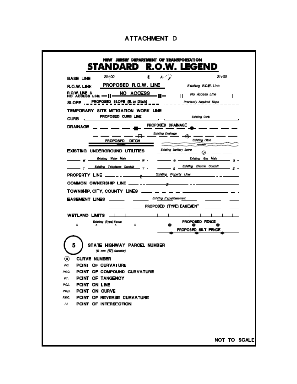
Right of Way Engineering Manual | 75
Attachment D: Standard R.O.W. Legend
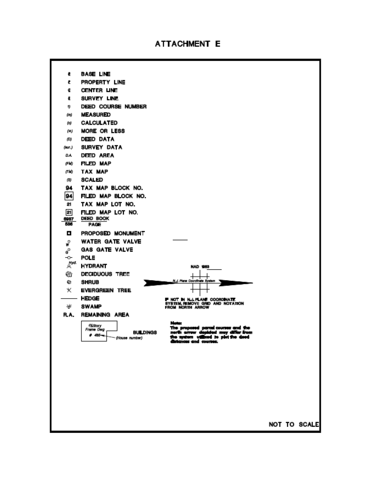
Right of Way Engineering Manual | 76
Attachment E: Standard Legend
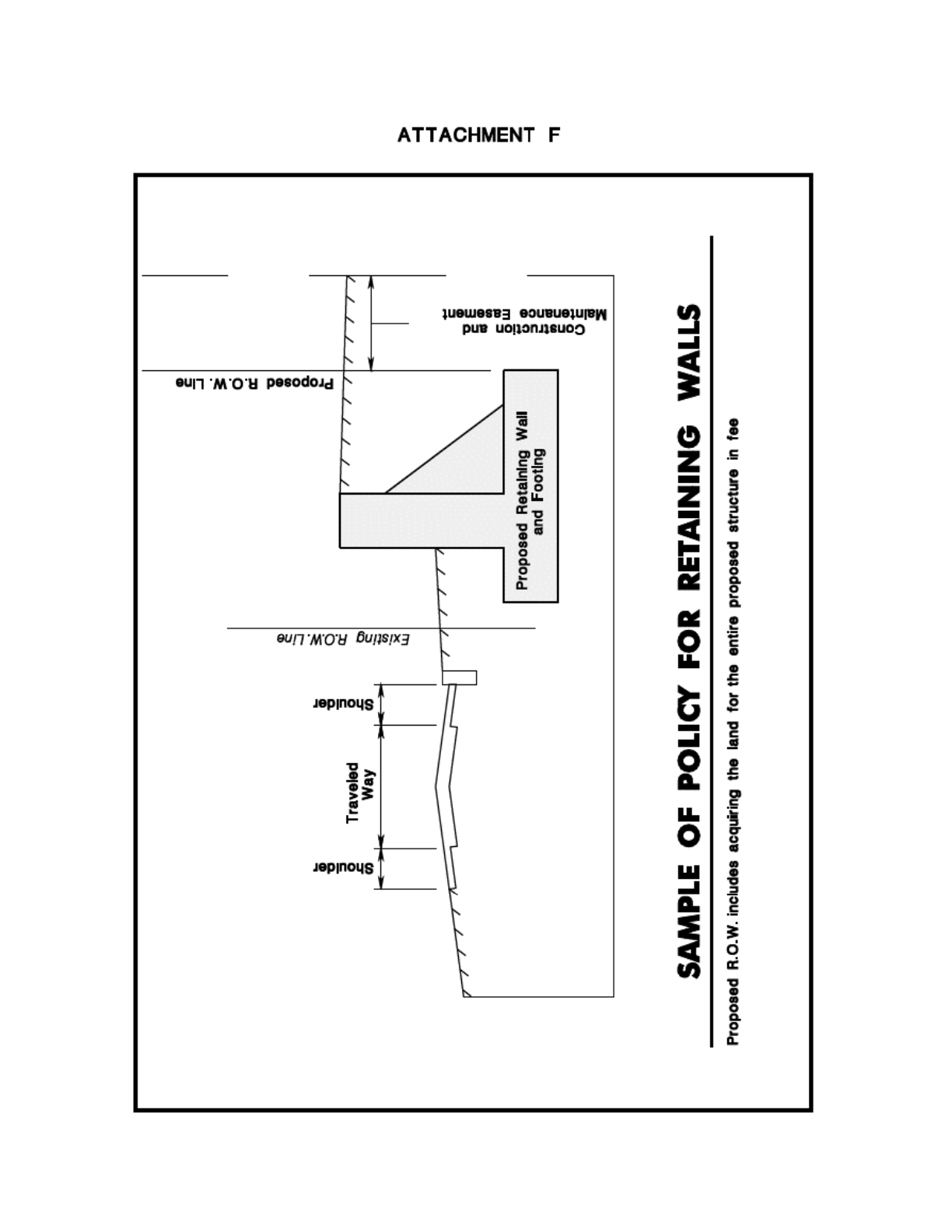
Right of Way Engineering Manual | 77
Attachment F: Sample of Policy for Retaining Walls
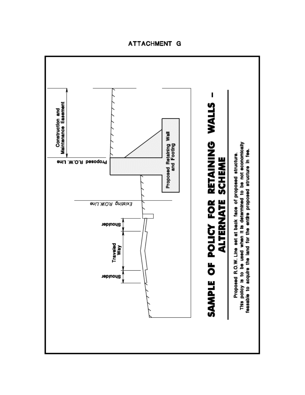
Right of Way Engineering Manual | 78
Attachment G: Sample of Policy for Retaining Walls – Alternate
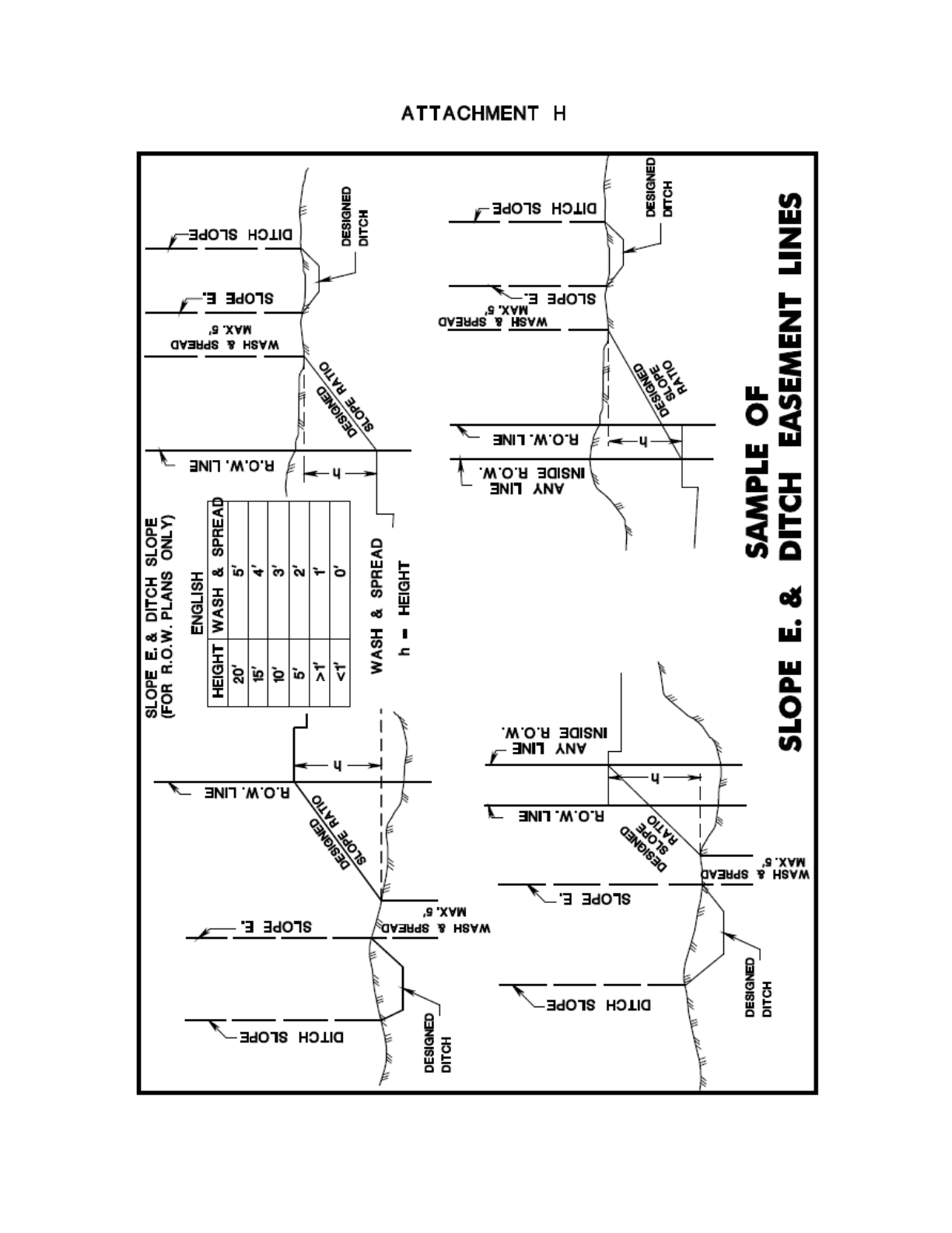
Right of Way Engineering Manual | 79
Attachment H: Sample of Slope E. & Ditch Easement Lines
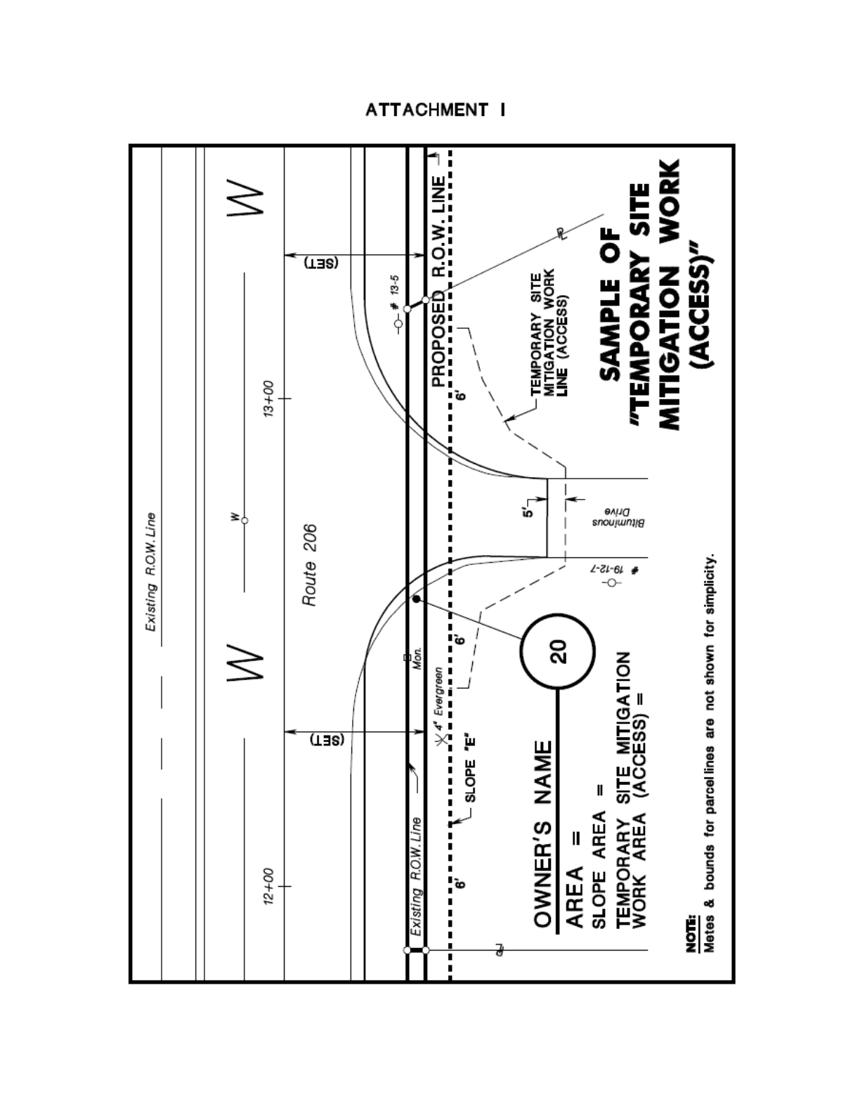
Right of Way Engineering Manual | 80
Attachment I: Sample of “Temporary Site Mitigation Work (Access)”

Right of Way Engineering Manual | 81
Attachment J: Folding Procedure for IPM Prints
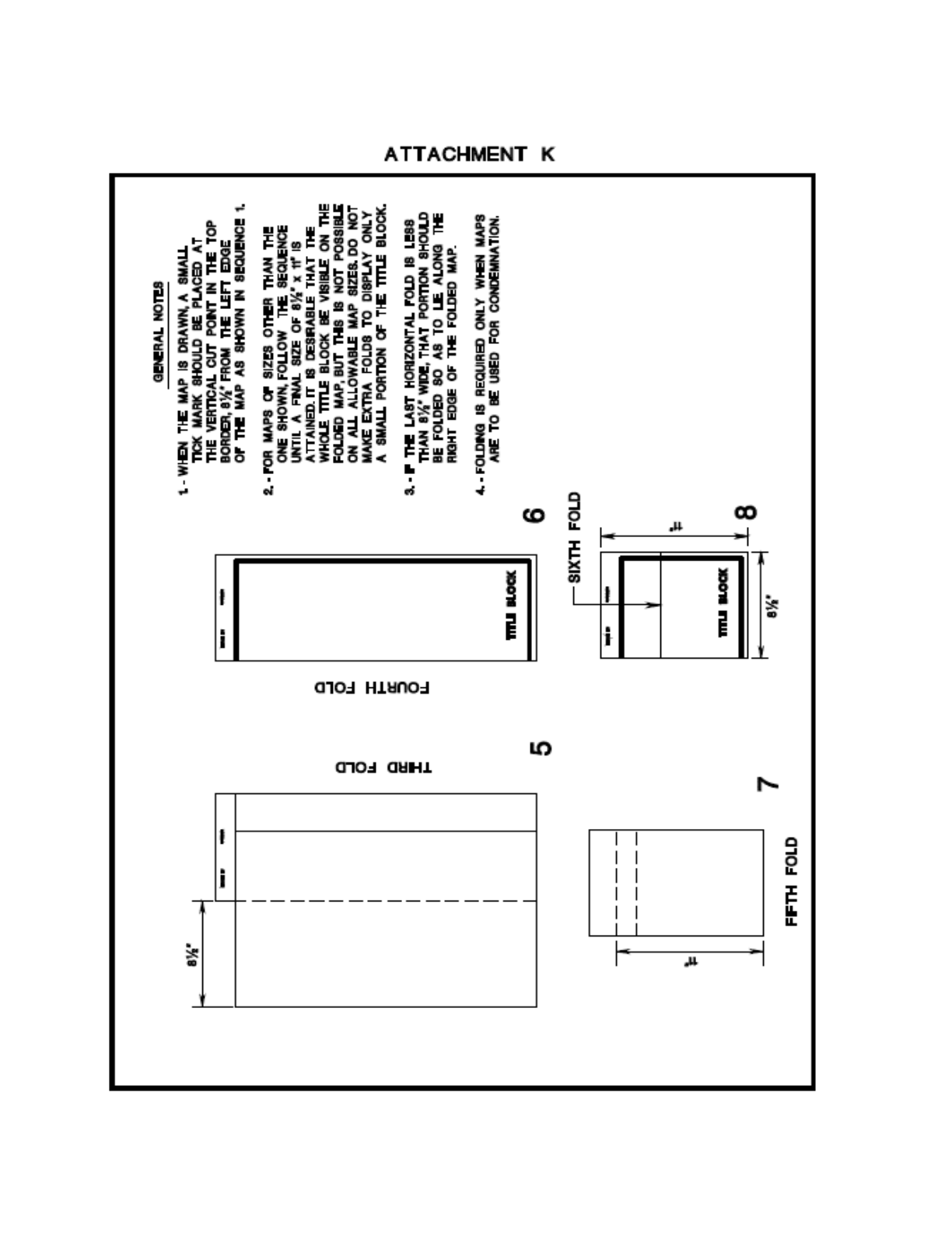
Right of Way Engineering Manual | 82
Attachment K: Folding Procedure for IPM Prints: General Notes
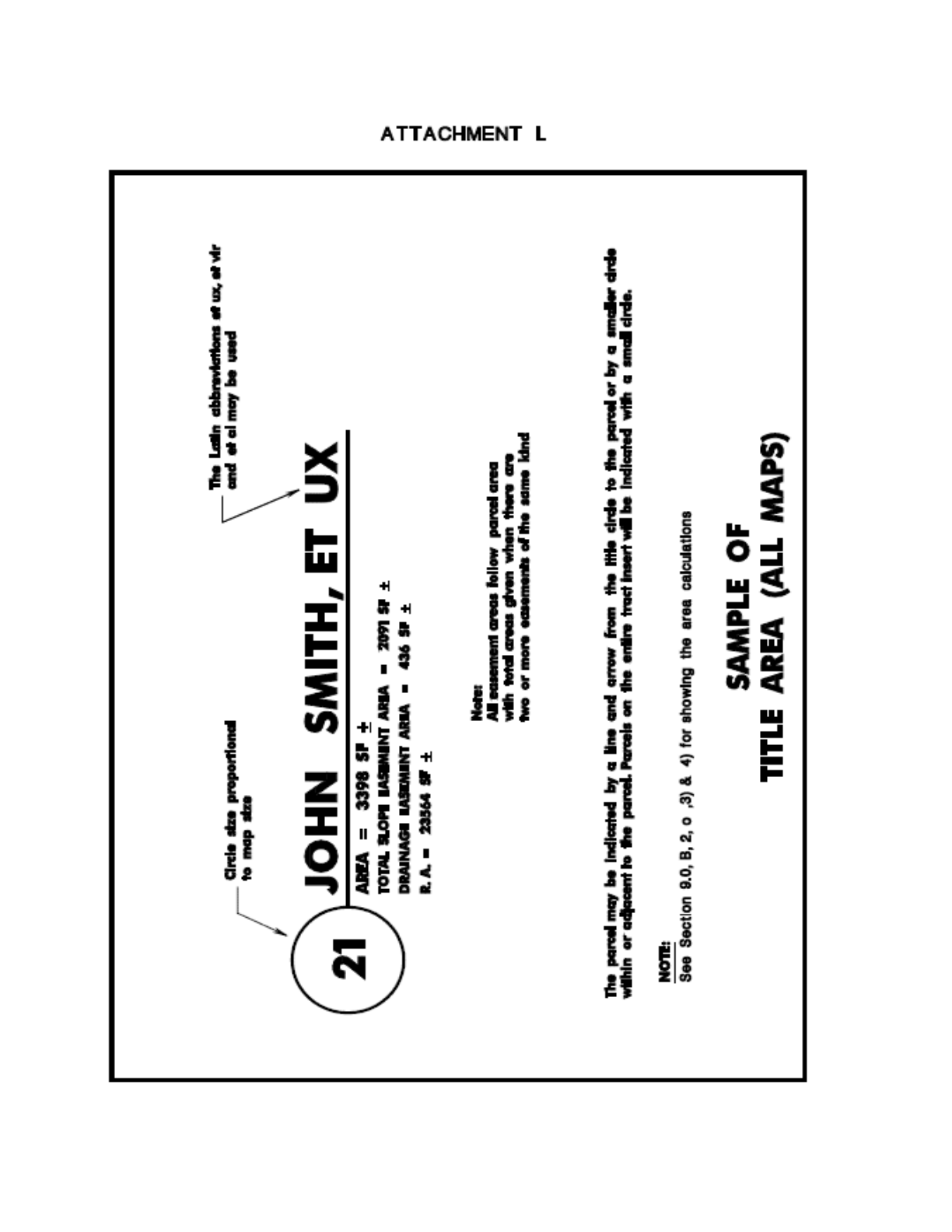
Right of Way Engineering Manual | 83
Attachment L: Sample of Title Area (All Maps)
Right of Way Engineering Manual | 84
Attachment M: Sample of I.P.M. Title Block
Right of Way Engineering Manual | 85
Attachment N: Submissions Requirements Table
LABELED FOR:
PROJECT
COORDINATION
(a)
ROWE
ENG.
WITNESS
TITLE
DISTRICT
ENG.
DOCUMENTS
(b)
LEGAL
FHWA
ENVIRONMENTAL
SOLUTIONS
Documents
(Completed sets)
Submission
Word
PDF
Print
Print
Word
Print
Print
Print
Mylar
TIFF
File
Print
Print
Print
ROW Plans
(GPPMs & ETM)
Prepared in
accordance with
N.J.S.A. 46:26B
1-8 and N.J.A.C.
13:40-5.1.
ROW
IMPACT
PLAN
2
ROW P&D
1
1
1
2
1
1
PRE-FINAL
1
1
FINAL
1
1
2
2
1
1
PROJECT
CLOSED
1
1
3
1
IPMs
In Color coded
correlated sets.
(d), (g) & (h)
ROW P&D
1
1
(c)
1
PRE-FINAL
1
1
FINAL
1
2
9
CONDEMN
(e)
1
2
30
DESCRIPTIONS
(SETS)
ROW P&D
1
1
1
1
PRE-FINAL
1
1
1
FINAL
1
1
CONDEMN
(e)
1
1
CURRENT DEEDS
(IF APPLICABLE)
ROW P&D
1
1
FINAL
(only new)
1
TAX MAPS & SITE
PLANS
ROW P&D
1
FINAL
1
2
1
½ SCALE ROW
PLANS
ROW P&D
1
FINAL
1
1
DESIGN PLANS
ROW P&D
1
1
FINAL
1
1
RIPARIAN
APPLICATION
ROW P&D
1
1
1
FINAL
1
1
1
SIGNED LOAC &
LOLA & STATUS
OF ACCESS CASES
FINAL
1
ACCESS CUTOUTS
FINAL (f)
1
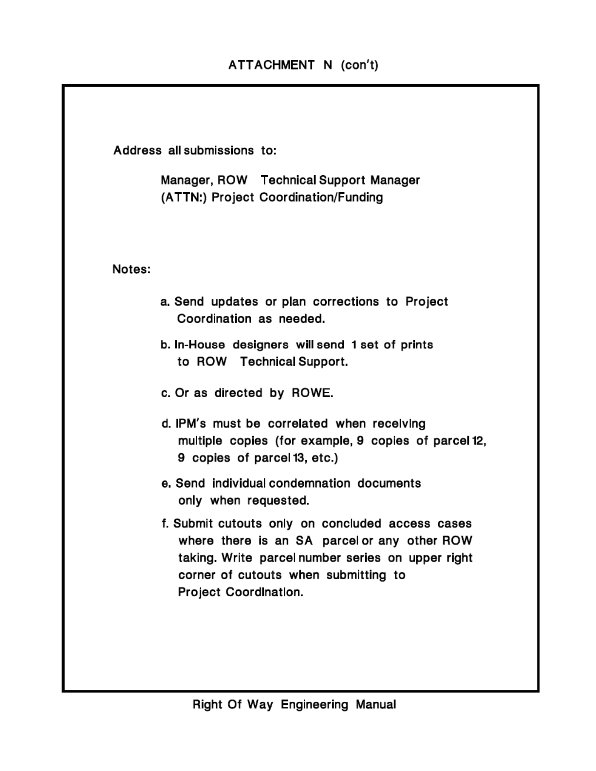
Right of Way Engineering Manual | 86
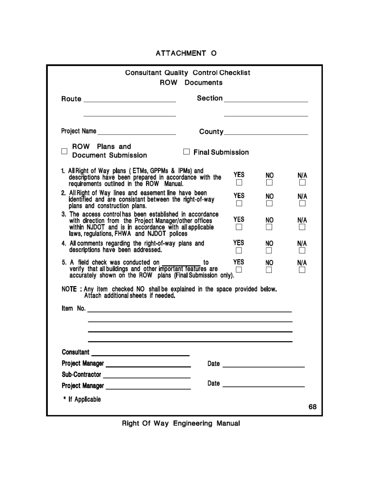
Right of Way Engineering Manual | 87
Attachment O: Consultant Quality Control Checklist

Right of Way Engineering Manual | 88
Attachment P: Title Summary Document

Right of Way Engineering Manual | 89
Attachment Q: Sample of Easement Overlap Area

Right of Way Engineering Manual | 90
Attachment R : Description Samples
Description Samples
Please note that it is acceptable for the language in any description to vary slightly from
what is described in this manual. Also, when preparing easements, the sample language
provided can and should be modified to specify the exact work, and to identify the time
frame required for the temporary easement.
Fee Take
(PI:kk 8/20/20)
All that certain land and premises situate, lying and being in the Township of Carneys
Point, in the County of Salem and the State of New Jersey and more particularly
described as follows:
Parcel 11, as indicated on a map entitled: “NEW JERSEY DEPARTMENT OF
TRANSPORTATION, GENERAL PROPERTY PARCEL MAP, Route 48 (1953) SECTION 1,
From Route US 130, Penn’s Grove to Route US 40, Carneys Point, Showing Existing Right
Of Way And Parcels To Be Acquired In The Borough of Penn’s Grove and Township of
Carneys Point, County of Salem, October 2013”; and as shown more particularly on a
map attached hereto and made a part hereof entitled: “NEW JERSEY DEPARTMENT OF
TRANSPORTATION, ROUTE 48 (1953) SECTION 1, FROM ROUTE US 130, PENNS GROVE
TO ROUTE US 40, CARNEYS POINT, PARCEL 11, TOWNSHIP OF CARNEYS POINT,
COUNTY OF SALEM, OCTOBER 2013”; and also being construction project ROUTE 48
LAYTON LAKE DAM, CONTRACT NO.003023100;
Parcel 11, including specifically all the land and premises located at about 34+30, (Route
48 ROW Base Line Stationing), and more particularly described as follows:
BEGINNING at the intersection of the proposed and the existing right of way line of
Route 48, said point being approximately 80 feet northerly and perpendicular to Route
48 ROW Base Line Station 35+85 and running thence:
1. In a Northwesterly direction along said existing right of way line of Route 48 on a curve
to the right with a radius of 3,920 feet (deed), having an arc distance of 27 feet (scaled)
to the intersection of said existing right of way line of Route 48 and the existing line of
Lakeside Drive.
2. N 66 05’ E (deed), 33 feet (scaled) along said existing line to a point of intersection
with the proposed ROW line of Route 48.
3. N 16 22’ 39.71” W (calculated), 35 feet (scaled) along said proposed line to a point
and place of beginning.
Containing 420 square feet more or less.
Being also known as part of Lots 12 in Block 235 on the tax map of the Township of
Carneys Point, County of Salem.
TOGETHER WITH any ownership, reversionary or associated right, title and interest that
the owner may have in Route 48 and Lakeside Drive, contiguous to the above-described
premises as shown on the aforesaid map.
SUBJECT, HOWEVER, to a 10-foot-wide PSEG Gas Line easement and all other public
utility easements, recorded or unrecorded, affecting the herein described premises.

Right of Way Engineering Manual | 91
The above-described premises are color coded in the following manner: Red – the Fee
Parcel Line.
Fee Take with a Slope Easement and a Temporary Construction Easement
(AOA April 2018)
(PHD March 2019)
All that certain land and premises, situate, lying and being in Township of Cherry Hill, in
the County of Camden and the State of New Jersey and more particularly described as
follows:
Parcel 158, as indicated on a map entitled: "NEW JERSEY DEPARTMENT OF
TRANSPORTATION, GENERAL PROPERTY PARCEL MAP, ROUTE 70 (1953) SECTION 1,
Route 38 To Route 41 (Kings Highway), Showing Existing Right Of Way And Parcels To
Be Acquired In The Townships Of Pennsauken and Cherry Hill, County of Camden, April
2018"; and as shown more particularly on a map attached hereto, made a part thereof,
marked "Exhibit B" entitled: "NEW JERSEY DEPARTMENT OF TRANSPORTATION, ROUTE
70 (1953) SECTION 1, FROM ROUTE 38 To ROUTE 41 (KINGS HIGHWAY), PARCEL 158,
TOWNSHIP OF CHERRY HILL, COUNTY OF CAMDEN, APRIL 2018", and also being
Construction Project Route 70, Route 38 To Cooper Avenue, Contract No. 000113380;
Parcel 158, including specifically all the land and premises located at about Station 167
+ 20 (Route 70 E.B. Base Line Stationing) and more particularly described as follows:
Beginning at a proposed monument in the proposed right of way line of Route 70 (1953),
as laid down on the aforesaid maps, said monument being 40.00 feet southwesterly of
and perpendicular to Base Line Stationing 167 + 80 and running thence.
1. Along said proposed right of way line N 62° 5' 45.80" W (calculated) 114.97 feet
(calculated) to a set point, said point being 40.00 feet southwesterly of and
perpendicular to Base Line Stationing 166 + 65.00, thence.
2. Still along proposed right of way line N 62° 5' 45.80" W (calculated) 72 feet (scaled)
to an intersecting point in the existing division line of Lots 1 and 3, Block 7.01, thence.
3. Along said existing division line N 24° 45' 09" E (deed) 6 feet (scaled) to an intersecting
point in the existing right of way line of Route 70 (1953), thence.
4. Along said existing right of way line S 62° 12' 20" E (deed) 187 feet (scaled) to an
intersecting point in the proposed right of way line of Route 70 (1953), thence.
5. Along said proposed right of way line S 27° 54' 14.20" W (calculated) 6.00 feet
(calculated) to the monument and place of beginning.
Containing 1,130 square feet more or less.
Being also known as part of Lot 3 in Block 7.01 on the tax map of the Township of
Cherry Hill.
TOGETHER WITH, the permanent right, at about Station 167+50 (Route 70 E.B. Baseline
Stationing), to form and maintain slopes for grading the said State roadway as far as the
line marked “Slope E”, as shown on the aforesaid maps, including the right topsoil; seed;
plant trees, vines and shrubs, in such a manner, so as to not interfere with points of
access and to maintain the same so as to support the adjoining roadway; stabilize the
soil, prevent erosion and/or to improve the aesthetic aspects of the roadway, areas of
existing or proposed driveways, parking lots or other paved areas that are to remain in
accordance with the construction plans and specifications for the project, may be

Right of Way Engineering Manual | 92
replaced with equal or better paving or impervious or semi-impervious materials. The
owner shall retain the right to use the area within said slope easement consistent with
the purposes and rights described above, however, the owner shall not have the right to
remove vegetative material, add or remove material from the slope to be constructed,
construct walls or other structures, or in any manner modify said slope easement rights,
without first applying for permission to the New Jersey Department of Transportation
(NJDOT). The permission to modify or release said slope may be obtained from the
NJDOT, Office of ROW, where it is demonstrated by the owner, to the satisfaction of the
NJDOT in its sole discretion, that the slope is no longer needed to support the roadway
or that the proposed modification will not interfere with or adversely affect the integrity
of the slope; the NJDOT, however, reserves the right to impose such terms and
conditions on the release of any slope rights that are necessary to ensure the stability of
the adjacent roadway;
AND ALSO, the temporary right, at about Station 168+70 (Route 70 E.B. Baseline
Stationing), to enter upon the remaining lands of the owner or assigns with personnel,
equipment, and materials to construct sidewalk and appurtenances as far as the line
marked “Temporary Construction Easement Line”, as shown on the aforesaid maps. This
temporary right shall begin from the date of notice from the State’s Resident Engineer,
and shall terminate upon completion of said work, which shall be for a duration of 2
months. If the State, within its sole discretion, determines that the temporary easement
or right needs to be extended to complete the Work, such right may be extended simply
by written notice from the Resident Engineer to the owner or its assigns. In such event
that this temporary right is extended, payment will be made semi-annually during the
extended term of the temporary right, based upon the ‘per-monthly’ rate set forth in the
State’s offer letter.
The location of all permanent easements and improvements constructed therein shall not
be changed or modified in any manner without the specific written permission of the
Division of ROW, New Jersey Department of Transportation within its sole discretion and
upon such terms and conditions as it determines.
AND ALSO, any ownership, reversionary or associated right, title and interest that the
owner may have in Route 70 (1953), contiguous to the above-described premises as
shown on the aforesaid map.
SUBJECT, HOWEVER to all other public utility easements, recorded or unrecorded,
affecting the herein described premises.
The above-described premises are color coded on "Exhibit B" in the following manner:
Red-Fee Parcel Line, Yellow-Slope Easement Line and Brown-Temporary Construction
Easement Line.
Fee Take with Permanent Sidewalk Easement Parcels and Site Mitigation
Parcels
(FDR, hh, 9/30/19)
All that certain land and premises, situate, lying and being in the Township of Haddon, in
the County of Camden and State of New Jersey and particularly described as follows:
Parcels 100A, E100B, E100C, SR100D and SR100F, as indicated on a map entitled: “NEW
JERSEY DEPARTMENT OF TRANSPORTATION, GENERAL PROPERTY PARCEL MAP, ROUTE
168 (1953) SECTION 2, Ferry Avenue To Evesham Road, Showing Existing Right Of Way
And Parcels To Be Acquired In City Of Camden, Township Of Haddon, And Boroughs Of

Right of Way Engineering Manual | 93
Woodlynne, Oaklyn, Audubon Park, Audubon, Mount Ephraim, Haddon Heights,
Bellmawr, And Runnemede, County of Camden, March 2019”; and as shown more
particularly on a map attached hereto, made a part hereof, marked “Exhibit B” entitled:
“NEW JERSEY DEPARTMENT OF TRANSPORTATION, ROUTE 168 (1953) SECTION 2, Ferry
Avenue To Evesham Road, PARCELS 100A, E100B, E100C, SR100D & SR100F, Township
Of Haddon, County Of Camden, March 2019”; and also being construction project RT
168, MERCHANT STREET TO FERRY AVENUE, CONTRACT NO. 0100103410;
Parcel 100A, including specifically all the land and premises located at about Station
56+40 [Base Line Route 168 (1953) Stationing], and more particularly described as
follows:
BEGINNING at a point in the proposed northeasterly right of way line of Route 168
(a.k.a. Mount Ephraim Avenue) where the same is intersected by the southeasterly line
of Walnut Avenue said point being 39.00 feet northeastwardly and normal from about
Station 56+32 Base Line Route 168 (1953) Stationing, and from said beginning point
runs, thence:
1. Along said proposed northeasterly right of way line, through the lands of the grantor
herein (Block 2.08, Lot 9), S17°54’14” E (calculated), 13' (scaled), to a point and corner
to the same, being 39.00 feet northeastwardly and normal from the aforementioned
Base Line at Station 56+45.00 (calculated), as laid down on the aforesaid maps.
2. Still along said proposed northeasterly right of way line, through the lands of the
grantor herein (Block 2.08, Lot 9), S72°05’46” W (calculated), 6’ (scaled), to a point
in the existing northeasterly right of way line of the aforementioned Route 168, as laid
down on the aforesaid maps.
3. Along the existing northeasterly right of way line, N10°27’34” W (deed), 12’ (scaled),
to a point in the aforementioned southeasterly line of Walnut Avenue
4. Along said southeasterly line, N73°35’41” E (deed), 6’ (scaled), to the point and place
of beginning.
Containing 80 Square Feet, more or less.
Being also known as part of Lot 9 in Block 2.08 on the Township of Haddon Tax Maps.
Parcel E100B, at about Station 58+90 [Base Line Route 168 (1953) Stationing],
consisting of the permanent right to enter upon the lands of the owner or its assigns
within the Permanent Sidewalk Easement area with personnel, equipment, and materials
for the following purposes:
• To reconstruct existing public use sidewalk and to reconstruct sidewalk related
appurtenances at the locations shown on the aforesaid map to the extent
needed to meet ADA requirements.
• To grade a supporting slope to support the sidewalk work.
The right to enter and to perform the work set forth above extends as far as the line
marked “PERMANENT Sidewalk Easement LINE” as shown on the aforesaid maps. All
proposed changes and improvements will be constructed as illustrated on the aforesaid
maps.
At the completion of the sidewalk construction work for the above parcel, any disturbed
ground will be restored by regrading, adding topsoil and reseeding.

Right of Way Engineering Manual | 94
The owner or its assigns shall have responsibility for maintenance of the sidewalk upon
completion of the work in accordance with law.
Being also known as a permanent easement in Lot 10 in Block 2.08 on the Township of
Haddon Tax Maps.
Parcel E100C, at about Station 59+30 [Base Line Route 168 (1953) Stationing],
consisting of the permanent right to enter upon the lands of the owner or its assigns
within the Permanent Sidewalk Easement area with personnel, equipment, and materials
for the following purposes:
• To reconstruct existing public use sidewalk and to reconstruct sidewalk related
appurtenances to the extent needed to meet ADA requirements.at the locations
shown on the aforesaid map.
• To re-grade the existing driveway.
The right to enter and to perform the work set forth above extends as far as the
line marked “PERMANENT Sidewalk Easement LINE” as shown on the aforesaid maps. All
proposed changes and improvements will be constructed as illustrated on the aforesaid
maps.
At the completion of the sidewalk construction work for the above parcel, any disturbed
ground will be restored by regrading, adding topsoil and reseeding.
The owner or its assigns shall have responsibility for maintenance of the sidewalk upon
completion of the work in accordance with law.
Being also known as a permanent easement in Lot 15 in Block 2.08 on the Township of
Haddon Tax Maps;
The location of all permanent easements and improvements constructed therein shall not
be changed or modified in any manner without the specific written permission of the
Division of ROW, New Jersey Department of Transportation within its sole discretion and
upon such terms and conditions as it determines.
Parcel SR100D, at about Station 57+20 [Base Line Route168 (1953) Stationing],
consisting of the temporary right to enter upon the remaining lands of the owner with
personnel, material and equipment for the purpose of implementing mitigation work in
kind, consisting of regrading and paving a driveway, constructing concrete
pavement/sidewalk, which may otherwise emanate from the proposed acquisition of
Parcel SR100D and or other lesser rights for a proposed transportation project, as far as
the line marked “TEMPORARY SITE MITIGATION WORK LINE”, as shown on the aforesaid
map. This right shall begin from the date of notice from the State’s Resident Engineer,
and shall terminate upon the completion of the work, after which the improvements
constructed shall become the property and responsibility of the owner, its successors
and assigns
Being also known as a temporary easement in Lot 9 in Block 2.08 on the Township of
Haddon Tax Maps.
Parcel SR100F, at about Station 59+20 [Base Line Route168 (1953) Stationing],
consisting of the temporary right to enter upon the remaining lands of the owner with
personnel, material and equipment for the purpose of implementing mitigation work in
kind, consisting of regrading and paving a driveway, constructing concrete
pavement/sidewalk, which may otherwise emanate from the proposed acquisition of

Right of Way Engineering Manual | 95
Parcel SR100F and or other lesser rights for a proposed transportation project, as far as
the line marked “TEMPORARY SITE MITIGATION WORK LINE”, as shown on the aforesaid
map. This right shall begin from the date of notice from the State’s Resident Engineer,
and shall terminate upon the completion of the work, after which the improvements
constructed shall become the property and responsibility of the owner, its successors
and assigns
Being also known as a temporary easement in Lots 10 & 15 in Block 2.08 on the
Township of Haddon Tax Maps.
TOGETHER WITH any ownership, reversionary or associated right, title and interest that
the owner may have in the right of ways of Route 168 (1953) (a.k.a. Mount Ephraim
Avenue) and Walnut Avenue, as shown on the aforesaid maps.
SUBJECT, HOWEVER, to all public utility easements, recorded or unrecorded, affecting
the herein described premises.
The above-described premises are color-coded on “EXHIBIT B” in the following man RED
- FEE PARCEL LINE; BROWN – PERMANENT SIDEWALK EASEMENT LINE; TEMPORARY
SITE MITIGATION WORK LINE.
Temporary Construction Easement
(KG; pai 04/10/20)
An easement in certain lands situate, lying and being in the Borough of Butler, County of
Morris and State of New Jersey and more particularly described as follows:
Parcel E275, as shown on a map attached hereto and made a part hereof, marked
“Exhibit B”, entitled “NEW JERSEY DEPARTMENT OF TRANSPORTATION, ROUTE U.S. 23
(1953) SECTION 3, Black Oak Ridge to Paterson Hamburg Turnpike, PARCEL E275,
Borough of Butler, County of Morris, March 2020”; and also, being construction project
ROUTE 23 ALEXANDER ROAD TO MAPLE LAKE ROAD, CONTRACT NO. 017114240.
Parcel E275 at about Baseline Station 545+10 (Existing Route 23 Baseline Stationing),
consisting of the temporary right to enter upon the remaining lands of the owner or its
assigns with personnel, equipment, and materials for the purpose of removing the
existing guiderail and appurtenances and for top soiling, seeding, and mulching as far as
the line marked “Temporary Construction Easement Line”, as shown on the aforesaid
maps. This temporary right shall begin from the date of notice from the State’s Resident
Engineer, and shall terminate upon completion of said work, which shall be for a duration
of 2 weeks. If the State, within its sole discretion, determines that the temporary
easement or right needs to be extended to complete the work, such right may be
extended simply by written notice from the Resident Engineer to the owner or its
assigns. In such event that this temporary right is extended, payment will be made
semi-annually during the extended term of the temporary right, based upon the ‘per-
monthly’ rate set forth in the State’s offer letter.
Being also known as a temporary easement in Lot 2 in Block 203 on the tax map of the
Borough of Butler.
The above-described premises are color coded on “Exhibit B” in the following manner:
Brown –Temporary Construction Easement Line.
Temporary Sidewalk Work Area
(IM; gvr, 7/30/20)

Right of Way Engineering Manual | 96
A Temporary Sidewalk Work Area in certain lands situate, lying and being in the
Township of Cedar, County of Essex and State of New Jersey and more particularly
described as follows:
Parcel E26 as indicated on a map entitled: “NEW JERSEY DEPARTMENT OF
TRANSPORTATION, GENERAL PROPERTY PARCEL MAP, ROUTE 23 (1953) SECTION 1,
Verona To Passaic County Line, Showing Existing Right Of Way And Parcels To Be
Acquired In The Townships Of Verona And Cedar Grove, County Of Essex, June 2017";
and as shown more particularly on a map attached hereto, made a part hereof, marked
“Exhibit B” entitled: “NEW JERSEY DEPARTMENT OF TRANSPORTATION, ROUTE 23
(1953) SECTION 1, Verona To Passaic County Line; PARCEL E26, TOWNSHIP OF CEDAR
GROVE, COUNTY OF ESSEX, JUNE 2017"; and also being Construction Project ROUTE 23
BLOOMFIELD AVENUE TO BRIDGE OVER NJ TRANSIT;
Parcel E26, at about Station 189+20 (Route 23 Baseline Stationing), consisting of the
temporary right to enter upon the lands of the owner or its assigns with personnel,
equipment, and materials for the purpose of reconstructing existing public use sidewalk
and to re-grade any asphalt areas which are directly impacted by the sidewalk work to
the extent needed to properly connect with the public use sidewalk and meet ADA
requirements as far as the line marked “Temporary Sidewalk Work Line”, as shown on
the aforesaid maps. This right shall begin from the date of notice from the State’s
Resident Engineer, which will be for a duration of 2 months. If the State, within its sole
discretion, determines that the temporary easement or right needs to be extended in
order to complete the work, such right may be extended simply by written notice from
the Resident Engineer to the owner or its assigns. In such event that this temporary
right is extended, payment will be made semi-annually during the extended term of the
temporary right, based upon the per-monthly rate set forth in the State’s offer letter. At
the completion of the sidewalk construction work, any disturbed ground will be restored
by regrading, adding topsoil and reseeding. This right shall terminate when all work is
completed.
The owner or its assigns shall have responsibility for maintenance of the sidewalk upon
completion of the work in accordance with law.
Being also known as a Temporary Sidewalk Work Area in Lot 33 in Block 120, Tax Map of
the Township of Cedar Grove, County of Essex.
SUBJECT, HOWEVER, to all public utility easements, recorded or unrecorded, affecting
the herein described premises.
The above-described premises are color-coded “Exhibit B” in the following manner:
Brown – Temporary Sidewalk Work Line.
Permanent Sidewalk Easement with a Contiguous Temporary Sidewalk Work
Area
(PI; ct, 9/12/20)
Easements in certain land and premises situate, lying and being in the Township of
Verona, in the County of Essex and State of New Jersey and particularly described as
follows:
Parcels E21 as indicated on a map entitled: “NEW JERSEY DEPARTMENT OF
TRANSPORTATION, GENERAL PROPERTY PARCEL MAP, ROUTE 23 (1953) SECTION 1,
Verona To Passaic County Line, Showing Existing Right Of Way And Parcels To Be
Acquired In The Townships Of Verona And Cedar Grove, County Of Essex, June 2017";

Right of Way Engineering Manual | 97
and as shown more particularly on a map attached hereto, made a part hereof, marked
“Exhibit B” entitled: “NEW JERSEY DEPARTMENT OF TRANSPORTATION, ROUTE 23
(1953) SECTION 1, Verona To Passaic County Line; PARCEL E21, TOWNSHIP OF
VERONA, COUNTY OF ESSEX, JUNE 2017"; and also being Construction Project ROUTE
23 BLOOMFIELD AVENUE TO BRIDGE OVER NJ TRANSIT;
Parcels E21, at about Station 108+70 (Route 23 Baseline Stationing), consisting of the
permanent right to enter upon the lands of the owner or its assigns within the
Permanent Sidewalk Easement with personnel, equipment, and materials for the
following purposes:
• To construct new or reconstruct existing public use sidewalk and to reconstruct
sidewalk related appurtenances at the locations shown on the aforesaid map to
the extent needed to meet ADA requirements.
• To grade a supporting slope to support the sidewalk work.
The right to enter and to perform the work set forth above extends as far as the line
marked “PERMANENT Sidewalk Easement LINE” as shown on the aforesaid maps. All
proposed changes and improvements will be constructed as illustrated on the aforesaid
maps.
The location of all permanent easements and improvements constructed therein shall not
be changed or modified in any manner without the specific written permission of the
Division of ROW, New Jersey Department of Transportation within its sole discretion and
upon such terms and conditions as it determines.
TOGETHER WITH consisting of the temporary right to enter upon the lands of the owner
or its assigns within the Temporary Sidewalk Work Area with personnel, equipment, and
materials for the following purposes:
• To repair existing public use sidewalk
• To regrade existing driveways
This right shall begin from the date of notice from the State’s Resident Engineer, which
will be for a duration of 2 months. If the State, within its sole discretion, determines that
the temporary easement or right needs to be extended to complete the work, such right
may be extended simply by written notice from the Resident Engineer to the owner or its
assigns. In such event this temporary right is extended, payment will be made semi-
annually during the extended term of the temporary right, based upon the per-monthly
rate set forth in the State’s offer letter. This right shall terminate when all work is
completed.
At the completion of the sidewalk construction work, any disturbed ground will be
restored by regrading, adding topsoil and reseeding.
The owner or its assigns shall have responsibility for maintenance of the sidewalk upon
completion of the work in accordance with law.
Being also known as a Permanent Sidewalk Easement and a Temporary Sidewalk
Easement in Lot 1 in Block 207, Tax Map of the Township of Verona, County of Essex.
SUBJECT, HOWEVER, to all public utility easements, recorded or unrecorded, affecting
the herein described premises.

Right of Way Engineering Manual | 98
The above-described premises are color-coded “Exhibit B” in the following manner:
Brown – Permanent Sidewalk Easement Line and Brown – Temporary Sidewalk Work
Line.
Permanent Sidewalk Easement
(PI;cq 7/22/20)
An Easement in certain land and premises situate, lying and being in the Township of
Verona, in the County of Essex and State of New Jersey and particularly described as
follows:
Parcel E19 as indicated on a map entitled: “NEW JERSEY DEPARTMENT OF
TRANSPORTATION, GENERAL PROPERTY PARCEL MAP, ROUTE 23 (1953) SECTION 1,
Verona To Passaic County Line, Showing Existing Right Of Way And Parcels To Be
Acquired In The Townships Of Verona And Cedar Grove, County Of Essex, June 2017";
and as shown more particularly on a map attached hereto, made a part hereof, marked
“Exhibit B” entitled: “NEW JERSEY DEPARTMENT OF TRANSPORTATION, ROUTE 23
(1953) SECTION 1, Verona To Passaic County Line; PARCEL E19, TOWNSHIP OF
VERONA, COUNTY OF ESSEX, JUNE 2017"; and also being Construction Project ROUTE
23 BLOOMFIELD AVENUE TO BRIDGE OVER NJ TRANSIT;
Parcel E19 consisting of a right to enter upon the lands of the owner or its assigns with
personnel, equipment, and materials for the purpose of construct new public use
sidewalk and to related appurtenances to the extent needed to meet ADA requirements
as far as the line marked “Permanent Sidewalk Easement”, as shown on the aforesaid
maps. At the completion of the sidewalk construction work, any disturbed ground will be
restored in by regrading, adding topsoil and reseeding.
The owner or its assigns shall resume responsibility for maintenance of the sidewalk
upon completion of the work in accordance with law.
The location of all permanent easements and improvements constructed therein shall not
be changed or modified in any manner without the specific written permission of the
Division of ROW, New Jersey Department of Transportation within its sole discretion and
upon such terms and conditions as it determines.
Being also known as an Easement in Lot 1 in Block 206, Tax Map of the Township of
Verona, County of Essex.
SUBJECT, HOWEVER, to all public utility easements, recorded or unrecorded, affecting
the herein described premises.
The above-described premises are color-coded “Exhibit B” in the following manner:
Brown – Permanent Sidewalk Easement Line.
Fee Take with a Temporary Construction Easement and Temporary Site
Mitigation (Access)
All that certain land and premises, situate, lying and being in the Township of Winslow,
in the County of Camden and the State of New Jersey and being more particularly
described as follows:
Parcels 40A and SA40B as indicated on a map entitled: “NEW JERSEY DEPARTMENT OF
TRANSPORTATION, GENERAL PROPERTY PARCEL MAP, ROUTE U.S. 30 (1953), SECTION
11, Atlantic-Camden County Line To Waterford Road, Showing Existing Right Of Way And
Parcels To Be Acquired In The Township of Winslow, County of Camden, May 2011”; and

Right of Way Engineering Manual | 99
as shown more particularly on a map attached hereto and made a part hereof, marked
“EXHIBIT B”, entitled “NEW JERSEY DEPARTMENT OF TRANSPORTATION ROUTE U.S. 30
(1953), SECTION 11, Atlantic-Camden County Line To Waterford Road, PARCELS 40A &
SA40B, TOWNSHIP OF WINSLOW, CAMDEN COUNTY, MAY 2011”, and also being
construction project RT. 30 BLUE ANCHOR DAM, CONTRACT NO. 026950292;
Parcel 40A, including specifically all the land and premises located at about Station
129+00 [Base Line Route U.S. 30 (1953) Stationing], and being more particularly
described as follows:
BEGINNING at a point in the proposed northeasterly right of way line of Route U.S. 30
(1953) (a.k.a. White Horse Pike), where the same is intersected by the division line
between lands of the grantor herein (Block 6601, Lot 20) and lands now or formerly of
Garden State Vegetable Co., Inc. (Block 6601, Lot 19.05), at about Base Line Station
129+77, and from said beginning point runs, thence:
1. Through lands of the grantor herein and along the proposed northeasterly right of way
line of Route U.S. 30, S39°49’51” E (calculated), 38.00 feet northeastwardly and
normal from said Base Line, 150 feet (scaled) to a point where the same is intersected
by the division line between lands of the grantor herein and lands now or formerly of
Joseph Gallo (Block 6601, Lot 21), as laid down on the aforesaid maps.
2. Along said division line between lands of the grantor herein and Lot 21, S42°42’00” W
(deed), 5 feet (scaled) to a point where the same is intersected by the existing
northeasterly right of way line of Route U.S. 30 (1953) (a.k.a. White Horse Pike).
3. Along said existing northeasterly right of way line of Route U.S. 30, N47°18’00” W
(deed), 150.00 feet (deed) to a point where the same is intersected by the
aforementioned division line between lands of the grantor herein and Lot 19.05.
4. Along said division line between lands of the grantor herein and Lot 19.05, N42°42’00”
E (deed), 5 feet (scaled) to the point and place of beginning.
Containing 750 square feet, more or less.
Being also known as part of Lot 20 in Block 6601 on the Township of Winslow Tax Maps.
TOGETHER WITH at about Station 129+45 [Base Line Route U.S. 30 (1953) Stationing],
consisting of the temporary right to enter upon the remaining lands of the owner or its
assigns with personnel, equipment, and materials for the purpose of installing proposed
traffic signals and appurtenances within the State’s ROW and also for top soiling, seeding
and mulching as far as the line marked “Temporary Construction Easement Line”, as
shown on the aforesaid maps. This temporary right shall begin from the date of notice
from the State’s Resident Engineer, and shall terminate upon completion of said work,
which shall be for a duration of 3 weeks. If the State, within its sole discretion,
determines that the temporary easement or right needs to be extended to complete the
work, such right may be extended simply by written notice from the Resident Engineer
to the owner or its assigns. In such event that this temporary right is extended, payment
will be made semi-annually during the extended term of the temporary right, based upon
the ‘per-monthly’ rate set forth in the State’s offer letter.
Parcel SA40B, at about Station 129+00 [Base Line Route U.S. 30 (1953) Stationing],
consisting of the temporary right to enter upon the remaining lands of the owner with
personnel, material, and equipment for the purpose of implementing the mandates of
N.J.S.A. 27:7-94(d) pursuant to an access proceeding by the Commissioner of
Transportation. The access proceeding involved a modification of driveway and requires

Right of Way Engineering Manual | 100
providing all necessary assistance to the property owner in establishing reasonable
access to the general system of streets and highways. The assistance includes providing
improvements constructed in kind, consisting of paving two driveways, grading, top
soiling and seeding. This temporary right shall extend as far as the line marked
“Temporary Site Mitigation Work Line (Access)”, as shown on the aforesaid maps. This
right shall begin from the date of notice from the State’s Resident Engineer, and shall
terminate upon the completion of the work, after which the improvements constructed
shall become the property and responsibility of the owner, its successors and assigns.
AND ALSO, any ownership, reversionary or associated right, title and interest that the
owner may have in the right of way of Route U.S. 30 (1953), as shown on the aforesaid
maps.
SUBJECT, HOWEVER, to all public utility easements, recorded or unrecorded, affecting
the herein described premises.
The above-described premises are color-coded on “EXHIBIT B” in the following manner:
Red–Fee Parcel Line; BROWN–TEMPORARY SITE MITIGATION WORK LINE (ACCESS).
Temporary Denial of Access Easement and a Temporary Access Right
04/22/19 (PAI:ok)
A temporary access easement in certain land and premises, situated, lying and being in
the Township of Vernon, in the County of Sussex, and the State of New Jersey and more
particularly described as follows:
Parcel TDA7C, as indicated on a map entitled: “NEW JERSEY DEPARTMENT OF
TRANSPORTATION, GENERAL PROPERTY PARCEL MAP, ROUTE 94 (1953) SECTION 9,
From McAfee Road to Vernon Stockholm Road, Showing Existing Right Of Way and
Parcels To Be Acquired In The Township Of Vernon, County Of Sussex, March 2011”; and
as shown more particularly on a map attached hereto and made a part hereof, marked
“Exhibit B”, entitled: “NEW JERSEY DEPARTMENT OF TRANSPORTATION, ROUTE 94
(1953) SECTION 9, From McAfee Road to Vernon Stockholm Road, PARCEL TDA7C,
TOWNSHIP OF VERNON, COUNTY OF SUSSEX, MARCH 2011”; and also being
CONSTRUCTION PROJECT: ROUTE 94 BLACK CREEK TRIBUTARY, CULVERT
REPLACEMENT, CONTRACT No. 039103830;
Parcel TDA7C, the temporary right at about Station 100+64 Lt. (State Route 94 Base
Line Stationing) to close the owner’s driveway and an additional temporary right at
about Station 101+47 Lt. (State Route 94 Base Line Stationing), to close the owner’s
driveway, utilized by the Sussex County MUA as a permanent easement holder on the
property, to vehicular and pedestrian traffic as shown on the aforesaid maps. Including
the temporary right at about Station 99+60 Lt. (State Route 94 Base Line Stationing), to
enter upon the remaining lands of the owner or assigns with personnel, equipment, and
materials to construct bituminous pavement parking areas and install a temporary chain-
link pedestrian gate in an existing chain-link fence as shown on the attached Exhibit B.
The temporary chain-link pedestrian gate will be removed, and the chain-link fence will
be restored to its original condition upon completion of construction, all other bituminous
paving shall remain in place for the benefit of the owner, including a total of 1 parking
space for the benefit of the permanent easement holder (Sussex County Municipal
Utilities Authority), as shown on the aforesaid maps. This temporary right shall be
binding upon the owner’s heirs or assigns. The temporary right shall begin from the date
of notice from the State’s Resident Engineer, and shall terminate upon completion of said

Right of Way Engineering Manual | 101
work, which shall be for a duration of 4 months. If the State, within its sole discretion,
determines that the temporary right needs to be extended to complete the work, such
right may be extended simply by written notice from the Resident Engineer to the owner
or its assigns. In such event that this temporary right is extended, payment will be made
semi-annually during the extended term of the temporary right, based upon the ‘per-
monthly’ rate set forth in the State’s offer letter.”
TOGETHER WITH the temporary right at about Station 99+60 Lt. (State Route 94 Base
Line Stationing), consisting of the temporary, nonexclusive right of ingress and egress
for the owners, successors and assigns, permanent easement holders (Sussex County
Municipal Utilities Authority), as well as business invitees and guests (to the extent
permitted by the owner) of Lot 12 Block 231, Township of Vernon, County of Sussex,
across lands of Mountain Creek Resorts, in Lot 12 Block 231, as far as the line marked
“TEMPORARY ACCESS EASEMENT LINE”, as shown on the aforesaid maps; maintenance
shall be the responsibility of the owner of Lot 12 Block 231 as far as the line marked
“TEMPORARY ACCESS EASEMENT LINE”, as shown on the aforesaid maps.”
Being also known as an easement in Lot 12 Block 231 on the tax map of the Township of
Vernon, Sussex County, Sheet No’s 19.09, 23 and 23.08, Dated Jan. 1994.
Tidelands Easement
A tidelands easement in the Borough of Lavallette, in the County of Ocean and the State
of New Jersey and more particularly described as follows:
Parcel TE80F as indicated on a map entitled: "NEW JERSEY DEPARTMENT OF
TRANSPORTATION, GENERAL PROPERTY PARCEL MAP, ROUTE U.S. 35 (1953), SECTION
2, Seaside Heights To Point Pleasant, Showing Existing Right Of Way And Parcels To Be
Acquired In The Boroughs of Seaside Heights, Lavallette, Mantoloking, Bay Head, Point
Pleasant Beach And Point Pleasant And In The Townships of Toms River And Brick,
County Of Ocean, March 2013"; and as shown more particularly on a map attached
hereto and made a part hereof, marked "Exhibit B," entitled "NEW JERSEY DEPARTMENT
OF TRANSPORTATION, ROUTE U.S. 35 (1953) SECTION 2, SEASIDE HEIGHTS TO POINT
PLEASANT, PARCEL TE80F, BOROUGH OF LAVALLETTE, COUNTY OF OCEAN, MARCH
2013";
Parcel TE80F, located at about Station 209+65 (Bay Boulevard Baseline Stationing),
consisting of the permanent right to access, construct, reconstruct and maintain
subsurface drains, rip rap bulkheads and appurtenances as far as the line marked
“Drainage Easement Line”, as shown on the aforesaid maps. The drainage improvements
shown are for illustration purposes only. The State reserves the right to place all
drainage improvements as far as the line marked “Drainage Easement Line”, as shown
on the aforesaid maps.
Being also known as an easement in tidelands adjacent to Jersey City Avenue between
Blocks 65 and 66 on the tax map of the Borough of Lavallette.
The location of all permanent easements and improvements constructed therein shall not
be changed or modified in any manner without the specific written permission of the
Division of ROW, New Jersey Department of Transportation within its sole discretion and
upon such terms and conditions as it determines. All the work to be done inside the
easement areas.
SUBJECT, HOWEVER, to all public utility easements, recorded or unrecorded, affecting
the herein described premises.

Right of Way Engineering Manual | 102
The above-described premises are color coded on "Exhibit B" in the following manner:
Green – Drainage Easement Line.
Tidelands Parcels with a Bridge Easement and Temporary Construction
Easement
Notes: Consult with the Tideland Bureau at DEP before finalizing descriptions involving
Tidelands. Parcel T51M is a conveyance of area to be filled or built over as part of the
Project
(WS:sp, 4-13-16)
All that certain lands and premises, situate, lying and being in the Township of Stafford
and the Borough of Ship Bottom, in the County of Ocean and State of New Jersey, more
particularly described as follows:
PARCELS T51M, TE51N & TE51O, as indicated on a map entitled: "NEW JERSEY
DEPARTMENT OF TRANSPORTATION, GENERAL PROPERTY PARCEL MAP, ROUTE 72
(1953) SECTION 7, ROUTE U.S. 9 TO BRIDGE OVER MANAHAWKIN BAY, Showing
Existing Right Of Way And Parcels To Be Acquired In The Township of Stafford & Borough
of Ship Bottom, County Of Ocean, April, 2010"; And as shown more particularly on a
map attached hereto, marked “Exhibit B”, entitled “NEW JERSEY DEPARTMENT OF
TRANSPORTATION, Route 72 (1953) SECTION 7, ROUTE U.S. 9 TO BRIDGE OVER
MANAHAWKIN BAY, TIDELANDS PARCEL MAP - PARCELS T51M, TE51N & TE51O
TOWNSHIP OF STAFFORD, COUNTY OF OCEAN, NOVEMBER, 2010"; And also being
construction project Route 72 Manahawkin Bay Bridges, CONTRACT NO. 025113850,
026118012, 026118013, & 026118014;
Parcel T51M, including specifically all the land and premises located at about Station
568+10 Proposed Route 72 EB Baseline Stationing, and more particularly as follows:
BEGINNING at a point on the proposed southwesterly Right of Way Line of Route 72,
said point being 48.75 feet southwestwardly and perpendicular from the Proposed Route
72 EB Baseline Station 569+68.00 as laid down on the aforesaid maps and running
thence.
1. Along the proposed southwesterly Right of Way Line of Route 72 N58º28’53” W
(calculated), 138 feet +/- (scaled) to a point on the existing southwesterly Right of
Way Line of Route 72, thence.
2. Still along said existing southwesterly Right of Way Line of Route 72 N31°31'29" E
(scaled), 15 feet +/- (scaled) to a point on the existing southwesterly Right of Way
Line of Route 72, thence.
3. Still along the same S58°28'31" E (scaled), 360 feet +/- (scaled) to a point on the
existing southwesterly Right of Way Line of Route 72, thence.
4. Still along the same S 1°31'29" W (scaled), 15 feet +/- (scaled) to a point on the
proposed southwesterly Right of Way Line of Route 72, thence.
5. Along said proposed southwesterly Right of Way Line of Route 72 N 58°28'53" W
(calculated), 222 feet +/- (scaled) to the point and place of beginning.
Containing 5,276 square feet of land more or less.
Parcel TE51N, consisting of a right in perpetuity at about Station 569+40 Proposed Route
72 WB Baseline Stationing to construct and maintain a bridge and/or associated
approaches and roadways as far as the line marked “Bridge Easement Line”, as shown
on the aforesaid maps. This easement shall further include the right, in perpetuity, to re-

Right of Way Engineering Manual | 103
enter in the future to reconstruct, improve or enlarge said bridge or associated
approaches and roadways as far as the line marked” Bridge Easement Line”, as shown
on the aforesaid maps. Temporary entry for inspections is permitted, access from the
water is permitted within the Bridge Easement and work from beyond the Bridge
Easement will require a Temporary Construction right.
Containing 0.270 acres of land more or less.
TOGETHER WITH the temporary right at Proposed Route 72 WB Baseline Stationing
between approximate Station 568+00 to Station 571+50 Stations 703+00 and 750+00
to enter tidal waters with personnel, equipment, and materials to construct precast
concrete armor units, bridge deck, parapets, fender system repair and appurtenances
and store construction equipment as far as the line marked “Temporary Construction
Easement Line”, as shown on the aforesaid maps.
Parcel TE51O, consisting of the temporary right about Proposed Route 72 WB Baseline
Station to enter upon tidal waters with personnel, equipment, and materials to construct
a cofferdam for a gas main relocation as far as the line marked “Temporary Construction
Easement Line”, as shown on the aforesaid maps.
The above-described premises are color-coded in “Exhibit B” the following manner: Red
– Fee Parcel Line, Purple – Bridge Easement Line Brown – Temporary Construction
Easement Line.
Containing 2.130 acres of land more or less.
Right of Way Engineering Manual | 104
Attachment S: ROW Engineer Process
Right of Way Engineering Manual | 105
